

How to See the Buxton Trestle on the Banks-Vernonia Trail

Over 100 years old and 80 feet tall, the Buxton Trestle is the unrivaled highlight of the 21-mile Banks-Vernonia Trail just west of Portland, Oregon. This former railroad trestle has found new life as a family-friendly trail perfect for year-round hiking and biking. If you aren’t looking for distance, you can access the trestle from a dedicated trailhead and make a short loop that passes over and around it. For a more active day, it can be a destination on a longer hike or bike ride. Here’s everything you need to know about visiting the Buxton Trestle.

A short trail makes a loop across and around the Buxton Trestle
Know before you go
Cost: Parking is free at Buxton Trailhead, the closest trailhead to the Buxton Trestle. Visit from 7 AM - 7 PM. Note that if you start from other trailheads on the Banks-Vernonia Trail (LL Stub Stewart State Park or the Banks Trailhead), you’ll need the Oregon State Park Pass.
Amenities: Vault toilets and picnic tables are next to the Buxton Trailhead parking lot, including a covered picnic shelter. You can also find a few picnic tables at the base of the Buxton Trestle.
Bikes: Look for a bike maintenance station next to the picnic shelter.
Roads: The roads to the Buxton Trestle are in good condition. Getting there is no problem with a low-clearance vehicle.
Kids: The Buxton Trestle is an excellent destination with kids. The paved trail is doable with a stroller.
Season: The Banks-Vernonia Trail is a great year-round hiking trail that usually stays snow-free in the winter.
Dogs: Leashed dogs are welcome on the Buxton Trestle and the Banks-Vernonia Trail.
Horses cannot cross the Buxton Trestle but can bypass it using the unpaved trail at its base. There is a horse-staging area at Buxton Trailhead.
Hiking and biking: You only need to walk a short distance from the Buxton Trailhead to see the Buxton Trestle. It’s on the 21-mile Banks-Vernonia Trail, so you could make it part of a long hike or bike ride.
Buxton Trestle

Buxton Trestle
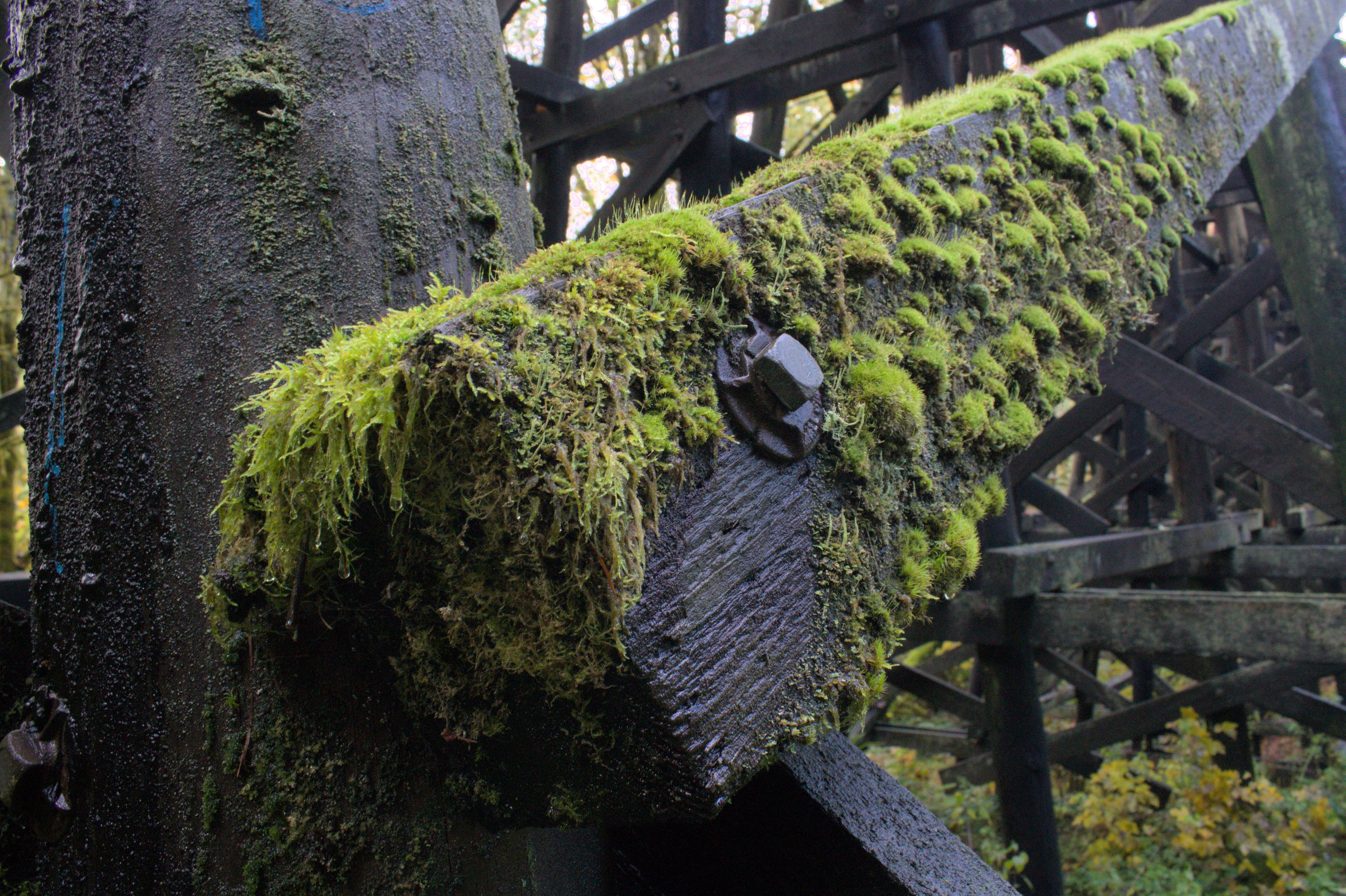
The Buxton Trestle looks like something straight out of a Western movie. Standing beneath the towering structure tempts me to search for scofflaws planting dynamite at its base as part of a train heist. Constructed in 1920, this decommissioned railroad trestle supported passing trains before being converted into a rail trail. Today, you can walk or bike across its 700-foot span while admiring the forest from the canopy level.
The easiest way to see the trestle is by starting from the Buxton Trailhead. If you look past the picnic tables next to the parking lot, you’ll see the first glimpse of the trestle’s dark wood beams through the trees. If you get closer, you can pass underneath it.

Head up the hill from the parking lot, then take a left
To cross the Buxton Trestle from above, head to your right from the parking lot. You’ll pass a small pond and then climb a hill for about 100 feet. At the top of the hill, take a left. You’ll reach the trestle in about 0.1 miles.

Approaching the Buxton Trestle
The walk across the Buxton Trestle is a flat and easy stroll. You’ll hear the rushing water of Mendenhall Creek below as you look out onto a grassy clearing surrounded by a forest of Doug firs, big-leaf maples, and red alders.

Crossing the Buxton Trestle

The trestle rounds a gentle corner, revealing the scenery in stages. The trail surface is modern, but moss and lichen growing from the original trestle structure are reminders of its age. On one beam, an optimistic sapling has grown about six inches tall.
At the end of the trestle, the trail separates into two forks. To the right, the paved Banks-Vernonia Trail continues south to the Manning Trailhead and then to Banks. Heading left will bring you down a short unpaved trail around the base of the Buxton Trestle, which is the best angle to appreciate its height.
After crossing the Buxton Trestle, you can descend to its base
You’ll pass a few picnic tables near the base of the Buxton Trestle. The trail crosses a footbridge over Mendenhall Creek and then returns to the parking area. In total, this short loop is about 0.3 miles.

Picnic area at the base of the Buxton Trestle
Banks-Vernonia Trail

The Banks-Vernonia Trail passes through LL Stub Stewart State Park
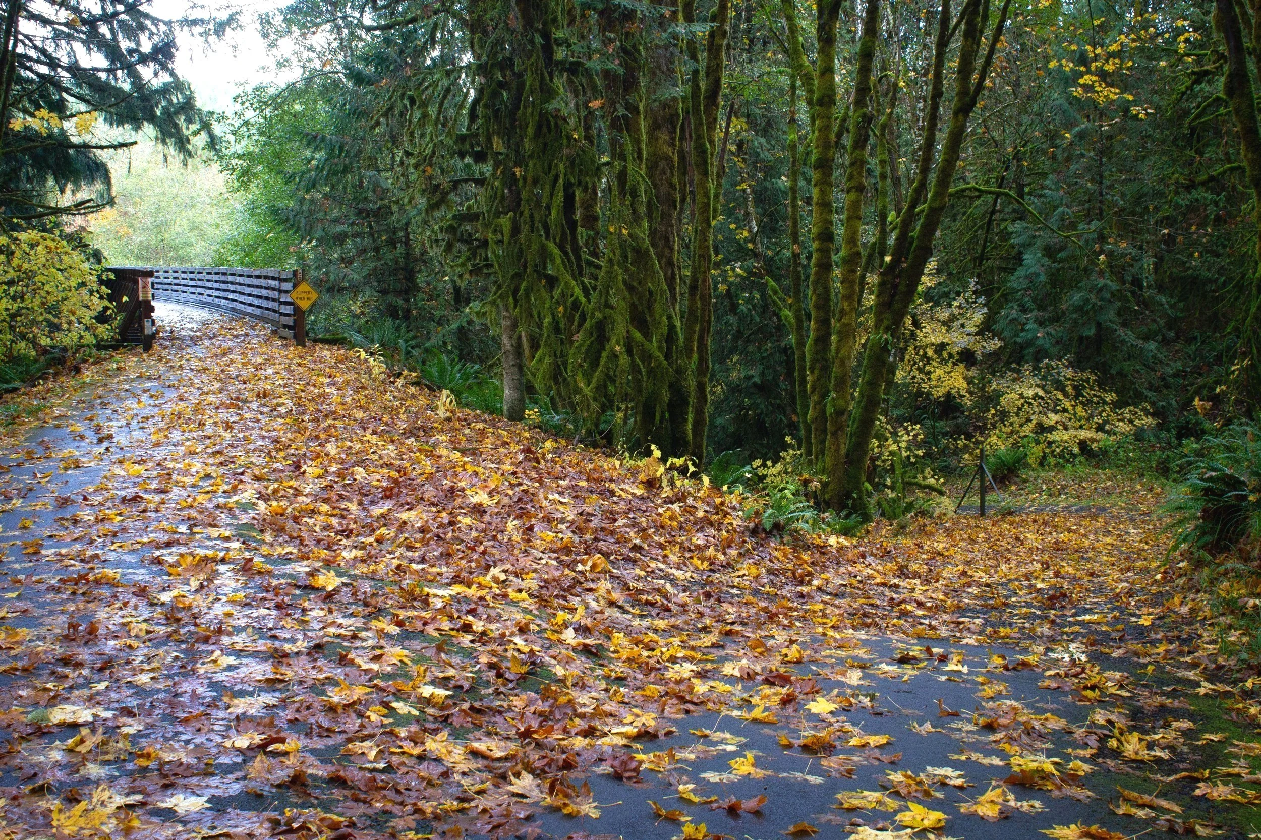
Although you can see the Buxton Trestle with a bare minimum of hiking, it is also a highlight, and I would say the highlight, of the Banks-Vernonia Trail. Once a railroad bed, today this 21-mile paved and gentle trail is a great place to hike, bike, or ride a horse. Usually snow-free and always mud-free, it is a good choice for a winter excursion. I got rained on twice during my hike there and still enjoyed myself. In summer, a forest canopy provides shade along most of the trail. In fall, big-leaf maples add splashes of yellow to the greenery of the conifers, while white, red, and purple mushrooms spring up in the undergrowth.

Banks-Vernonia Trail
A roundtrip journey on the Banks-Vernonia Trail is longer than a day hike and would be an ambitious bike ride, but multiple trailheads allow you to tackle shorter segments. Oregon Hikers covers the entire length of the trail in detail. To see the Buxton Trestle as part of a doable day hike or short bike ride, segments of the Banks-Vernonia Trail to the north and south of it are good choices. You can:
Start at the Manning Trailhead and head north until you reach the Buxton Trestle. Make the little loop around the base of the trestle and then head back. The total distance will be a little under 6 miles. Details below.
Start at the Buxton Trailhead, make the little loop around the Buxton Trestle, and then head north to LL Stub Stewart State Park. You can skip the day-use fee in this state park by hiking or biking in. An optional spur at the end will bring you to a hilltop viewpoint with picnic tables. The total distance is a little over 7 miles.
Start at the Buxton Trailhead, make the little loop around the Buxton Trestle, and then head north to the Tophill Trailhead. You will pass through LL Stub Stewart State Park along the way. You’ll also be able to see (but not cross) the Tophill Trestle. The round-trip distance is a little over 10 miles.
Manning to Buxton Trestle hike

Hike or bike on the Banks-Vernonia Trail to make the Buxton Trestle a destination
Quick stats
Distance: 5.7 miles out and back
Elevation gain: 200 feet
Difficulty: Easy
Pass required: None
Dog friendly: Yes, leashed dogs are welcome on the trails.
ADA access: The Banks-Vernonia Trail between Manning and the Buxton Trestle is wide and paved with minimal grade. There are a few spots where the pavement gets a bit rough. The trail at the base of the Buxton Trestle is unpaved and has a steeper grade than the paved trail. The restrooms at both trailheads, I would say, are not accessible. Look for accessible restrooms at the Banks trailhead.
Season: Year-round

Bridge over West Fork Dairy Creek
The details
The Manning Trailhead has a small parking lot, picnic tables, a vault toilet, and a bike maintenance station. It’s not tempting to linger at the trailhead right next to Highway 26, but the trail heads away from the road, and the noise fades quickly. Just north of the trailhead, you’ll cross a wooden footbridge over West Fork Dairy Creek.

Does this count as wildlife?
The delightfully flat trail begins through farmland. You’ll have a good chance of spotting cows over the blackberry brambles here and an absolute certainty of smelling them. In fall, the trees lining the trail turn yellow, orange, and a soft coral red. You’ll also start spotting signposts at every half mile that quantify your progress.

The beginning of the hike passes through farmland
After about 0.5 miles, you’ll reach a broad clearing of pasture land. In the distance, forested hills rise gently behind the fields. After this clearing, you’ll enter the forest and make the rest of the journey under the branches of Doug firs, big-leaf maples, and alders.

Look for benches along the trail
From here, the trail continues flat and easy, passing benches and picturesque footbridges at intervals. Make sure to stay on the trail since private property surrounds it. You’ll see some interesting-looking dirt roads, but none are public hiking trails. As you get close to your destination, you’ll begin to see Buxton Creek through the trees.

You’ll cross several footbridges on the way to the Buxton Trestle
Shortly after mile marker 6.5 (a little over 2.5 miles from the Manning Trailhead), you’ll round a corner and see the fork in trail just before the Buxton Trestle. Keep left to cross the trestle from above.

Buxton Trestle
After crossing, follow the paved trail about 0.1 miles, then take a right to head past a little pond and the Buxton Trailhead parking lot. After passing the parking lot, take the unpaved trail around the base of the trestle, then keep left at the fork to return the way you came.

After making the loop around the trestle, return the way you came
Getting there
To reach the Buxton Trailhead from Portland, take Highway 26 W until NW Fisher Rd, then take a right. Follow NW Fisher Rd for 0.7 miles, then continue straight onto NW Bacona Rd. In half a mile, turn right to reach the parking lot for the Buxton Trailhead. Take the paved trail to the right past the picnic shelter to head to the trestle. The drive from Portland takes about 40 minutes.
Enjoy your day exploring the Buxton Trestle and the Banks-Vernonia Trail!
With love,
Emma
Explore nearby

Try out the best short hikes on the north Oregon Coast.

Find more great winter hikes near Portland.