

Government Camp to Enid Lake Snowshoe Trail


Disclaimer: Post contains affiliate links
The peaceful snowshoe trail to Enid Lake on the slopes of Mt Hood is a great alternative to the often-crowded Trillium Lake. I went on a weekend day after a fresh snowfall and saw only a handful of other people. One cross-country skier told me she had tried and failed to find a parking spot at Trillium Lake and one of the Sno-Parks before coming. The trail is stunning, especially when snow covers the conifer boughs and rhododendron bushes. Despite being within easy walking distance from Government Camp’s resorts, restaurants, and bus stops, the forest feels like a secret. Here is how to snowshoe or ski to Enid Lake.

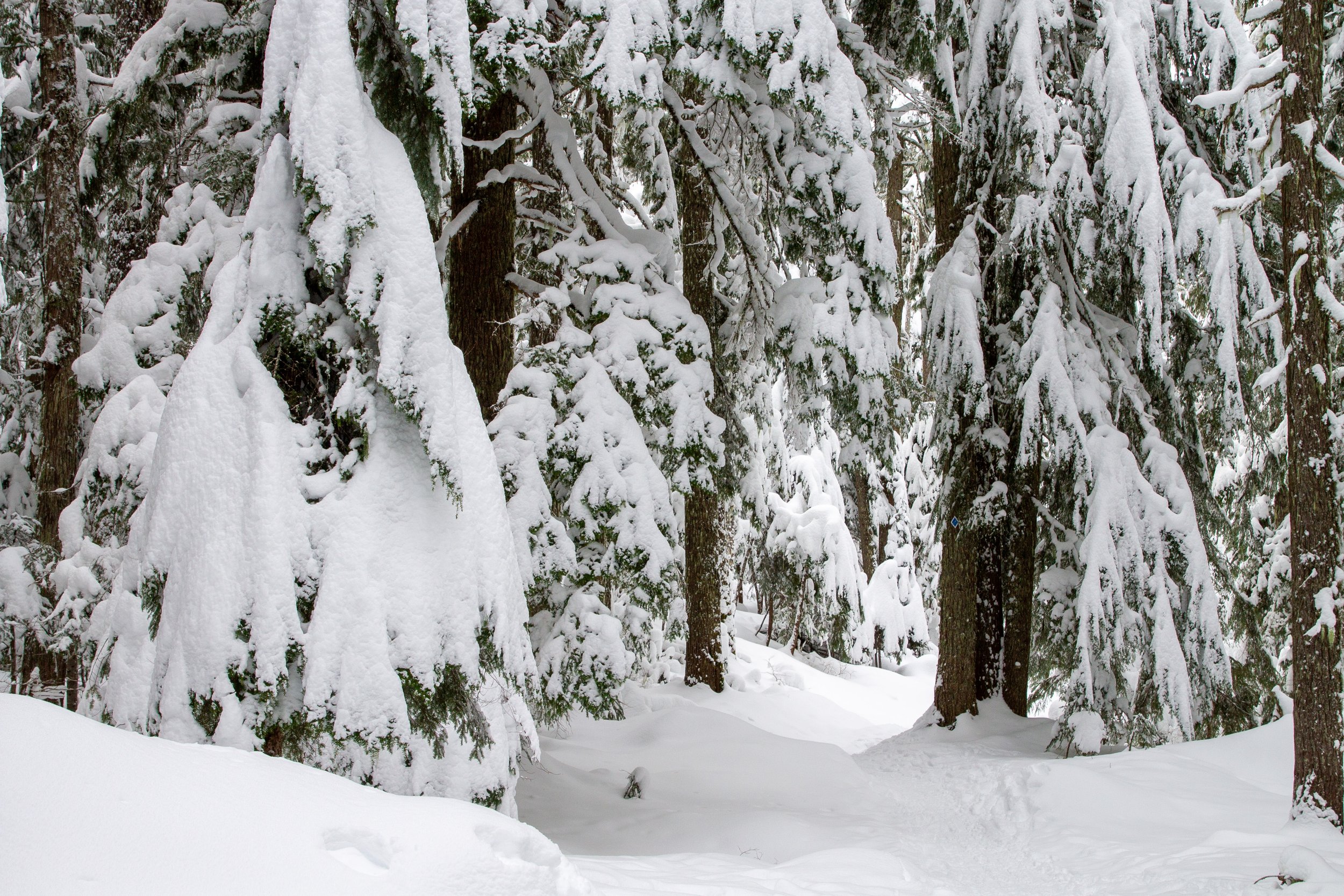
Trees along the trail to Enid Lake bend under heavy snow
Know before you go
Parking in Government Camp requires an Oregon Sno-Park Pass from November through April. It costs about $4/day. Several vendors in Government Camp sell them. Collins Lake Resort is the closest vendor to the trailhead. Parking is free during the summer.
If you visit from November through April, prepare for winter driving conditions. Bring a 4WD vehicle and carry chains or use traction tires. If, like me, you don’t have this type of vehicle, you can take the Mt Hood Express from Sandy to Government Camp.
Leashed dogs are welcome on the trail to Enid Lake.
The trailhead doesn’t have restrooms or other amenities.
The trail to Enid Lake is family-friendly. It’s a great choice if you’re new to snowshoeing or cross-country skiing.
There are several ways you can ski or snowshoe to Enid Lake. I’ll discuss the route starting from Maggie’s Trail in Government Camp. It’s a satisfying distance and takes you through some beautiful scenery.
The trail to Enid Lake is shared between snowshoers and cross-country skiers in the winter. Try to stay off ski tracks if you’re snowshoeing.
Maggie’s Trail
What to bring
Trail conditions around Government Camp can vary quite a bit based on what the weather’s been doing. If you visit Enid Lake during the winter, snowshoes or cross-country skis are good choices for gear. To explore off the trail, like around Enid Lake, snowshoes will be the easiest to use in deep snow. If it hasn’t snowed for a while, the trail may be packed down enough to get by with microspikes.
Mt Hood Outfitters in Government Camp rents equipment. The shop is less than a half mile from the start of Maggie’s Trail. Snowshoe rental for the day is $20 (adults) or $15 (kids). Cross country skis are $30 (adults) or $25 (kids).
Dress warm and wear layers, including a winter coat, hat, gloves, and wool socks. Avoid cotton base layers. Merino wool or synthetic fabrics will repel moisture and keep you warmer. Bring water and trail snacks. Wear waterproof snow boots. If your boots don’t come up above your ankles, wear snow pants or snow garters.

Enid Lake
On the trail to Enid Lake
Distance: 2.5-mile lollipop loop
Elevation gain: 300 feet
Difficulty: Easy
Pass required: Sno-Park Pass November - April
Dog friendly: Yes, leashed dogs are welcome on the trail.
ADA access: No
Season: All year. Expect snow on the trail from around December until April or May.
Basic directions:
Start on Maggie’s Trail, keeping left at the first fork.
In 0.3 miles, keep right at junction #4.
In 0.2 miles, keep left at junction #3.
Take a left in 0.5 miles at junction #2 and continue around the Enid Lake Loop.
After returning to junction #2, keep left to head back the way you came.

Map data courtesy of Google Maps, copyright 2025. Annotations are mine.
The details
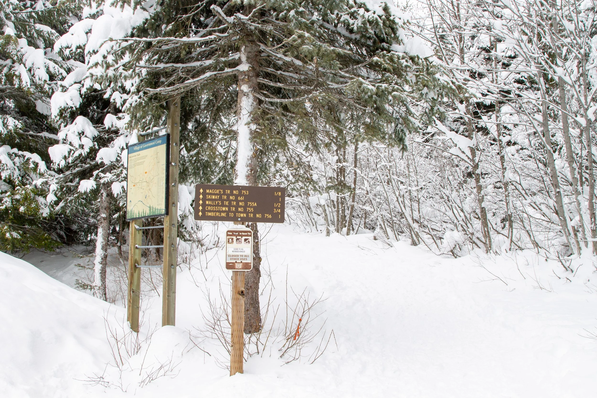
The shared snowshoe and cross-country ski route to Enid Lake starts from Government Camp Loop Rd. The trailhead is just to the right of the Thunderhead Lodge. If you drive here, park along the side of the road near the trailhead. You’ll see a sign pointing to Maggie’s Trail and a large map.
Start here
If you see a sign for the Thunderhead Trailhead just ahead, you’re in the right place.

Look for this sign once you start the trail
You’ll reach a fork in about 100 feet. Keep left to start Maggie’s Trail #753.

Keep left at the sign
Even on beautiful weekend days in winter when Mt Hood is overrun with visitors, Maggie’s Trail is quiet. On a Sunday after a fresh snowfall, the bus ride to Government Camp was so crowded that people stood in the aisle on the drive up. Once I got to Maggie’s Trail, I felt like the only one in the forest. On top of the solitude, snow has a way of dampening sound. I heard only my breath, the rhythmic slapping of my snowshoes, and occasional piles of snow sliding off conifer boughs.

Fresh snow covers the trees along the trail
Most trail junctions around Government Camp are labeled. I’d still recommend having an offline map, especially in winter. Below freezing temperatures make it more important than usual to keep your bearings. Fresh snow can cover the trail and make it harder to follow. Look for blue diamonds along the way. They mark cross-country ski routes.

Blue diamonds on tree trunks mark the winter trails
Besides a few gentle ups and downs, Maggie’s Trail is flat and easy. On a chilly day after overnight snow, there’s more white than green. Snow covers every bough. Flexible mountain hemlocks bend with the weight of it. The still green leaves of rhododendron bushes droop under tiny white piles. Despite the uniformity of the scenery, every turn makes it feel like you’ve found an undiscovered world where elves and spirits dwell. Toward the beginning of the hike, you’ll cross a power line corridor. On a clear day, look for a glimpse of Mt Hood.

Maggie’s Trail
The trail junctions around Government Camp are numbered. After 0.3 miles, you’ll reach junction #4, marked with a sign. Keep right to stay on Maggie’s Trail.

Keep right at junction #4
In another 0.2 miles, you’ll reach junction #3. Keep left this time. You’re joining up with the Crosstown Trail and heading toward Glacier View Sno-Park.
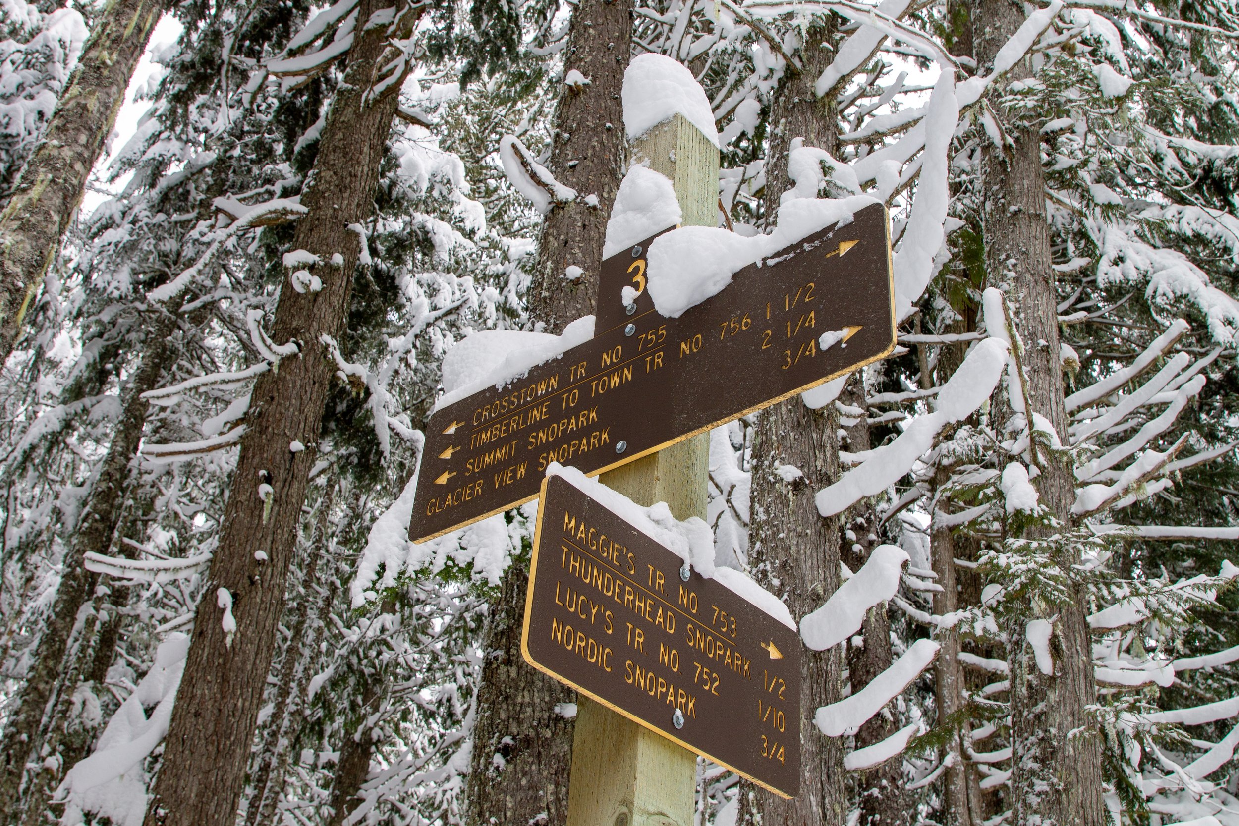
Keep left and head toward Glacier View Sno-Park
After junction #3, you’ll snowshoe or ski 0.5 miles to reach the Enid Lake Loop. The loop begins at junction #2. This sign has a helpful trail map, although you probably won’t need it by this point. You can go in either direction at the junction. We’ll go left to start the loop clockwise. This direction will get you to the lake sooner.

Start of the Enid Lake Loop
Once you start the Enid Lake Loop, you’ll cross the first of several snow-covered bridges over little streams.

Cross here
You’ll get the first glimpse of Enid Lake after a quarter mile on the loop. In winter, it looks like a snowy clearing rather than standing water.

First glimpse of Enid Lake
A thin screen of trees separates Enid Lake from the trail. With snowshoes, it’s easy to walk between them to reach the clearing.

A little spur trail leads to Enid Lake
Enid Lake is a dazzling snowscape. While it lacks the drama and wow factor of Trillium Lake, it has the same quiet beauty as the trail through the forest. Most days in winter, the cloud cover will block the views of Mt Hood. Even when it’s clear, you don’t see much more than a glimpse of the summit. In warmer seasons, the lake is small and marshy.

Enid Lake
If you have snowshoes, you can explore the lakeshore a bit. I’d be cautious about walking across in case you fall through the snow and end up with wet feet. Even with the temperature in the 20s, I saw running water around the lake.

Made it!
After seeing Enid Lake, return to the trail and continue around the loop. About 0.2 miles will bring you to Glacier View Sno-Park, an alternate trailhead for the snowshoe trip. There’s a picnic table buried under piles of snow here but no restrooms.

The Glacier View Sno-Park has a parking area
When I visited, someone had made an excellent snow fort next to the parking lot.

Kudos on the snow fort
A little past the Sno-Park is a trail junction. Keep right to take the Pioneer Bridle Trail and continue on the Enid Lake Loop.

Keep right
In 0.2 miles is another trail junction. Keep right again, following the arrow on the half-broken sign toward the Crosstown Trail.

Follow the broken sign
In a half mile, you’ll be back at the start of the Enid Lake Loop, junction #2. Take a left to return the way you came.

End of the Enid Lake loop
Enjoy your snowshoe or ski trip to Enid Lake!
With love,
Emma
Getting there
By car
Maggie’s Trail #753 is in Google Maps, but not its trailhead. Instead, I’d suggest navigating to Thunderhead Lodge, which is right next to the start of the trail. Park on the side of the road using an Oregon Sno Park Pass in winter. I visited on a busy weekend day, and there was plenty of parking available.
By bus
One of the cool things about the Enid Lake snowshoe trail is that you can reach it by bus. Take the Mt Hood Express from Sandy, Oregon. Get off at the Best Western stop in Government Camp. The trailhead is 0.2 miles down Government Camp Loop Rd.
Explore nearby

Check out other easy snowshoe trails on Mount Hood.

Find the best short hikes on Mt Hood.
