

5 Great Hikes at Beacon Rock State Park

Surrounded by the rounded and subtle contours of the Columbia Gorge, Beacon Rock’s jagged peak draws the eye for miles around. This 848-foot spire of basaltic andesite is the core of an extinct volcano, left standing after powerful floods at the end of the last ice age stripped away its exterior rock. Around 15,000 years later, it narrowly escaped destruction by dynamite. Today, it is the namesake of Washington’s beloved Beacon Rock State Park. The trail to Beacon Rock’s summit is one of the most extraordinary hikes near Portland and yet is only the beginning of the park’s attractions. Only 45 minutes from the city, you may want to return more than once to enjoy the waterfalls, mountain vistas, and wildflowers. Here is everything you need to know about hiking in Beacon Rock State Park.

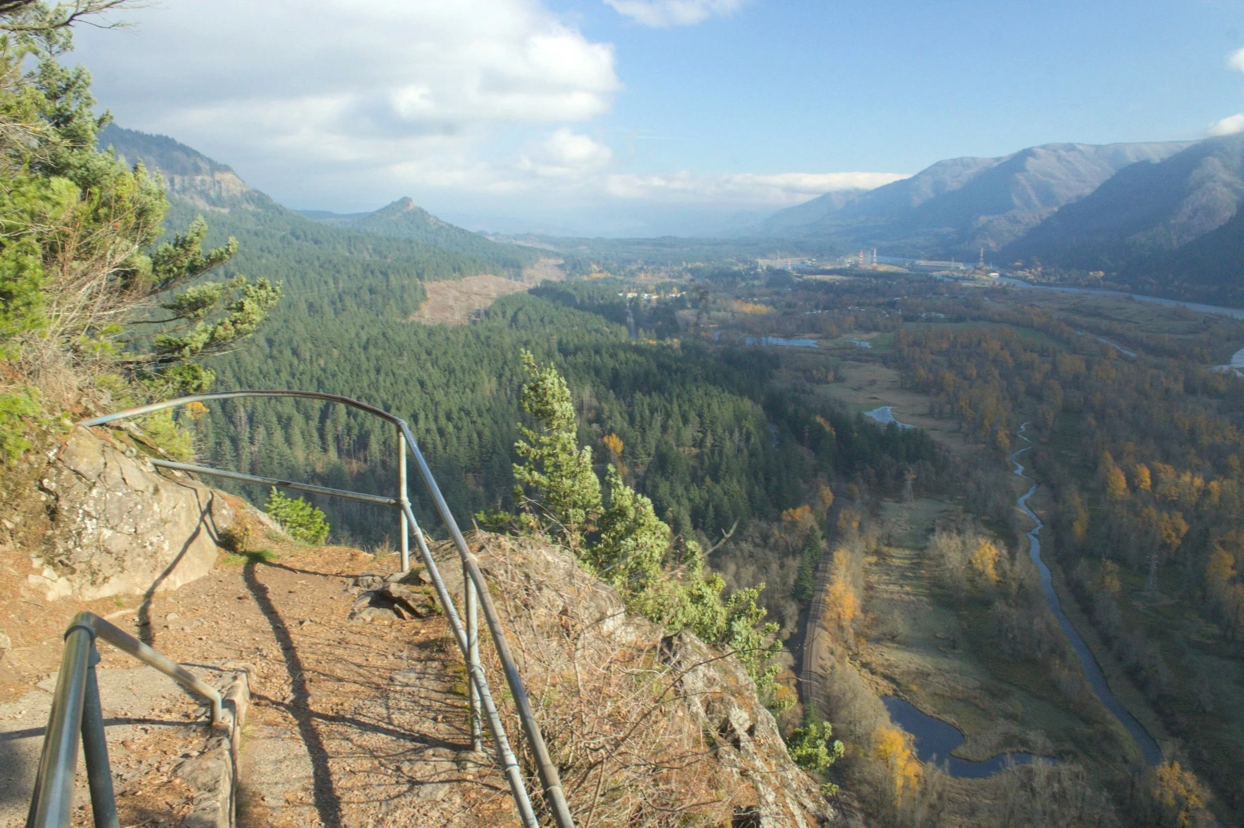
Views from the Beacon Rock Trail
Know before you go
Cost: To park in Beacon Rock State Park, you’ll need a Washington Discover Pass. It costs $10/day or $45/year. You can buy a pass online ahead of time or at the pay stations on-site. Each parking lot has a pay station.
Parking: Beacon Rock State Park has three separate parking areas for day use, each accessing a different part of the park. The most obvious is the lot just off Highway 14 at the base of Beacon Rock. Use this lot to hike to the summit (hike #1 on this list). Just west of this lot is a turn that will take you to the Doetsch Day Use Area. Use this parking lot to reach the Beacon Rock Boat Launch and two lesser-known hiking trails (hikes #2 and #3). Hike #2 connects these first two parking lots. Across Highway 14 is a third lot for the Hamilton Mountain trailhead (hikes #4 and #5). It’s easy to reach all three parking lots in a low-clearance vehicle.
Amenities: Look for restrooms and picnic tables next to all three parking lots. The best picnic areas are next to the Hamilton Mountain Trailhead, the Beacon Rock Campground, and the Doetsch Day Use Area. There is a playground near the Hamilton Mountain trailhead.
Crowds: The parking lots for the Beacon Rock Trail and the Hamilton Mountain Trail fill up quickly on summer weekends. The Doetsch Day Use Area doesn’t.
Dogs: Leashed dogs are welcome in Beacon Rock State Park.
Season: Beacon Rock State Park is usually a good choice for year-round hiking. It occasionally gets snow and ice. I would skip hiking up Beacon Rock if the trails are icy. Expect snow near the top of Hamilton Mountain in the winter.
Winter access: A gate sometimes blocks access to the Hamilton Mountain Trailhead in winter. If this happens, you can park across Highway 14 at the Beacon Rock Trailhead and hike up the hill to the Hamilton Mountain Trailhead, which adds a 1-mile roundtrip distance to your hike.
1. Beacon Rock Trail

The hike up Beacon Rock has great views of the Columbia Gorge
Distance: 1.8 miles out and back
Elevation gain: 680 feet
Difficulty: Moderate
Pass required: Washington Discover Pass
Dog friendly: Yes, leashed dogs are allowed on the trail.
ADA access: No

The trail up Beacon Rock is almost as impressive as the views
If you only do one hike in Beacon Rock State Park, do this one. The journey to the top of Beacon Rock is memorable both for the incredible views and the engineering of the trail itself. Rail-lined ledges and switchbacks make the trek up this ancient volcanic core safe as you take in the scenery, but be careful with small children. The single rail is not impenetrable. Frequent viewpoints along the way overlook the Columbia Gorge in all directions. The first part of the hike climbs Beacon Rock’s western face with views out to Cape Horn. Watch for barges making their way along the Columbia River and bald eagles overhead. Towards the end of the hike, you’ll be looking east with views of Hamilton Mountain, Table Mountain, and Bonneville Dam.
Looking east toward Bonneville from the Beacon Rock Trail
Many viewpoints on the way up are more impressive than the one at the summit, which is somewhat enclosed by tree cover. Once you reach the top, it’s worth taking a moment to visualize Beacon Rock’s staggering geologic history. At the end of the last ice age, an ice dam broke near present-day Missoula, Montana, releasing massive amounts of glacial meltwater across Idaho, eastern Washington, and the Columbia Gorge. Standing at the top of Beacon Rock, you would have heard the rumbling of the approaching floodwater long before it arrived. When it did, a muddy, churning deluge carrying debris and floating icebergs would have rushed toward you at around 60 mph. At times, the water level was hundreds of feet deep, almost reaching Beacon Rock’s summit.

See the Columbia River and the forested hills of Oregon from Beacon Rock’s summit
2. River to Rock Trail

The boat dock is a great place to see Beacon Rock and Hamilton Mountain
Distance: 1.6 miles out and back
Elevation gain: 300 feet
Difficulty: Easy
Pass required: Washington Discover Pass
Dog friendly: Yes, leashed dogs are allowed on the trail.
ADA access: No

Look for the stone frame of a building along the trail
The River to Rock Trail connects the boat dock on the Columbia River to the base of Beacon Rock. This short and sweet trail is a peaceful place to escape the crowds. Before starting the hike, head down to the dock, where you can see the full height of Beacon Rock rising from the forested riverbanks. Next to it is the gentler slope of Hamilton Mountain. After taking in the views from the water level, head back to the parking lot and pass under the railroad trestle to find the trail. From here, you’ll climb gradually through an uncrowded forest.

Larkspur blooms along the River to Rock Trail
Look for larkspur and daffodils blooming along the trail in summer. Garter snakes slither away from the path as you walk, a testament to how few people make this journey. You’ll pass the remains of a stone building covered with moss and topped with maidenhair ferns. A little farther, you’ll see Beacon Rock looming over the tall grasses of marshy Riddell Lake. After an easy 0.8 miles, you’ll reach the base of Beacon Rock. From here, you can turn around or take the Beacon Rock Trail to the summit for a total distance of about 3.5 miles. This trail is also easy to combine with the Beacon Rock Doetsch Walking Path (hike #3, below).
Riddell Lake
3. Beacon Rock Doetsch Walking Path

The Beacon Rock Doetsch Walking Path is paved, flat, and even
Distance: 1.2-mile loop
Elevation gain: Minimal
Difficulty: Easy
Pass required: Washington Discover Pass
Dog friendly: Yes, leashed dogs are allowed on the trail.
ADA access: This paved loop trail is wide, flat, and even without steps or steep grades. Accessible parking and restrooms.

Dog roses bloom next to the Beacon Rock Doetsch Walking Path
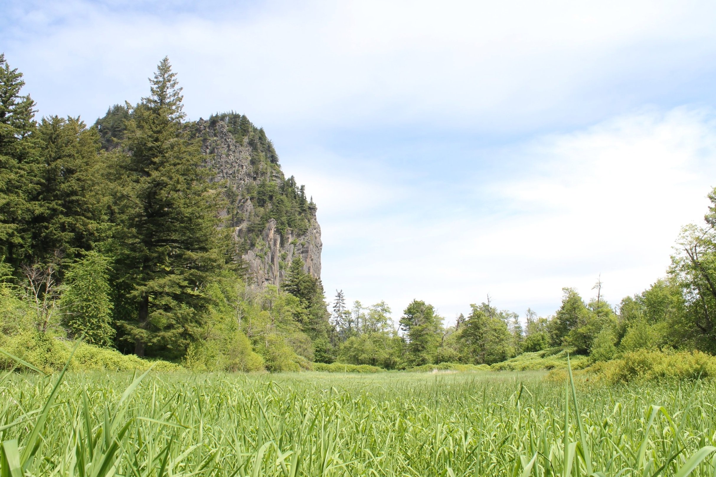
If you’re looking for solitude, the Beacon Rock Doetsch Walking Path is the least traveled hike in Beacon Rock State Park. When my friends and I visited on a beautiful summer weekend, we were alone on the trail. This pleasant and scenic hike makes an easy, mile-long loop around a meadow that was once a homestead and cattle ranch. The trail begins at a pretty picnic area with a few large trees for shade. There is also a reservable picnic shelter. From here, head in either direction to start the loop hike. Look for flowering bushes and wildflowers like phlox along the trail during late spring and early summer. In fall, cottonwoods and big-leaf maples surround the trail with yellow.

Doetsch Walking Path in late fall
On the far side of the loop, you’ll be walking along the Columbia River, although you never get more than a hint of it through the dense tree cover. You will, however, get a lovely view of Beacon Rock beyond the grassy field. Look for bald eagles circling overhead and Steller’s jays in the trees. For a laid-back day, you can stop here after your hike, have a picnic, and then head to the boat dock to admire the views. For more distance, you can also hike the River to Rock Trail and, if you want, up Beacon Rock.

Look for Beacon Rock from the trail
4. Hardy Falls, Rodney Falls, and Pool of the Wind

Viewpoint above Hardy Falls
Distance: 2.5 miles out and back
Elevation gain: 600 feet
Difficulty: Easy
Pass required: Washington Discover Pass
Dog friendly: Yes, leashed dogs are allowed on the trail.
ADA access: No

A footbridge crosses Rodney Falls
The trail to Hardy Falls, Rodney Falls, and Pool of the Winds is one of the great waterfall hikes of the Columbia Gorge. In a little over a mile, it will take you to the three waterfalls along Hardy Creek, each with a different character. Starting from the trailhead and its generous amenities, you’ll hike steadily uphill through a forest of Doug firs. About 0.4 miles into the hike, you’ll reach a clearing with a view of Hamilton Mountain and the Columbia River, albeit with some power lines passing overhead. In this clearing, you’ll pass a trail junction. Head left to make an optional side trip out to Little Beacon Rock. Keep right to head toward the waterfalls. After about a mile from the trailhead, you’ll reach 90-foot Hardy Falls. A fenced and family-friendly viewpoint overlooks Hardy Creek as it approaches the falls. For the best (but still slightly obstructed) view of Hardy Falls, proceed with caution to the unfenced viewpoint near a steep drop-off.

Hardy Falls
Continue on the Hamilton Mountain Trail through the forest until you reach Rodney Falls cascading over angular dark stone. A short spur trail will bring you up to Pool of the Winds, where Hardy Creek drops 20 feet through a surprising 20-foot hollow cylinder in the volcanic rock. Thick clouds of mist created by the force of the rushing water spray out toward you as you admire the unique waterfall. After seeing Pool of the Winds, cross the wooden footbridge over Rodney Falls to take in its unusual contours. Turn around after seeing Rodney Falls or continue on the trail to hike up Hamilton Mountain.

Pool of the Winds
5. Hamilton Mountain Trail

Hamilton Mountain Trail
Distance: 7.5-mile lollipop loop (or 5.5 miles out and back)
Elevation gain: 2,000 feet
Difficulty: Hard
Pass required: Washington Discover Pass
Dog friendly: Yes, leashed dogs are allowed on the trail. Stay on the trail to avoid steep drop-offs.
ADA access: No

Rodney Falls
Although not easy, the rewarding hike to the top of Hamiton Mountain is one of the less intense and more approachable mountain hikes in the Columbia Gorge. You’ll begin the journey by hiking to Hardy Falls, Rodney Falls, and Pool of the Winds. Instead of stopping at Rodney Falls, you can continue on the dirt trail up the mountain. After you pass the falls, the trail becomes noticeably steeper and rougher. You’ll soon reach a fork that marks the beginning of the loop portion of the hike. Keep right. The tree cover thins as you climb, and the views soon change from forest to vistas. You’ll pass a few short spurs out to overlooks next to steep drop-offs. Don’t bring kids or dogs on these spurs.

Spur on the Hamilton Moutain Trail
If you continue, you’ll soon reach a safer overlook at Little Hamilton Mountain and, arguably, the best views on the hike. From this rocky outcropping, look for the tiny-looking Beacon Rock at the base of the Columbia Gorge. Across the Columbia River, you’ll see Oregon’s Nesmith Point. On a clear day, look for Mt Adams to the east. From here, you’ll follow a ridge out to Hamilton Mountain’s summit. You can turn around at the summit to make a shorter but steeper out-and-back journey or continue to make a gentler descent on the loop portion of the trail. Whichever way you choose, the waterfalls make for a refreshing sight on the way back.

Nesmith Point and Beacon Rock from the Hamilton Mountain Trail
Geology of Beacon Rock
Beacon Rock is a 57,000-year-old extinct volcano, the youngest member of the enigmatic Boring Volcanics. Although named for their location rather than to disparage their conversational ability, the Boring Volcanics are, at least in terms of molten lava erupting from the earth, kind of boring at first glance. Younger, smaller, and covering less ground than the Cascade Mountains, they tend to get forgotten in the Pacific Northwest’s volcanic mosaic. On a closer look, they form some of the most interesting landmarks around Portland, including Mt Tabor, Rocky Butte, and Larch Mountain.

Beacon Rock is the core of a volcano
Beacon Rock’s appearance changed dramatically around 15,000 years ago after catastrophic floods tore through the Columbia Gorge. As global temperatures rose at the end of the last ice age, glacial meltwater accumulated behind an ice dam, forming Glacial Lake Missoula. This ice dam broke, sending floods across Idaho, Washington, and the Columbia Gorge. The force of the rushing water stripped away Beacon Rock’s exterior, leaving behind its core of basaltic andesite. The Beacon Rock Boat Launch is the best place to admire the columnar jointing on its southern face.
Getting there
To reach Beacon Rock State Park from Portland, head to Washington and take Highway 14 E. Continue until you arrive at the park. You’ll first reach a right turn leading to the Doetsch Day Use Area (hikes #2 and #3), marked with a sign. A mile east on Highway 14, you’ll see the parking lot for the Beacon Rock Trail (hike #1) next to the road on your right. Across Highway 14 from this parking lot, a non-descript road leads to the Hamilton Mountain Trailhead (hikes #4 and #5). The drive from Portland takes about 45 minutes.
Enjoy your trip to Beacon Rock State Park!
With love,
Emma
Explore nearby

For another excellent waterfall hike in southwest Washington, head to Falls Creek Falls.

Visit the idyllic swimming hole beneath Dougan Falls.

After exploring Beacon Rock, try out the other best hikes within an hour of Portland.
Reference:
Tucker, Dave. Geology Underfoot in Western Washington. Mountain Press Publishing Company, 2015.