

How to Hike or Snowshoe to Tamanawas Falls in Winter


Disclosure: Post contains affiliate links
As I wait for more spring wildflowers to bloom, I thought it would be fun to do the hike out to Tamanawas Falls as a last winter hurrah. Easily one of the best waterfall hikes around Mt Hood during any season, Tamanawas Falls has a stark and haunting beauty in winter when a fine mist rises from the pool at its base and hangs above piles of blue-white snow. To get there, you’ll follow a trail alongside Cold Spring Creek, where clear water flows around snow-covered boulders under a canopy of Doug firs, Western hemlock, and cedars. If you are on the hunt for a good beginner snowshoe trail, look no further. Here is everything you need to know to hike to Tamanawas Falls in winter.

Behind Tamanawas Falls
Know before you go
The Tamanawas Falls Trailhead is on the east side of Mt Hood. The parking lot looks like a widened shoulder next to Highway 35. It is fairly small and fills up quickly on weekends, although more so during the summer.
The roads leading to the trailhead have chain requirements in winter. Carry chains or use traction tires when requirements are in place. You’ll see lighted signs along the highway when you need them.
It was trickier than usual to find out what pass I needed to park in winter. There were no signs about pass requirements at the trailhead and I found conflicting information online. According to the most reliable information source, the US Forest Service, you need the NW Forest Pass or America the Beautiful Pass year-round. As far as I can tell, you do not need a Sno Park Pass.
Leashed dogs are welcome on the trail.
There is a restroom at the trailhead.
The hike to Tamanawas Falls is family-friendly, although icy conditions may make it challenging in winter without the right gear.
You will probably want to bring snowshoes or microspikes to hike in winter (more on that below). Regardless of which you pick, be sure to wear waterproof hiking boots. I’d suggest this pair for women or these for men.

Spikes or snowshoes
If you are hiking to Tamanawas Falls in winter, it is a good idea to bring either microspikes or snowshoes. Since this trail is very popular, the snow is often packed down enough to make microspikes ideal. If there’s been recent snow, snowshoes may be a better choice. You may be okay without either depending on the trail conditions but will probably have an easier time if you have some sort of traction. On the day I went, the trail was very icy and I think I would have turned around early if I didn’t have microspikes.
You can rent gear in the town of Sandy, Portland, or Hood River on the way out to the trailhead. Snowshoe rental is about $20/day and microspike rental is about $8/day.

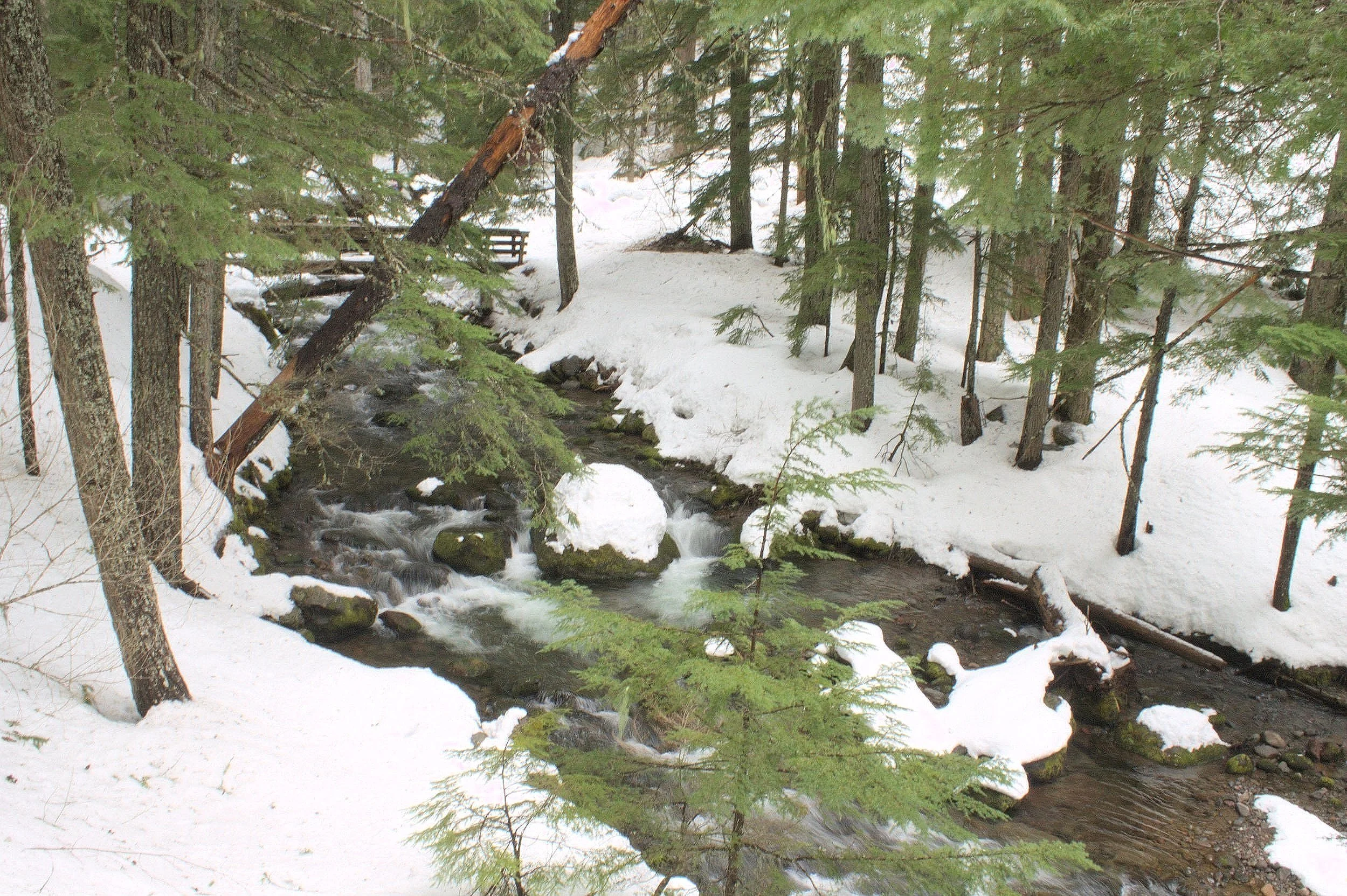
The trail follows Cold Spring Creek for most of the hike
Hiking the Tamanawas Trail
Distance: 3.5 miles
Elevation gain: 600 feet
Difficulty: Moderate
Pass required: Northwest Forest Pass or America the Beautiful Pass
Dog friendly: Yes, leashed dogs are welcome on the trail.
ADA access: No
Basic directions: From the trailhead, head down to the footbridge over Cold Spring Creek. Follow the Tamanawas Falls Trail until you reach the waterfall. You’ll pass a couple of intersecting trails along the way. Keep left at both junctions. Signs at the trail junctions point the way to the falls. After seeing the falls, return the way you came.

A footbridge near the parking lot will bring you to Tamanawas Falls Trail
On the trail:
Find the trailhead next to the restroom near the middle of the parking area. Head down the trail about 0.1 miles and take the wooden footbridge over Cold Spring Creek. The trail follows the creek for most of the hike, providing glimpses of its many small cascades along the way. After crossing the footbridge, veer right to stay on the trail. You’ll begin climbing gently but steadily as you walk through the pines.

After about 0.5 miles, you’ll round a corner overlooking Highway 35 and the impressive cliff across the road. Look for the massive columns at the top of the cliff. Once you round this corner, you’ll head away from the road deeper into the forest.
Approaching the second footbridge on the trail
You’ll soon reach a trail junction where the Tamanawas Falls Trail intersects with the East Fork Trail. Keep left here. A sign at the junction will point you toward the falls. Continue on the trail and you’ll reach a second wooden footbridge crossing Cold Spring Creek. Take the bridge across the creek.

Interesting bug walking through the snow next to the trail
Continue on the trail alongside Cold Spring Creek as you climb gradually upwards. Look for cascades and miniature waterfalls along the creek that start to look more impressive the closer you get to the falls. You’ll soon crest a small hill and see a slope covered with boulders. There is a trail junction just before the boulder field. Keep left to head toward the falls. You’ll see a sign at the junction.

Trail junction before the boulder field
Once you reach the boulder field, you are almost to the falls. Climb up the snowy hill through giant chunks of andesite, some of which will tower over your head. The rocks here come from an andesitic lava flow that erupted locally around 30,000 years ago. Andesite from this lava flow also forms the cliff behind Tamanawas Falls.

Andesite cliff and boulder field below
After you hike up the hill through the boulder field, you’ll round a corner at the top. Around this corner are the first views of Tamanawas Falls. From here, it’s a short, easy stroll to reach the base of the falls.

First view of Tamanawas Falls
Base of Tamanawas Falls
Standing at the base of Tamanawas Falls feels surreal in winter. Cold mist drifts from the waterfall and settles onto piles of snow, which are memorable for their subtle blue color. When I visited in spring, the snow had been compacted into layers reminiscent of sandstone. A small creek flows out from the base of the falls through a canyon of this striated snow.

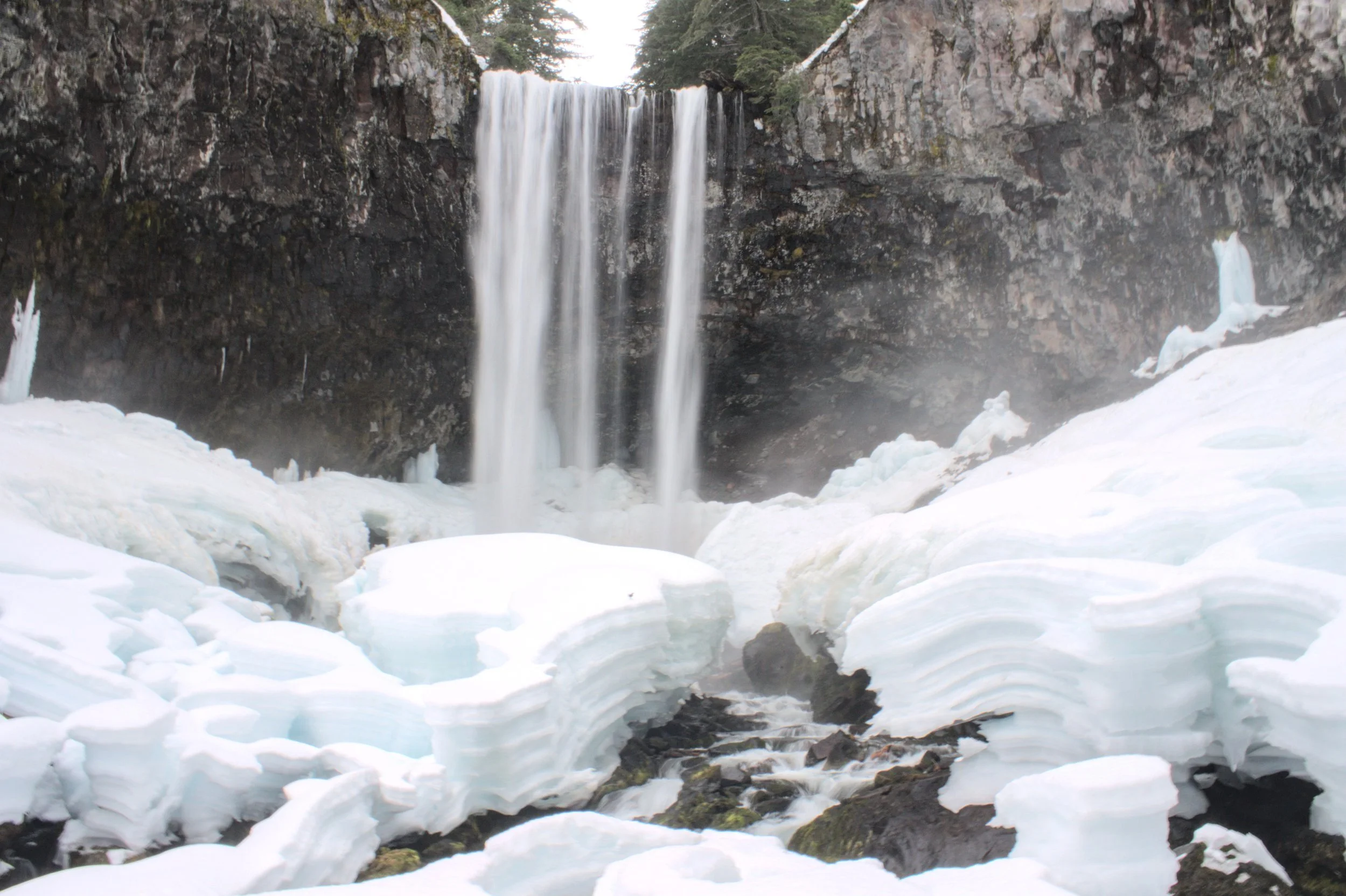
Hiking behind Tamanawas Falls
Depending on the trail conditions, the base of the falls may be as far as you want to go. If you explore behind the falls, expect to be covered by a cold, wet mist during the trek. The rocks and snow here can also get slippery as the mist settles onto them and freezes. I found microspikes very helpful.

Behind the falls, look for bizarre formations of blue-tinted ice in the recess of the eroded andesite cliff. A thick ring of ice surrounds the pool at the base of the falls, forming intriguing icicles and crevices.

Before you get soaked through with cold mist, head back the way you came to return to the car. The way back will be refreshingly downhill.

Getting there
To reach the Tamanawas Falls Trailhead from Portland, you can go one of two ways:
1) Take I-84 East for about 60 miles, then take Exit 64 to get onto Highway 35 South. Follow Highway 35 South for about 24 miles. The parking lot for the Tamanawas Falls Trailhead will be on your right.
2) Take Highway 26 East for about 50 miles, then take the exit for Highway 35 North. Follow Highway 35 North for about 15 miles. The parking lot will be on your left.
Both directions take about 90 minutes. The first route avoids the area of congestion that forms around Timberline Lodge on pleasant weekend afternoons in winter. If you are renting gear, the second route passes through the town of Sandy, which is an easy stop on your way to and from the trailhead.
Explore nearby

For another great snowshoe trail that’s not too challenging, try out the rewarding trek to Trillium Lake.

Check out other easy snowshoeing trails near Portland.

Mt Hood Brewing Co
Stop by Government Camp on your way back to town for a well-earned lunch and beer. Mt Hood Brewing Co, Ratskeller, and Charlie’s Mountain View would all be good choices.
Enjoy the hike to Tamanawas Falls!
With love,
Emma
Reference:
Scott, William E., and Cynthia A. Gardner. Field-trip guide to Mount Hood, Oregon, highlighting eruptive history and hazards. No. 2017-5022-G. US Geological Survey, 2017.