

Hike to the Knoll and the Thumb in Lincoln City, OR


If you’ve been to the beach at Lincoln City, Oregon, you’ve seen the dramatic rise of the Thumb, sometimes called God’s Thumb, just north of town. The headland looms over Road’s End Beach with a shape that reminds me of whipping cream when it forms soft peaks, a steep and rounded parabola. A hiking trail leads to the top of the Thumb, but there are drawbacks. It’s informal, controversial, and, honestly, not very safe. I’d tell you to skip it except that the views at the end are nothing short of mind-blowing. Unlike most of my hiking guides, this one is less of a recommendation and more about giving information. If you go, here’s how to do it. Or, stop at the Knoll, an official and encouraged hike that has a stunning viewpoint of its own. Here is everything you need to know about hiking to the Knoll and the Thumb in Lincoln City.
Views from the Thumb
Know before you go
It’s free to hike to the Knoll and the Thumb. You don’t need a pass or permit to park.
Leashed dogs are welcome on the trail.
The hike to the Knoll is family-friendly. Continuing to the Thumb is not. It has steep drop-offs next to an unmaintained trail.
Have an offline trail map with you. Hikers sometimes get confused and end up on private land.
This hike is often muddy. Although doable in sneakers, hiking boots are better.
Don’t leave valuables in the car.
Trailheads and parking
Two starting points access the hike to the Knoll and the Thumb. Parking is free at both of them.
Villages Trailhead (recommended). The parking area at the end of NE Devils Lake Blvd has the most room and clearly marked spots. It has a port-a-potty but no other amenities.
Sal-de-la-Sea Trailhead. This trailhead (called Knoll/Gods Thumb Trailhead No.2 on Google Maps) has room for a few cars along the side of an unpaved residential street, NE Sal de la Sea Dr, near where it intersects NE Port Dr. Watch for signs to avoid parking on private property. This trailhead has no amenities. If you visit on an uncrowded day, say in the winter, and you want to limit your hiking distance, this trailhead is the closest to the Knoll and the Thumb. During popular times, parking fills up fast.

Park along the road before you reach this sign. Continue on foot past it to find the Sal de la Sea trailhead.
The controversy
The hike to the Knoll is an official, uncontroversial hike. You’ll see maps for it at the trailheads and a few way-finding signs as you go. The trail is safe, maintained, and in good condition. You can hike to the Knoll as a 3-mile loop or a 2-mile out-and-back trek starting from the Villages Trailhead.

Lincoln City and Devils Lake from the Knoll
The hike to the Thumb is…more complicated. I’d call it more tolerated than encouraged. At the north end of the Knoll loop hike, an unofficial spur trail leads to the top of the Thumb. Once obscure, it has become well-known and heavily trafficked.
The Thumb hike has two problems. First, it is close to private land and hikers sometimes go the wrong way, inadvertently trespassing. The second problem is that the trail is haphazard, never being an official hike. The Thumb is mostly made of hard, erosion-resistant basalt but a soft sedimentary layer sits on top of it. Towards the end of the hike, the trail runs next to a cliff of crumbling soil that could give way anytime. Meanwhile, you’ll see a network of even less official trails on the south side of the headland. These trails accelerate erosion, altering the nature of the landscape and contributing to unsafe hiking conditions.

The trail to the Thumb does not inspire confidence
So, should you hike to the Thumb? I don’t feel like I can weigh in on this one. Use your discretion. People do, and quite a few of them. Since I am one of them, it would be hypocritical to discourage anyone else. I will say that the trail in its current form is badly done and not very safe. The counterpoint is that the views at the end are really, really cool and not quite like any other on the Oregon Coast. I would love to see the trail to the Thumb improved and made official. In the meantime, if you go, stick to the most frequently traveled path to limit the impact on the land, use a map to avoid deviating from the route, and don’t hike with small children.
On the trail to the Knoll and the Thumb
Distance: 4.8-mile loop with a spur
Elevation gain: 1100 feet
Difficulty: Moderate
Passes required: None
Dog friendly: Yes, leashed dogs are welcome on the trail.
ADA access: No
Season: All year
The details:
I’ll start these directions from the Villages since it has the best parking situation. Two trailheads at the end of NE Devils Lake Blvd begin and end the Knoll loop hike. The trailhead at the far side of the cul-de-sac begins the loop counterclockwise. It’s labeled The Knoll Main Trailhead and also The Knoll Open Space Trailhead on Google Maps. Don’t worry. It’s less confusing when you get there. Look for maps at either trailhead to get your bearings.

This trailhead starts the Knoll loop counterclockwise
The trailhead slightly before the cul-de-sac (next to the port-a-potty) starts the loop clockwise. It’s called the Thumb via the Knoll Trailhead on Google Maps. You can go either direction, but I’d say clockwise is better. It’s the most direct route to the Knoll and saves the Thumb for the finale.

This trailhead starts the Knoll loop clockwise
Heading clockwise, hike about a quarter mile on the shady wooded path. Cross the little bridge over Logan Creek and round the gate. Then, head right on NE Sal de la Sea Dr. You’ll be walking past the alternate parking area for this hike.

Bridge over Logan Creek
When you reach the end of NE Sal de la Sea Dr, turn right onto NE Port Dr. You’ll see a gate just past this intersection. Pass around it to continue the hike. You’ll be on hiking trails rather than neighborhood streets from here on out.

Sal de la Sea Trailhead
A wide trail that was once a road heads steadily uphill through a peaceful old-growth Sitka-spruce forest. Look for towering, moss-covered trees and sword ferns galore.

Trail to the Knoll
Follow the trail for about 0.25 miles. When you reach the trail junction, take a left to head towards the Knoll. A 0.1-mile spur trail will bring you to the viewpoint. Once you start the spur trail, you’ll leave the forest and enter an open field. Look for lupines growing here in late spring. Queen Anne’s lace and a few foxgloves lingered on the hillside during my midsummer hike. You might see elk here if you hike early in the morning or late in the day.

Spur trail to the Knoll
At the end of the spur trail, you’ll have incredible views of Lincoln City to the south, including Devils Lake and over seven miles of sandy coastline. On a clear day, you can see as far as the Boiler Bay viewpoint.

Lincoln City from the Knoll
To the north, you’ll see a glimpse of the Thumb behind the pines. Offshore is the lone sea stack, Rock Island.

Views from the Knoll to the north
After taking in the views from the Knoll, you have a few options. You can turn around here for a 2-mile out-and-back hike, continue around the Knoll loop for a 3-mile hike, or head to the Thumb. To continue, return on the spur trail and take a left.

Sitka spruce and ferns line the trail
Continue for another 0.3 miles on the fern-lined path until you reach a trail junction. Going right continues the Knoll loop back to the parking lot. Going left begins the trail to the Thumb. The sign at the junction has handwritten directions that make it clear.

A helpful person wrote directions on this sign to point hikers toward the Knoll or the Thumb.
If you head toward the Thumb, the trees thin and become meadowland. The trail is rougher than on the Knoll loop, sometimes straightforward, other times ambiguous.

You’ll leave the forest on the way to the Thumb
Before long, you’ll be at the top of a hill with ocean views beyond the grasses and scattered pines.

Found the ocean!
To the south are views of Lincoln City’s coastline similar to those from the Knoll.

Lincoln City’s coastline
Just beyond the crest of the hill, the trail makes a dip before climbing again to reach the top of the Thumb. This part of the trail is the most concerning. It follows the edge of an eroding bluff that looks like it could give way at any moment. Probably because it could. The final climb up the Thumb is a bit better, although you’ll trudge up a surprisingly deep rut in the soil to reach the top.

The Thumb
If you ignore the sketchy trail, the scenery is phenomenal. Low tide reveals a teeny tiny cove on the north side of the Thumb. Beyond it is the dramatic rise of Cascade Head. Wildflowers cover the Thumb in late spring and early summer. By midsummer, the grass begins changing from green to straw-colored. A little Queen Anne’s lace, thistles, and pearly everlasting is what remains of the blooms.

Pearly everlasting blooms in front of views of Cascade Head
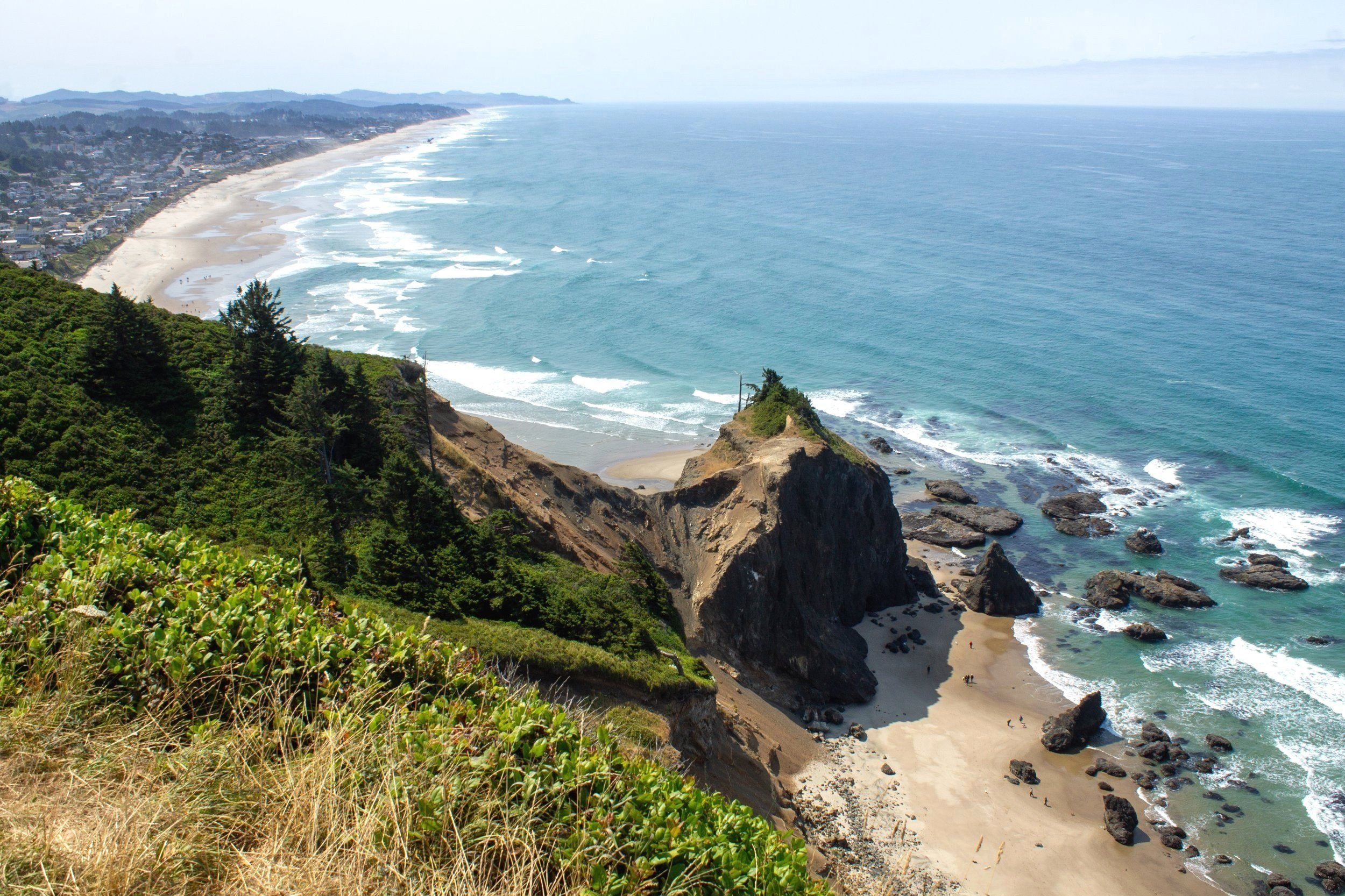
At the top of the Thumb, ocean views surround you in three directions. Four hundred feet below is Lincoln City’s secret beach, a protected cove with many rugged sea stacks. At low tide, you’ll see tiny-looking people on the beach admiring the tidepools. The tide blocks access to this beach at other times. Beyond the small pointed headland of Road’s End Point is Lincoln City’s long and scenic coastline.

Road’s End Beach and Lincoln City from the Thumb
After admiring the views from the Thumb, head back the way you came. When you reach the trail junction, take a left to finish the Knoll loop hike and return to the parking lot. The rest of the journey is a shady downhill walk through the woods.

Red elderberry hangs over the trail
Getting there
Villages Trailhead:
From Highway 101, turn onto NE Devils Lake Blvd (right turn if you’re coming from the north, left from the south). Continue 1.2 miles on NE Devils Lake Blvd. Look for parking on the right side of the road.
Sal de la Sea trailhead:
From Highway 101, turn onto NW Logan Rd. In one mile, turn right onto NE Sal de la Sea Dr. Continue on Sal de la Sea Dr for 0.7 miles until it ends at NE Port Dr, then look for parking on the right side of the road. Don’t park on NE Port Dr. Continue on foot to the end of NE Port Dr to find the trailhead.
Explore nearby

Visit Lincoln City’s secret beach beneath the Thumb.

Head south to visit Devils Punchbowl State Natural Area.
