

16 Incredible Places to Admire Oregon’s Geology
Oregon’s history is full of tectonic collisions, volcanic explosions, lava flows, and glacial floods. Living here has made me a confirmed geology nerd who regularly wears out my friends and family by speculating at length about how rocks formed. So now it’s your turn. Here are my favorite places to admire Oregon’s canyons, waterfalls, and mountains, listed roughly from west to east. On your next vacation or day trip, consider checking out one of these scenic places where you see the wild and wonderful geology of Oregon.

Metamorphic sea stack at Bandon Beach
Some useful terms
Basalt: a volcanic rock made from runny, low-silica lava. Think of far-reaching lava flows rather than explosions.
Columbia River Basalt Group (aka flood basalt): basalts originating from a series of lava flows that erupted from fissures in northeastern Oregon and southeastern Washington, mostly around 14-17 million years ago. These fissures created an enormous amount of lava that flowed across Oregon and reached the Pacific Ocean. Flood basalts are everywhere in Oregon and also in many parts of Washington. Picture someone tripping in the kitchen while carrying a pot of tomato soup. The soup spills onto the floor, the counters, under the stove, you name it. Flood basalts are the spilled soup of Oregon.
Andesite: rock made from medium-viscous, medium-silica content lava that is more explosive than basaltic lava. Common in the Cascade Mountains.
Rhyolite: rock made from viscous lava with high silica content that tends to be very explosive.
Tuff: rock made from ash and pumice of a volcanic explosion.
1. Cannon Beach

Sea stacks seen from Ecola Point
Where to go: The town of Cannon Beach is on the northern Oregon Coast about 90 minutes west of Portland. Its jagged sea stacks are visible from anywhere along the beach. Some of the best views are from Ecola State Park on the north end of town, where you can see the coastline from above.
When to go: Cannon Beach is a great year-round destination. The weather is often best in summer, although it will also be the most crowded this time of year.
Pass required: None to visit Cannon Beach. There is free public parking in town. If you visit the viewpoints and hiking trails of Ecola State Park, you’ll need the Oregon State Park Pass ($5/day or $30/year).
Dog friendly: Yes
The geology: Cannon Beach is known for its sea stacks. These distinctive offshore rocks are made of Columbia River Basalt that formed when lava pouring out from fissures in northeastern Oregon flowed an incredible distance across the state to reach the coast.
The most famous sea stack at Cannon Beach is the 235-foot Haystack Rock, which is thought to have formed around 15 million years ago when basaltic lava pooled offshore and rose upward through soft sedimentary soils. Over thousands of years, Haystack Rock and the nearby sea stacks were uplifted to their current positions. You can walk up Haystack Rock at low tide, although the rock itself is a protected habitat for nesting sea birds.
To the north of Cannon Beach, you’ll see Ecola State Park on Tillamook Head. Ecola Point in the park is an unforgettable viewpoint that looks onto Cannon Beach from above. Columbia River Basalts reached here as well and became interbedded with sandstone. Unlike the basaltic sea stacks, sandstones and shales at Ecola Point make the headland prone to landslides. You’ll see signs near the viewpoint warning you to stay away from unstable areas.
How to see it: You do not need to hike to admire the headland and sea stacks around Cannon Beach but there are great trail options.
Walk along Cannon Beach’s 4 miles of sandy coastline.
Take the 2.5-mile out-and-back trail from Ecola Point to Crescent Beach.
The 3-mile Clatsop Loop Trail leads from Indian Beach to an impressive viewpoint of Tillamook Rock Lighthouse on a basalt sea stack.

Haystack Rock
2. Devils Punchbowl State Natural Area

Inside the Devils Punchbowl
Where to go: Devils Punchbowl State Natural Area is on the central Oregon Coast, about one mile away from Highway 101 between Depoe Bay and Newport.
When to go: The Devils Punchbowl is a great year-round destination. The churning water in the punchbowl will be most dramatic at high tide. Visit at a very low tide to hike down into the Punchbowl.
Pass required: None. Make sure to park in designated public parking.
Dog friendly: Yes
The geology: The Devils Punchbowl is a cavernous depression in a sandstone cliff. It is thought to have formed when a sea cave collapsed. An arch in the sandstone cliff allows seawater to enter the Punchbowl, where it churns and froths against the sides of the bowl. The water recedes at low tide, exposing the bottom and sides of the Punchbowl.
How to see it: There is a viewpoint next to the public parking lot at the end of 1st Street that overlooks the Devils Punchbowl from above.
You can also hike from down into the Punchbowl only during low tide. Proceed with caution if you choose to go inside since it can be dangerous if water enters the Punchbowl. Look for negative numbers on a tide table.
3. Cape Perpetua

Cape Perpetua
Where to go: Cape Perpetua is a few miles south of the town of Yachats on the central Oregon Coast.
When to go: Year-round. Visit at low tide to look for tidepool life. High tide is the best time to see waves crash against the cliffs. Learn more in my article on visiting Cape Perpetua by the tide.
Pass required: Cape Perpetua has a $5/day fee. You can use the Northwest Forest Pass, America the Beautiful Pass, or Oregon Pacific Coast Passport.
Dog friendly: Yes. Dogs must be on a leash in Cape Perpetua Scenic Area.
The geology: The coastline around the town of Yachats is covered with dramatic cliffs and headlands. Like the cliffs on the northern Oregon Coast, you’ll find plenty of basalt here although that is where the similarities end. The rock around Yachats, known as the Yachats Basalt, is around 30 million years old and came from volcanic activity near the coast rather than traveling across the state from the east.
Just a few minutes south of town, Cape Perpetua is a great place to admire coastal geology. The rugged coastline here has some strange and unusual features. Look for the Devil’s Churn, a narrow inlet carved from layers of basalt, where waves enter and crash violently against the walls of the channel. As waves recede, look for orange and purple sea stars clinging to the rocks just above the water line. Watch water fill a bowl-shaped hole called Thor’s Well, where it bubbles over explosively at high tide. Wait for the geyser-like jet of water from Spouting Horn to send a fine mist high into the air.
How to see it:
Drive up to Cape Perpetua Day Use Area where you can admire the coastline from 800 feet of elevation.
Take the 0.8-mile Captain Cook Trail from the Cape Perpetua Visitor Center to walk on the rocks and get close to the water. This trail is the best way to see the geologic features like Devil’s Churn as well as tidepool life at low tide.
4. Bandon Beach

Bandon Beach
Where to go: Southern Oregon Coast
When to go: Year-round. You’ll be able to see some incredible intertidal life on the sea stacks if you visit at low tide.
Pass required: None
Dog friendly: Yes
The geology: Bandon Beach has some of the most interesting sea stacks on the Oregon Coast. They also have a completely different geologic story than those of Cannon Beach. Forget flood basalt. Bandon Beach’s sea stacks are mostly sandstone, although you can find several rock types including blueschist and greenstone. These sea stacks are also about ten times older than those of Cannon Beach, being mostly from the Jurassic Age.
The sea stacks at Bandon Beach are surprisingly accessible. At low tide, you can walk up to dozens of them. When you do, you’ll see that they are encrusted with intertidal life from sea stars to anemones to barnacles. Look for the distinctive pinnacle of Wizard Hat, the upturned face of Face Rock, and the large sea arch near Coquille Point.
How to see it: Bandon has excellent viewpoints overlooking the beach from above. Check out Face Rock State Scenic Viewpoint and Coquille Point.
To admire the sea stacks up close, you can walk along the beach at a falling tide for a 4-mile out-and-back walk. At the north end of Bandon, you’ll reach South Jetty Park, which is constructed from blueschist boulders.

Face Rock at Bandon Beach
5. Elk Rock Island

Waverly Basalt of Elk Rock Island
Where to go: Elk Rock Island is in Spring Park Natural Area in the town of Milwaukee, Oregon, just outside of Portland. Park on the street near Spring Park and follow the hiking trail down the hill to reach Elk Rock Island.
When to go: You can only reach Elk Rock Island on foot when water levels are low in the Willamette River, usually from spring to fall.
Pass required: None
Dog friendly: Yes, leashed dogs are welcome in the park.
The geology: Elk Rock Island is remarkable for having the oldest exposed bedrock near Portland. While basalts younger than 20 million years old from the Columbia River Basalt Group are common in the area, Elk Rock Island is made of 40 million-year-old Waverly Basalt, which is similar to the Tillamook Volcanics of the Oregon Coast. You can see this ancient basalt both on the island and forming Elk Rock cliff across the Willamette River.
Unless you have a boat, Elk Rock Island is a seasonal excursion. When river water levels are low, a land bridge forms from the shore of Spring Park, making Elk Rock Island accessible on foot. The island supports a surprising variety of plants in its small area, including several rare species.
How to see it: To reach Elk Rock Island, you’ll need to hike about 0.5 miles from the entrance at Spring Park. You can also hike around and on top of the island for a total distance of about 1.3 miles.
Learn more about visiting Elk Rock Island here.
6. Columbia Gorge and the Yakima Fold Belt

Coyote Wall from the Mosier Twin Tunnels Trail
Where to go: The Columbia Gorge has fascinating geology from start to finish, but the best place to appreciate the Yakima Fold Belt is between Hood River and The Dalles.
When to go: Year-round. Late spring and early summer are the best time to see wildflowers.
Pass required: Variable. Check individual trailhead requirements.
Dog friendly: Yes, mostly. Dogs are allowed almost everywhere in the Gorge but check specific trail regulations before visiting.
The geology: Several geologic events helped form the jaw-dropping contours of the Columbia River Gorge. Multiple lava flows of Columbia River Basalts came down the old path of the Columbia River, covering the area with flood basalts around 15-17 million years ago and changing the course of the river. Then, massive floods of glacial meltwater tore through the new river channel around 15,000 years ago.
Some of the most interesting rock features visible in the Columbia Gorge are part of the Yakima Fold Belt, an area of compression in the Earth’s crust where Oregon is thought to be rotating clockwise towards a more stable Washington. This rotation creates folds called synclines and anticlines that look like diagonal cliffs. Look for them on both the Oregon and Washington sides of the Gorge.
How to see it: My favorite place to appreciate the contours of the Yakima Fold Belt is the Mosier Twin Tunnels Trail.
7. Silver Falls State Park

Trail behind South Falls
Where to go: Silver Falls State Park is about 30 minutes east of Salem.
When to go: Year-round. Summer is the most crowded season. Winter occasionally sees icy trail conditions. Some waterfalls are seasonal and dry up during late summer.
Pass required: Oregon State Park Pass required ($5/day or $30/year).
Dog friendly: Sort of. Dogs are allowed on some trails but not the ones that have most of the park’s waterfalls.
The geology: Water draining from the Cascade Mountains creates the 14 magnificent waterfalls of Silver Falls State Park. There are four waterfalls you can walk behind, which is the best and most exciting way to admire the geology of Silver Falls up close.
The rock behind the falls is mostly from the Columbia River Basalt Group, but originates from two different lava flows separated by millions of years. Between the two thick basalt layers is a 20-foot layer of sedimentary rock made of river deposits and the remains of a forest that existed before the arrival of the second lava flow.
Unlike the basalt layers, this sedimentary rock erodes easily, forming deep recesses in the cliff faces behind the North and South Falls. The basalt above the sedimentary layer does not erode as quickly but does become less stable as the layer below it crumbles. Boulders at the base of the falls show how chunks of basalt broke off and fell after losing support from below.
How to see it: There is a viewpoint at the top of South Falls, one of the most impressive waterfalls in Silver Falls State Park, which does not require any hiking. You also have the choice of several excellent hiking trails.
The Trail of Ten Falls is a 7-mile loop hike that connects 10 of the park’s waterfalls.
There are connecting trails in Silver Falls that allow for shorter hikes that still include waterfalls. Check out the options here.
Upper North Falls is a dog-friendly waterfall. You can reach it by taking a 0.6-mile out-and-back trail from the North Falls Day Use Area.
8. Cascade Mountains

Mt. Hood and the Sandy River
Where to go: The Cascade Mountains cross through the state of Oregon just east of the Willamette Valley, extending into Washington and British Columbia to the north and California to the south.
When to go: Potentially year-round. Visit in summer or early fall to avoid the snow.
Pass required: Check individual trailhead requirements. Northwest Forest Pass is often required.
Dog friendly: Usually, yes. Check individual trail guidelines.
The geology: The Cascade Mountains are a chain of active volcanos formed by the subduction of the Juan de Fuca oceanic tectonic plate under the North American continental plate. As the oceanic plate moves downward toward the mantle, it warms and releases water. The water then rises toward the continental plate, lowering the plate’s melting temperature and creating magma.
The Cascades range from broad shield volcanoes with runny lava to tall, explosive stratovolcanoes. There are three peaks over 10,000 feet, the highest being Mt. Hood at 11,249 feet. The rock of the Cascades can be basalt, basaltic andesite, andesite, dacite, and sometimes even rhyolite. Glaciers have helped shape the Cascades into their present form by carving some of their most beautiful features like deep valleys and alpine lakes.
How to see it: Where to start. To keep the scope from getting out of hand, here are a few cool viewpoints where you can see Cascade peaks:
Sherrard Point on Larch Mountain overlooks five Cascades peaks, including three in Washington. You can drive up the mountain and reach Sherrard Point by a 0.6-mile out-and-back hike from around June - November.
The Whychus Overlook near Sisters, Oregon, looks onto the Three Sisters and Broken Top. You can reach it by a 1-mile loop hike.
The Dee Wright Observatory to the west of Sisters, Oregon, is surrounded by lava fields and has views of Mt. Washington, Mt. Jefferson, Mt. Hood, and the Three Sisters on a clear day. The observatory closes in winter.
Drive up to Timberline Lodge and check out views from Mt. Hood.

Mt Hood from Sherrard Point
9. Smith Rock State Park

Look for tuff formations on the right side and left background, the left foreground is a basalt bench
Where to go: Smith Rock State Park is in central Oregon in the town of Terrebonne.
When to go: Spring and fall are probably the best times to visit. Both the heat and the crowds will be less intense than in summer. Icy conditions are common in winter.
Pass required: Oregon State Park Pass required ($5/day or $30/year).
Dog friendly: Yes, leashed dogs are welcome in the park.
The geology: The unique landscape of Smith Rock State Park is a product of two different volcanic events separated by millions of years. The first was an explosion 29 million years ago that formed Smith Rock’s dramatic spires of volcanic tuff and created a massive caldera that extends past Prineville.
Weathering over the years has contributed to the fascinating and beautiful appearance of the tuff today. It is worth examining up close on the hiking trails, where you can see rocks of brick red, yellow, pale green, and even lavender. Look for fragments of sedimentary bedrock lodged in the tuff, which broke apart during the explosion.
The second volcanic event is much more recent. Around 400,000 years ago, basaltic lava from Newberry Volcano traveled close to 40 miles to reach Smith Rock. This lava formed a broad, flat basalt bench across the Crooked River Canyon from Smith Rock. When you park at Smith Rock State Park, you will be parking on this bench.
How to see it: While the views from the parking lot are excellent, Smith Rock State Park also has many fantastic hiking trails that get you closer to its incredible geology.
Check out my detailed guide to the hiking trails of Smith Rock State Park here.

Tuff formations on the Misery Ridge Trail
10. Newberry National Volcanic Monument

Big Obsidian Flow
Where to go: Newberry National Volcanic Monument is in central Oregon about 20 minutes south of Bend.
When to go: Spring - fall to avoid the snow.
Pass required: Northwest Forest Pass required ($5/day or $30/year).
Dog friendly: Mostly, yes. The Big Obsidian Flow has sharp rocks and is not a good trail for dogs.
The geology: Newberry Volcano is a young volcano that has produced some of Oregon’s most recent eruptions, including one only 1,300 years ago. It also has unusually diverse and somewhat baffling geology. My visitor’s guide from the US Forest Service describes Newberry National Volcano Monument as having the widest variety of volcanic features of any US park, a boast that is easy to believe when visiting.
Newberry has hundreds of cinder cones, a one-mile-long lava tube, and a lava flow of pumice and obsidian, known as the Big Obsidian Flow. Within Newberry’s huge caldera, there are two lakes and the picturesque twin waterfall, Paulina Creek Falls. Look for tree molds near the hiking trails that wind through the lava rocks of the Lava Cast Forest. Take the shuttle to the top of Lava Butte, a 500-foot cinder cone surrounded by 9 square miles of lava flows.
How to see it: Check out my detailed guide to Newberry National Volcanic Monument here.
11. Cove Palisades State Park

Cove Palisades
Where to go: The Cove Palisades are in central Oregon between Madras and Terrebonne.
When to go: Summer is the most popular season to visit the Cove Palisades, especially if you want to take boats onto the water. The park can be a good year-round destination as winters tend to be mild.
Pass required: Oregon State Park Pass required ($5/day or $30/year).
Dog friendly: Yes
The geology: The Crooked River, Metolius River, and Deschutes River meet at the dramatic canyon of the Cove Palisades. While the rivers are natural, the canyon’s water level is impacted by Round Butte Dam, which created Lake Billy Chinook at the confluence of the three rivers. The vibrant blue of the lake comes as a shock after driving for miles through Oregon’s high desert to reach it.
Basalt forms the impressive canyon walls of the Cove Palisades, sometimes reaching several hundred feet in height. Look for vertical columns of basalt in some of the cliffs. The columnar shape suggests even cooling of the basalt as it formed. The rivers in the canyon continue to erode its walls and you can see evidence of past rockslides.
It’s worth seeking out the Crooked River Petroglyph during your visit. Very little is known about the petroglyph, which is etched onto a boulder near the park headquarters. The boulder was moved from its original location in the canyon to protect it from flooding created by the dam.
How to see it: You can great views of the Cove Palisades from the roads around the park and its day-use area. There are also options to explore beyond the car.
Tam-a-láu Trail is a 6-mile moderate hike that climbs to a viewpoint that looks onto Cascade peaks and the Deschutes and Crooked River Canyons.
Crooked River Rim Trail is a 2-mile moderate hike with great views of the Cascades and Crooked River.
Take a boat out on the water. You can rent boats there from April - October.

Crooked River Petroglyph
12. Painted Hills
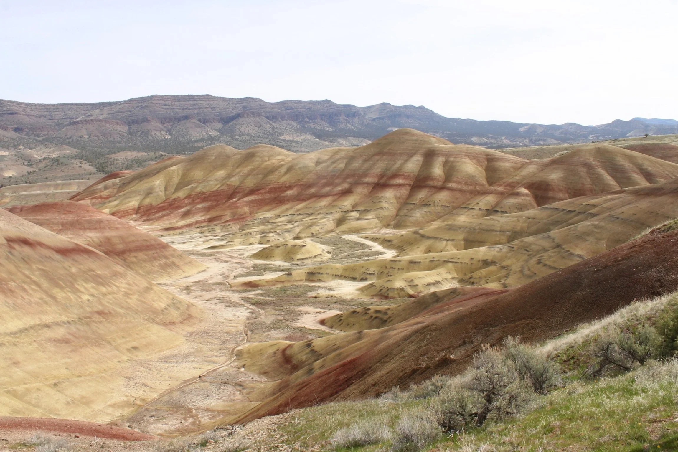
The Painted Hills Overlook Trail
Where to go: The Painted Hills are in central Oregon near the town of Mitchell and about 2 hours east of Bend.
When to go: Visit in April - November to avoid the snow.
Pass required: None
Dog friendly: Yes
The geology: The Painted Hills get their name from the colorful paleosols (ancient, fossilized soils) that form distinct layers in the hills. The paleosols preserve geologic history with unusual clarity. Soils are arranged from oldest to youngest starting from the bottom of the hills, with the oldest soils being around 40 million years old. The colors of the soil layers reflect changing environmental conditions over millions of years.
Iron-rich red soils indicate warm, wet conditions of a subtropical climate. These are generally the oldest soils of the Painted Hills.
Yellow and tan soils reflect drier, cooler conditions more like those of temperate forests.
Dark grey and black soils suggest a wetland environment.
The paleosols of the Painted Hills tell a geologic story about a land where a subtropical climate transitioned to a cooler, drier one as the Cascade Mountains rose, forming a rain shadow over central Oregon. Ash and tuff preserved in the paleosols reflect the volcanic activity affecting the area.
Looking east from the Painted Hills Overlook Trail, you’ll see the Picture Gorge Basalt rising from behind the Painted Hills. These hills are part of the Columbia River Basalt Group and are about 15-16 million years old.
How to see it: While you don’t need to hike to see the Painted Hills, several short trails add a lot to the experience and take you up close to the park’s most interesting geologic features.
Learn more about visiting the Painted Hills and its hiking trails here.
13. Crater Lake National Park

Wizard Island in Crater Lake
Where to go: Crater Lake is in south-central Oregon about 2 hours south of Bend.
When to go: Visit July - September to avoid the snow.
Pass required: A private vehicle pass costs $30 in summer and $20 in winter, which lasts for 7 days. You can also use the America the Beautiful Pass.
Dog friendly: Yes, mostly. Since the rules about bringing dogs are specific and vary by season, read them here before visiting. Briefly, leashed dogs can be in campgrounds, picnic areas, paved roads and trails, and many hiking trails. They cannot go into the lake or on some hiking trails.
The geology: Crater Lake fills the volcanic caldera of Mt. Mazama. Once a mountain thought to be similar to other large Cascade peaks like Mt. Hood and Mt. Adams, Mt. Mazama collapsed into its magma chamber when it erupted around 7,700 years ago. This explosion was massive, sending out many times the volume of magma seen in the 1980 explosion of Mt Saint Helens. Today, Mt. Mazama is considered almost inactive. While there is still some volcanic activity possible, its magma chamber was emptied and geologists do not expect another catastrophic event.
Crater Lake is known for both its depth and clarity. On clear days, light reflected off the lake gives it a remarkable deep blue color. No streams drain into the lake. It is fed by rain and snowmelt. In the center of the lake, look for Wizard Island, a cinder cone that formed after the eruption of Mt. Mazama.
An often overlooked area in Crater Lake National Park is the Pinnacles, a group of rocky spires made of volcanic ash. These hard spires resist erosion and have maintained their distinctive shapes despite weathering. Note the color difference between the top and bottom of the Pinnacles. The lower material erupted first and contains more silica than the darker material at the top.
How to see it: There is a 33-mile road called the Scenic Rim Drive that circles Crater Lake. This road has many viewpoints and trailheads along the way, although sections of it close for part of the year. Late summer into early fall is the time when you have the best chance of accessing the whole loop. You can get amazing lake views all year, although prepare for winter driving conditions from November until around April or May.

Pinnacles at Crater Lake National Park
14. Strawberry Mountains

Strawberry Mountains
Where to go: The Strawberry Mountains are in eastern Oregon close to the towns of John Day and Prairie City.
When to go: July - November to avoid the snow.
Pass required: Check individual trailhead guidelines. NW Forest Pass may be required.
Dog friendly: Yes, although check individual trail regulations.
The geology: The Strawberry Mountains are one of Oregon’s least-known attractions thanks in large part to their remote location. Despite their obscurity, they are a beautiful mountain range notable for having two distinct geologic stories as you move from the east to the west.
The eastern side of the range, known as the Strawberry Volcanics, is made of 12 to 17-million-year-old rocks thought to be related to — once again — the Columbia River Basalt Group, despite being mostly andesite. Here is where you’ll find the range’s highest peak, 9,038-foot Strawberry Mountain.
The western side of the Strawberry Mountains is much older, containing rocks over 200 million years old. These rocks are thought to have once been part of an ancient sea-floor volcanic arc. Gold has been found on this side of the range and inspired mining efforts in the 1800s. Glaciers have impacted both sides of the Strawberry Mountains by carving out valleys and alpine lakes.
How to see it: An excursion out to the Strawberry Mountains is not trivial. They are not close to anything or even on the way to anything. There is a good view of the mountains from Highway 26 around Prairie City, which is as close as I’ve gotten. I’d love to go back someday and try out one of these hikes.
15. Wallowa Mountains

Wallowa Mountains
Where to go: The Wallowa Mountains are in northeastern Oregon near the town of Joseph.
When to go: July - September to avoid the snow.
Pass required: Check individual trailhead guidelines. NW Forest Pass may be required.
Dog friendly: Yes, although check individual trail regulations.
The geology: The Wallowa Mountains have the highest peaks in Oregon outside of the Cascades. The highest is Mt. Sacajawea at 9,838 feet. You’ll also see much older rocks here, with the oldest being almost 300 million years old. These oldest rocks were thought to have formed offshore and then migrated to Oregon through the movement of tectonic plates, adding land to Oregon’s historic coastline. Faults on either side of the Wallowas helped to create the elevation seen in the peaks today.
Much of the Wallowas are made of granite, although you can find plenty of limestones and — I kid you not — Columbia River Basalts. Unlike many areas in Oregon, these Columbia River Basalts did not have to travel by lava flow but instead erupted locally starting around 17 million years ago. The eruption of these basalts may have contributed to the uplift of peaks.
How to see it: There are some serious trails in the Wallowas. When I was looking up hikes ideas, I kept coming across descriptions like, “if you don’t want to do the whole 27 miles, there is an earlier turnaround point for a 16-mile hike.” Great, thanks.
One of the most accessible (although pricey) ways to appreciate the Wallowa Mountains is to take the Wallowa Lake Tramway to the summit of Mt Howard. There are short, easy hiking trails at the top. Or, do what I did, start one of the long trails and turn around early.
16. Hells Canyon

Granny View Overlook on the Hat Point drive
Where to go: Hells Canyon is in eastern Oregon at the Idaho border.
When to go: June - September to avoid the snow.
Pass required: Check individual trailhead guidelines. No pass is required to visit Hat Point.
Dog friendly: Yes
The geology: When measured from the top of the Seven Devils Mountains in Idaho, Hells Canyon is nearly 8,000 feet deep, making it the deepest canyon in the United States and about 2,000 feet deeper than the Grand Canyon.
The oldest exposed rocks in Hells Canyon are at its base, sedimentary and metamorphosed volcanic rock as old as 200 million years that formed offshore and were added to the historic coastline of Oregon through the movement of tectonic plates. Lying overtop these ancient rocks are thick layers of, inevitably, Columbia River Basalts. Two different lava flows deposited flood basalts here before the canyon formed.
The formation of Hells Canyon is not well understood and particularly not well understood by me. The easy cop-out answer is that the area was uplifted, which increased the rate of erosion from the Snake River at the base of the canyon. This explanation does not tackle what caused the uplift. As best as I can tell, it remains an open question and an area of active research.
How to see it: Hells Canyon is the hardest-to-reach destination on this list but is well worth the effort. The canyon is huge and no single spot overlooks all of it. One of the best ways to appreciate the scale of Hells Canyon is by making the drive up to Hat Point, a 24-mile gravel road that reaches an overlook with panoramic views of Hells Canyon, the Snake River, the Seven Devils Mountains, and the Wallowas.
Although long, narrow, and steep, the road up to Hat Point is in good condition and doable with a low-clearance vehicle. There are multiple viewpoints along the way and none are disappointing. It takes about 1.5 hours to reach the Hat Point Overlook from the bottom of the hill.

Hat Point Overlook
In summary, the best places to admire Oregon geology are:
Cannon Beach
Devils Punchbowl State Natural Area
Cape Perpetua
Bandon Beach
Elk Rock Island
Columbia Gorge and the Yakima Fold Belt
Silver Falls State Park
Cascade Mountains
Smith Rock State Park
Newberry National Volcanic Monument
Cove Palisades
Painted Hills
Crater Lake National Park
Strawberry Mountains
Wallowa Mountains
Hells Canyon
Enjoy the rocks, mountains, and volcanoes of Oregon!
With love,
Emma
Want more Pacific Northwest geology? Check out Washington’s mysterious Mima Prairie.
References:
Bishop, Ellen. “Strawberry Mountains.” The Oregon Encyclopedia, 29 Apr. 2022, https://www.oregonencyclopedia.org/articles/strawberry_mountains/#.Y9RPmHbMK3A.
Garrett, S., & Youtie, B. (1992). The Painted Hills: Thirty million years of phytogeography.
Miller, Marli Bryant. Roadside Geology of Oregon. Missoula, Montana: Mountain Press Publishing Company, 2014.
Portland Parks and Recreation. Elk Rock Island Natural Area Management Plan, 1995. https://www.milwaukieoregon.gov/sites/default/files/fileattachments/planning/page/42831/elk_rock_island_mp.pdf
Zetner, Nick. “Hells Canyon and the Ringold Formation.” YouTube, Central Washington University. May 5, 2019. https://www.youtube.com/watch?v=wxg6124BpZw.