

12 Best Stops in the Samuel Boardman Scenic Corridor

Disclosure: Post contains affiliate links
The Samuel Boardman Corridor encompasses 12 miles of scenic coastline between Gold Beach and Brookings. Far from any city center, it’s never crowded despite having some of the most stunning beaches, hiking trails, and viewpoints in the Pacific Northwest. Since development is minimal, no beach houses clutter up the views. The flip side is limited signage, rugged trails, and hidden attractions. In other words, it helps to know where you’re going. Here are the best things to see in the Samuel Boardman Scenic Corridor from north to south. Purists might want to skip ahead to #4. I included several stops beyond the corridor’s ambiguous northern boundary because they’re awesome. Enjoy!
1. Cape Sebastian
Hike in: Not for the viewpoints. Hiking trails start here.
Amenities: None
Fee: None
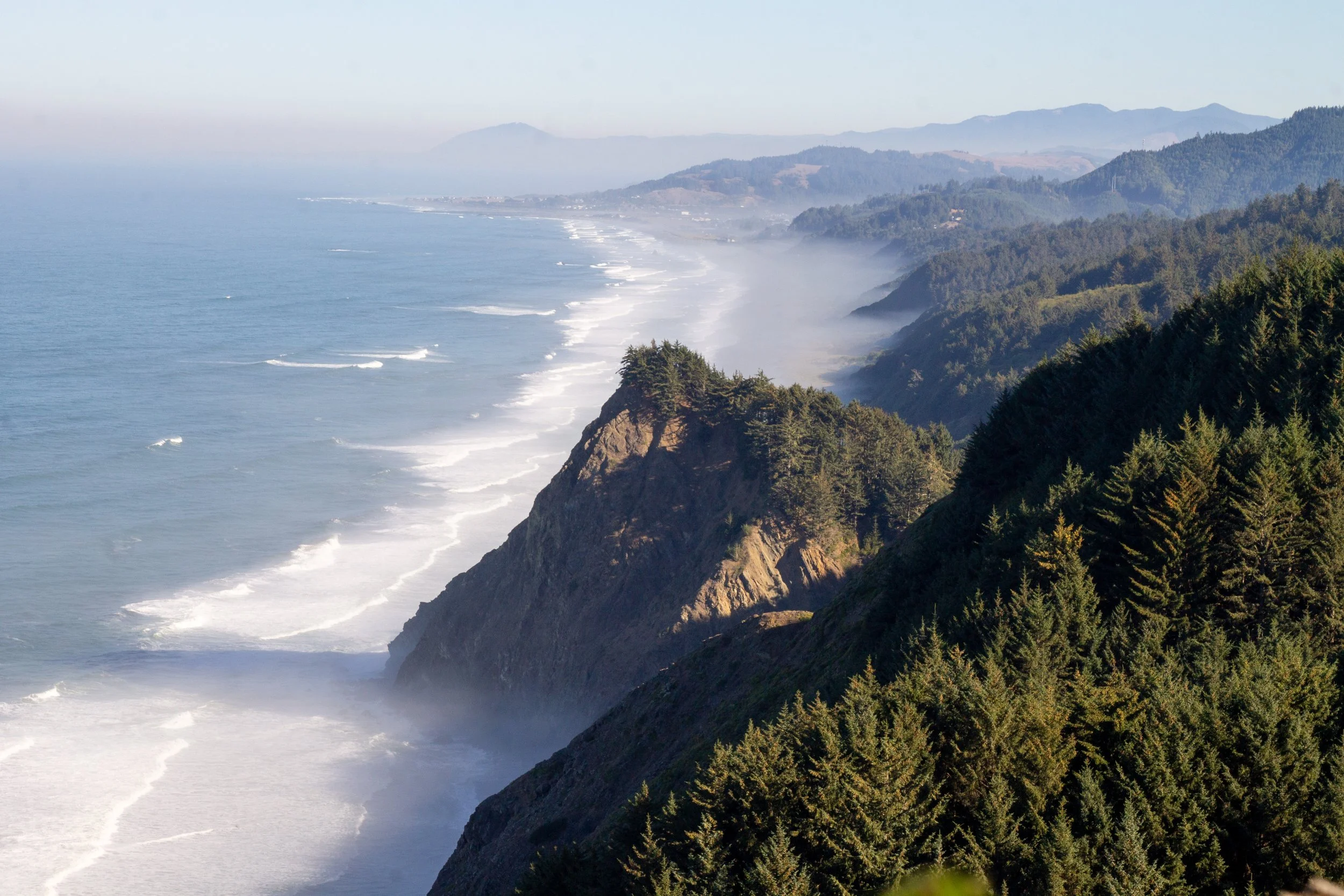
Only a few miles north of the Samuel Boardman Corridor, Cape Sebastian is worth an extra stop. It’s the tallest point you can drive to on the southern Oregon Coast, with viewpoints at the top overlooking the coastline from almost 700 feet of elevation. When a marine layer obscures the views near the water, you’ll be high enough to look down on it from above. On a clear day, you can see from Cape Blanco to Northern California, over 90 miles of coastline. It’s an excellent place for whale-watching, especially during the winter and spring gray whale migrations.
When you turn into Cape Sebastian, you can head towards the north or south viewpoint. If you’re pressed for time, I think the views are better from the south. Neither requires hiking, but I’d recommend walking a short distance on the trail that starts from the south viewpoint. In about 0.1 miles, you’ll reach a better angle to admire the coastline looking north toward Gold Beach. If you have the time and energy, the trail continues down to peaceful and secluded Hunters Cove, a 3.5-mile out-and-back hike. It gets a bit steep, especially close to the beach, and ends with a rope-assisted scramble.
2. Meyers Creek Viewpoint

Hike in: No
Amenities: None
Fee: None
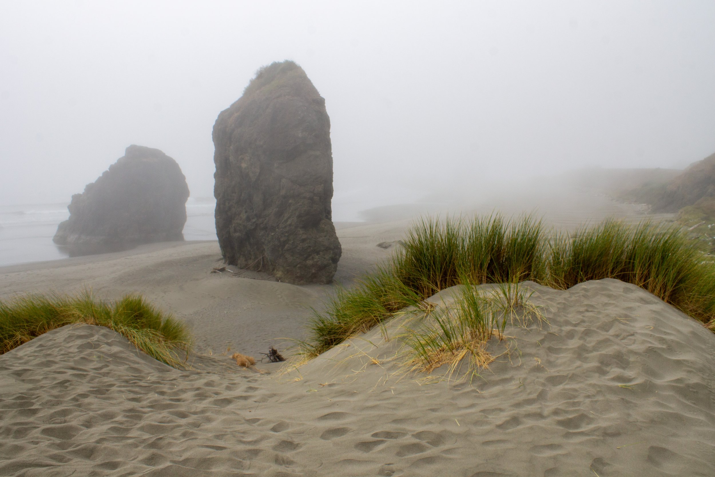
Back at sea level, Meyers Creek Viewpoint is an easy roadside stop with incredible views. You can see it from the road as you drive, but a glimpse of the scenery here tempts many people into an unplanned visit. Rugged sea stacks decorate the sandy beach made of short, truncated dunes. You may recognize the sea stacks from tourist brochures. It’s a destination that draws photographers, especially in the mornings and evenings. At low tide, look for tidepool life on the bases of the sea stacks as you explore. At a very low tide, you can walk through a tall sea arch. To the north, the cliffs of Cape Sebastian loom.
3. Pistol River State Scenic Viewpoint
Hike in: No
Amenities: Restrooms and picnic tables
Fee: None
Much like Meyers Creek, the Pistol River State Scenic Viewpoint is an easy stop with big rewards. This sandy stretch of coast next to the mouth of the Pistol River is a favorite among windsurfers. The dunes start getting larger here, and the sea stacks are just as interesting as those to the north. The most striking of them looks like a giant’s tombstone. This beach is a promising place to see animals like shorebirds and otters, especially near the Pistol River. Besides the wildlife, the mouth of the river is a great rock-hunting spot. Look for jasper, agates, and, rarely, petrified wood on the beach.
4. Arch Rock State Park

Hike in: No
Amenities: Restrooms and picnic tables
Fee: None
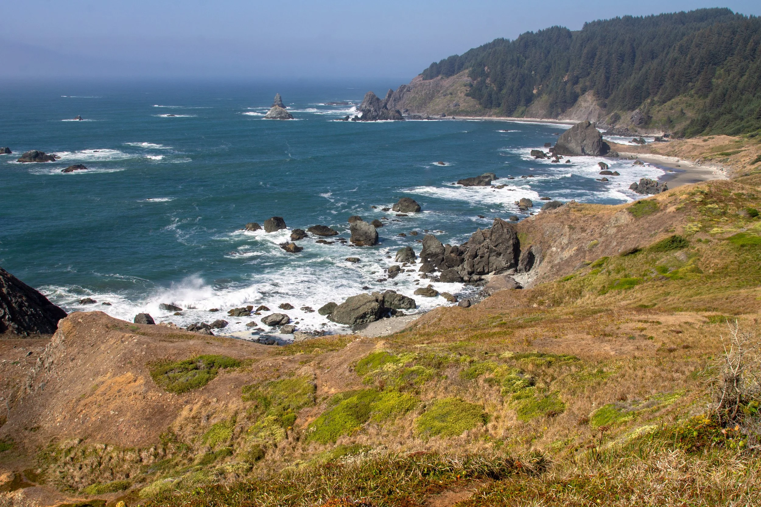
We are now officially in the Samuel Boardman Scenic Corridor, where an incredible introduction awaits. Arch Rock State Park looks like the setting of a fairytale. A short trail circles the top of a coastal bluff, taking you past a series of viewpoints overlooking hidden coves and craggy sea stacks. At the far end of the loop is the park’s namesake, Arch Rock, part of a cluster of rock islands. When fog rolls in, it’s tempting to look for pirate ships and sea monsters hiding out among shadowy rock formations. The amenities at Arch Rock State Park add convenience to the stop. There are benches, shaded picnic tables, and restrooms, not a given in most parts of the undeveloped Samuel Boardman Corridor.
5. Secret Beach

Hike in: 1 mile out and back
Amenities: None
Fee: None
Don’t be fooled by the name. Secret Beach is one of the most popular stops in the Samuel Boardman Corridor. Its remarkable beauty makes it worth visiting regardless. If you decide to tackle this one, allow at least an hour for hiking and beach exploration. A half-mile trail through a mossy coastal forest will bring you to Secret Beach. The trail is in good shape despite some mud, rocks, and roots. The trickiest part comes at the end, a rocky scramble down to the beach. Look for a small waterfall flowing out into the ocean here. At high tide, waves make the sand inaccessible. At low to medium tides, you can walk along the beach, admiring the domed sea stacks close to shore. Look for harbor seals bobbing in the water.
Get detailed directions to Secret Beach.
6. Natural Bridges

Hike in: 0.3 miles out and back
Amenities: None
Fee: None
The parking lot for Natural Bridges Viewpoint is so close to the lot for Secret Beach that you can walk between them. Once you’re at the parking lot, a short, family-friendly stroll leads to the platform overlooking stunning Natural Bridges. These chunky offshore rock arches are among the most famous and photographed sights in the Samuel Boardman Corridor. A trail continues past the platform, but I’d suggest saving your strength for other hikes. Beyond it, the trail ends with an anticlimactic sign warning you about dangerous conditions ahead. People often continue anyway, which is risky and has led to injuries.
7. China Beach

Hike in: 1.2 miles out and back
Amenities: None
Fee: None
China Beach is a place you’ll only find if you’re looking for it. One of the most obscure destinations in the Samuel Boardman Corridor, no signs advertise it from Highway 101 or point the way on a confusing network of trails. If you can overcome the navigation difficulties, the beautiful and deserted beach at the end is a great reward. Start at the North Island Viewpoint parking lot immediately north of the Thomas Creek Bridge (fun fact: Oregon’s tallest bridge). You’ll reach a fork just after the trailhead. The branch to the left leads 0.2 miles to a viewpoint overlooking North Island. The branch to the right will take you to China Beach, one of the prettiest and least visited on the Oregon Coast.
Before going, check out my detailed directions to China Beach.
8. Indian Sands

Hike in: 1-mile loop
Amenities: None
Fee: None
Indian Sands is the most surreal sight in the Samuel Boardman Corridor. What sets it apart is the mix of dunes and rugged sandstone formations. Perched around 100 feet above the ocean, the dunes look like they’ve been transported magically from Florence and dropped onto forested bluffs. Waves have eroded the cliffs into intriguing shapes, including a large sea arch and a small cove where waves enter and crash. The moderately difficult Indian Sands Trail makes a 1-mile loop that will take you through the forest, past the dunes, and along the cliffs before returning to the parking area. Allow at least an hour or two to explore here. Since the trail is close to cliffs along the ocean, it’s not a great destination with small children.
Learn more about the Indian Sands Loop Hike.
9. Whaleshead Beach

Hike in: No
Amenities: Restrooms and picnic tables
Fee: None
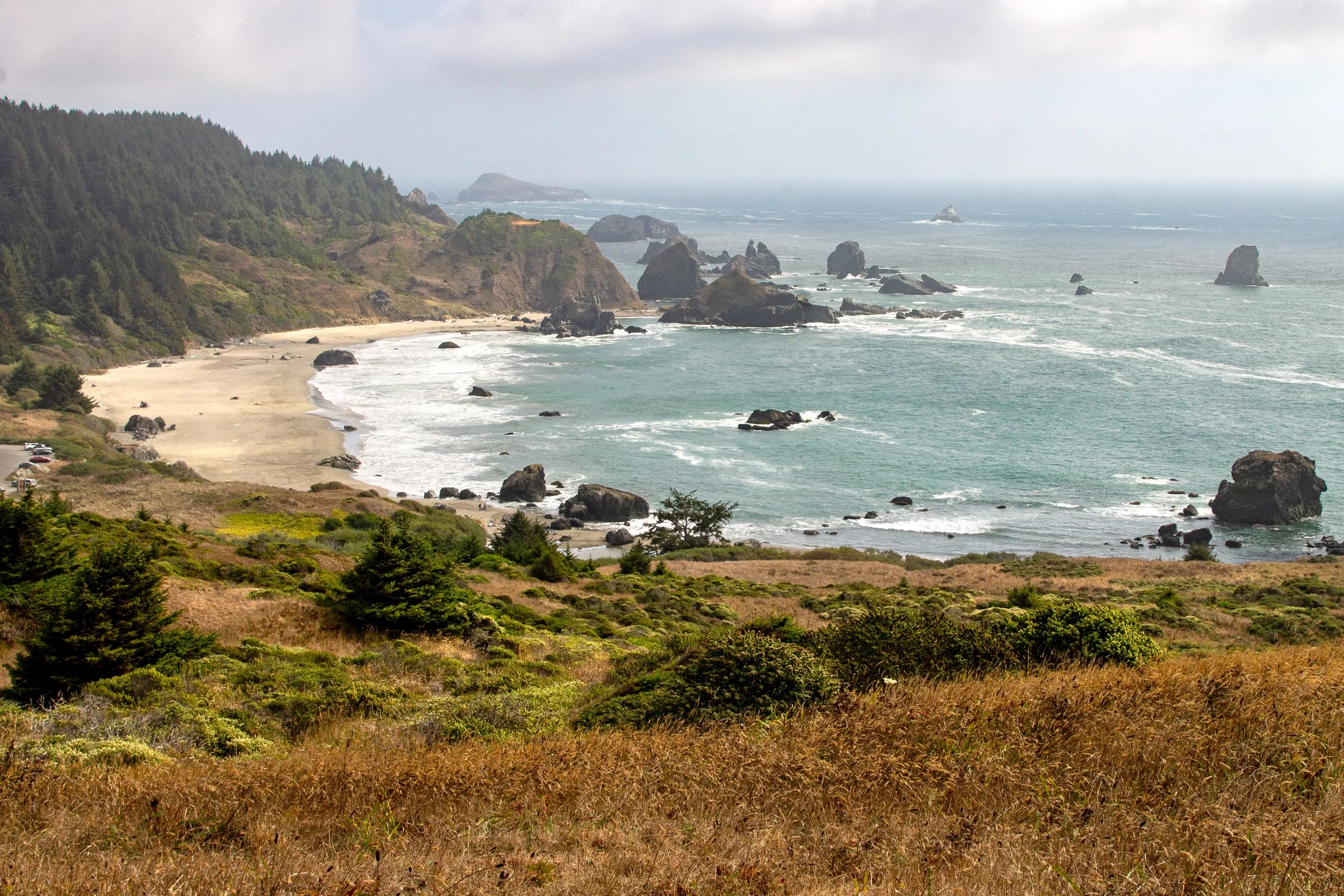
Whaleshead Beach is one of the most convenient beach access points in the Samuel Boardman Corridor. A short drive on Whaleshead Beach Rd will bring you to the parking lot, complete with restrooms and picnic tables. The shortest of trails leads to the water without any hiking needed. The highlight of Whaleshead Beach is a huge rock formation that slightly resembles the head of a whale. Visit at high tide to see puffs of mist shoot out from the top of it like a blowhole. The beach has several other notable sea stacks, impressive cliffs, and plenty of sand for a stroll, even at high tide.
There is also a Whaleshead Viewpoint directly off Highway 101. It’s not a bad stop but, to me, one of the less interesting viewpoints since it’s somewhat overgrown. The beach is a bigger draw.
10. House Rock Viewpoint

Hike in: No
Amenities: Picnic tables
Fee: None
A memorial at House Rock Viewpoint commemorates Samuel Boardman, the first superintendent of Oregon State Parks. True to his vision, the Samuel Boardman Corridor provides access to unspoiled natural spaces with minimal human development. Looking past the memorial, you’ll see views of the Pacific and its craggy coastline. House Rock Viewpoint is along the Oregon Coast Trail. You can drive straight to it or make it part of a hike. The hike from Cape Ferrelo has the added appeal of side trails along the way that lead to beach access.
11. Cape Ferrelo
Hike in: No
Amenities: Picnic tables
Fee: None
Cape Ferrelo can be a quick viewpoint stop or part of a longer hike. If you’re short on time, it’s a place where you can pull off Highway 101 and see sweeping vistas of the Samuel Boardman Corridor’s rugged coast. At the viewpoint, you’ll be about 300 feet above sea level, making it a good spot for whale watching. Several hiking trails begin from the viewpoint. You can make a 1-mile lollipop loop out to the end of the cape. Hiking south will bring you to Lone Ranch Beach (#12 on the list). The trail north leads to House Rock Viewpoint.
12. Lone Ranch Beach
Hike in: No
Amenities: Restrooms and (funny) picnic tables
Fee: None
Like Whaleshead Beach, Lone Ranch Beach is a rare opportunity in the Samuel Boardman Corridor to drive to a beach access point. It’s a place that’s easy to reach but hard to leave. Cliffs along the coastline are a lovely frame for the beach. Densely packed sea stacks provide good tide pooling at low tide. Walking south, you can find a bonus beach area with even fewer people than the main beach. Hiking trails from Lone Ranch Beach theoretically lead to Cape Ferrelo, although they’re hard to find. It’s easier if you start the hike on Cape Ferrelo and head down.
Getting there
The Samuel Boardman Corridor is in a remote part of the southern Oregon Coast. You’ll need a car to get there and explore the stops. The closest airport is in Medford, about 2.5 hours away. It’s 6 hours from Portland or 7 from San Francisco.
Packing list
Since the Samuel Boardman Corridor has few amenities, plan to be as independent as possible when visiting. Here’s what to bring.
Day pack. I like bringing an insulated cooler backpack to have the best beach picnics.
Snacks and water bottle
Camera

Best stops in the Samuel Boardman, summary:
Cape Sebastian
Meyers Creek Viewpoint
Pistol River State Scenic Viewpoint
Arch Rock State Park
Secret Beach
Natural Bridges Viewpoint
China Beach
Indian Sands
Whaleshead Beach
House Rock Viewpoint
Cape Ferrelo Viewpoint
Lone Ranch Beach
Enjoy your trip to the Samuel Boardman Scenic Corridor!
With love,
Emma
Explore nearby

Find the best things to do in Brookings, Oregon.

Explore Harris Beach State Park.


