

4 Magnificent Short Hikes at Crater Lake National Park (+ Quick Visitor’s Guide)

Only 7,700 years ago, a huge volcanic eruption transformed the towering peak of Oregon’s Mount Mazama into a gaping hole in the earth, the Crater Lake caldera. Despite the geologic violence of its creation, Crater Lake today is a peaceful place where deep, clear water often reflects a remarkable sapphire-blue color. A 33-mile scenic byway circles the rim of the Crater Lake caldera and will bring you to unforgettable viewpoints and hiking trails. For help knowing where to start, I picked out my favorite short hikes in Crater Lake National Park, chosen for both scenery and variety. Here is everything you need to know to start planning your trip.

Know before you go
You need an entrance pass to visit Crater Lake National Park. You can buy one when you enter the park for $30/private vehicle ($20 in winter), which is good for 7 days. You can also enter using the America the Beautiful Pass ($80/year) or park-specific Crater Lake annual pass ($55/year).
Dogs are allowed at Crater Lake National Park but must stay in specific areas of the park. In general, parking lots, paved roads, and viewpoints are okay but indoor areas, water sources, and most hiking trails are not. Service dogs are welcome whenever visitors can go. The rules about pets at Crater Lake are specific. Learn the details on the National Park Service’s website here.
Crater Lake gets heavy snowfall during winter. Many areas of the park are inaccessible for part of the year, including most hiking trails. Visit from July - October to avoid the snow.
Bring plenty of water. If you need more, head to the Rim Village or the Mazama Village.
There are restrooms spread throughout the park. If you are entering from the north, the first will be a couple of vault toilets just past the entrance booth. From the south, look for them at Mazama Village.
It’s best to get gas before arriving, but if you find yourself in a pinch, you can refuel at Mazama Village at the south end of the park. You can also find some supplies and grocery items here.
1. Rim Trail

Llao Rock
Distance: 0.5+ miles out and back
Elevation gain: Variable but nothing intense
Difficulty: Easy to moderate
Dog friendly: No, dogs are not allowed on the trail. They can be on paved walkways around viewpoints. For the best lake views with your dog, head to the Rim Village Promenade.
ADA access: No, not beyond some of the viewpoints.
Highlights: Great views of Crater Lake, Wizard Island, and the caldera’s rim with little obstructing tree cover.
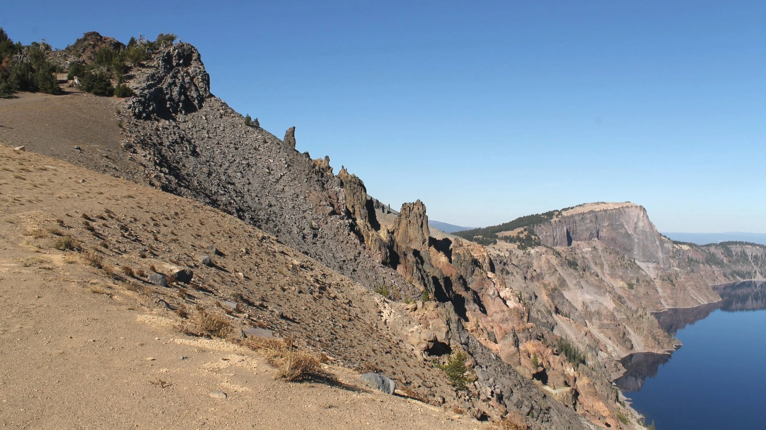
Rim Trail
After the long drive to Crater Lake, chances are you’ll be eager to get out of the car, stretch your legs, and, most of all, see the lake. If you enter the park from the north, the first lake views you can reach are along the Rim Trail and its viewpoints. You can see the lake without hiking, but trying out some of the Rim Trail is a good way to restore circulation after the car journey as well as getting more acquainted with the Crater Lake caldera.

One of the entry points to the Rim Trail
The entire Rim Trail is long and even connects with the Pacific Crest Trail, but you can find amazing views along sections of it done as shorter hikes. It’s a great place to see the gnarled trunks of whitebark pines framing incredible lake vistas. The trail will take you along the west rim of the Crater Lake caldera from Merriam Point (the first place you can see Crater Lake if you enter from the north) to Discovery Point. From here, the Discovery Point Trail continues to Rim Village and Crater Lake’s visitor center. Similar trail, different name.

Wizard Island from the Rim Trail
My favorite way to hike on the Rim Trail is to pull over at a promising-looking viewpoint on Crater Lake’s west side and follow the trail for an arbitrary distance until I start feeling ready to see lake views from a different angle. If you prefer a little more structure, here are some sections of the trail to consider:
Merriam Point is the first place you’ll reach the lake when entering the park from the north. The overlook here has excellent views of Wizard Island and the caldera’s rim, particularly the dramatic cliffs of Llao Rock, which were formed by thick, sluggish rhyodacite lava flows only about 100-200 years before Mount Mazama’s caldera-forming eruption. If you’re facing the lake, head right to take the Rim Trail away from Llao Rock toward the Devil’s Backbone and Hillman Peak. Just go as far as you want, the trail continues for miles.
From the Watchman Trailhead just off Rim Drive, you can make a 1.6-mile out-and-back trek up to the Watchman Observation Station, a two-story lookout tower built in 1932. You’ll gain 400 feet in elevation on the climb up, reaching just over 8,000 feet at the top.
For a longer and likely less crowded journey to the Watchman Observation Station, you can make the 4.8-mile out-and-back hike from Discovery Point to the Watchman. Since this one may be stretching the definition of a short hike, feel encouraged to turn around early if you feel like it. There are excellent views of Crater Lake and Wizard Island along the way that make a partial journey worth it.
Make the easy, 2.2-mile out-and-back hike on the Discovery Point Trail from Discovery Point to Rim Village. You will have multiple opportunities to see the lake along the way. Part of the Discovery Point Trail is paved, starting from Rim Village.
There are short, easy, paved, and rewarding hiking trails around Rim Village, but they are extremely popular and crowded during busy times in the park.

Wizard Island
2. Cleetwood Cove Trail

Benches on the Cleetwood Cove Trail are great for taking in the views
Distance: 2.2 miles out and back
Elevation gain: 600 feet
Difficulty: Moderate
Dog friendly: No, dogs are not allowed on the trail.
ADA access: No, not past the viewpoint at the trailhead.
Highlights: Access to the water and the boat dock at Crater Lake.

The Cleetwood Cove Trail heads down to the water
A generous number of viewpoints surround Crater Lake and provide opportunities to admire it from above, but hiking the Cleetwood Cove Trail is the only way to see its deep blue waters up close. The hike is a steep descent just over a mile long that will bring you from Rim Drive to Crater Lake’s boat dock and the rocky shore beside it. If you are taking a boat tour, this is the trail you’ll use to get there.

The trail ends at the lakeshore
The Cleetwood Cove Trail is tiring but rewarding, with stunning lake views almost the entire way. The beginning of the hike has shady stretches where you’ll see trees growing precariously on top of large boulders next to the trail. The trees thin as you descend, allowing for more views of the water. On a hot day, it is a steep, sunny, and dusty walk down to the lakeshore toward the end. Once you reach the water level, you’ll be able to appreciate the unusual clarity of Crater Lake. If you linger at the lakeshore, there’s a good chance of seeing a salmon or trout swim by.

The rocky shore of Crater Lake
Swimming in Crater Lake:
You can swim in Crater Lake within 100 yards of Cleetwood Cove as long as you don’t bring anything into the lake besides a bathing suit. To protect the unique environment of the lake, items like goggles, wetsuits, flotation devices, and kayaks are not allowed. Expect the water to be cold. Its average temperature in summer is around 57 degrees F (14 C). There is a restroom building at the lakeshore you can use for changing.
Fishing in Crater Lake:
Crater Lake does not have native fish, but rainbow trout and kokanee salmon have survived here after people stocked the lake in the late 1800s and early 1900s. You can fish at Cleetwood Cove and you don’t need a permit. Use only artificial lures. Organic ones are not allowed.
Boat tours:
You can explore Crater Lake at water level by taking a boat tour around the lake or out to Wizard Island. Boat tours depart from the dock at the end of the Cleetwood Cove Trail, so you will need to hike the trail to reach the dock. Be sure to save energy for the return trip. The hike back from the dock to the parking lot is uphill and often steep. People 3 years and older are allowed on tour boats. Reserve tickets ahead of time and learn more at the tour company’s website here.
Learn more about hiking the Cleetwood Cove Trail in my article here.
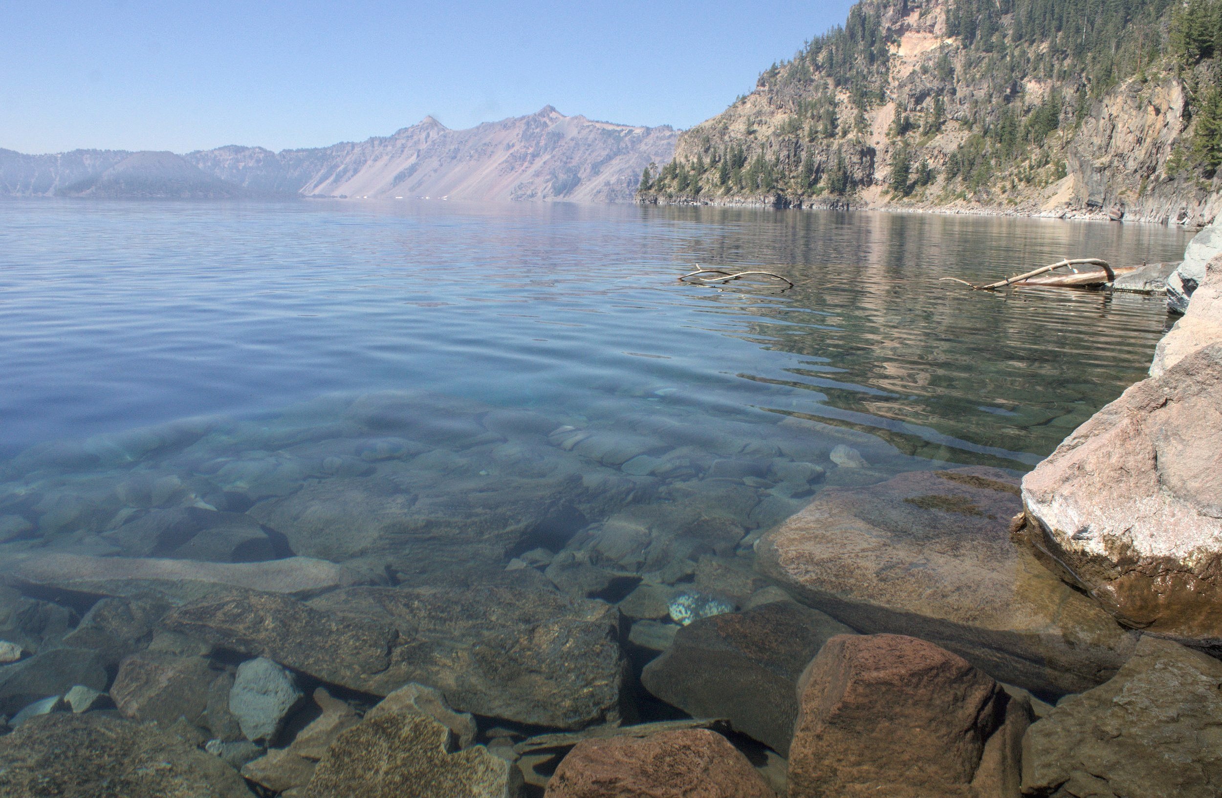
Crater Lake is one of the clearest lakes in the United States
3. Sun Notch Trail

The trailhead
Distance: 0.5-mile loop
Elevation gain: 100 feet
Difficulty: Easy
Dog friendly: No, dogs are not allowed on the trail.
ADA access: The crushed gravel trail is wide, even, and well-maintained, but the grades get steep. It would be challenging, even with assistance, if you use a wheelchair. There are benches on the trail.
Highlights: Excellent views of the Phantom Ship, perhaps the best in the park.
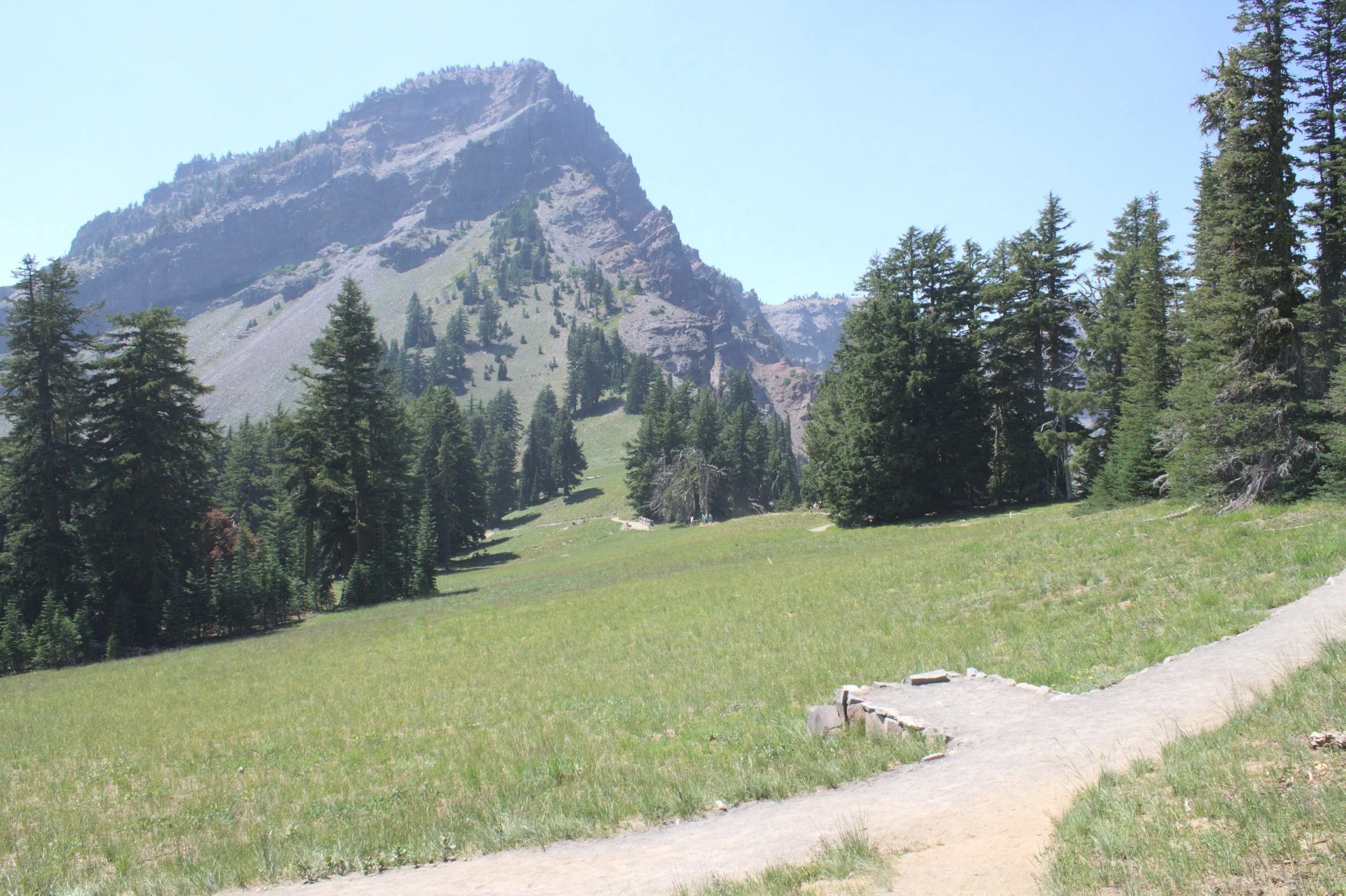
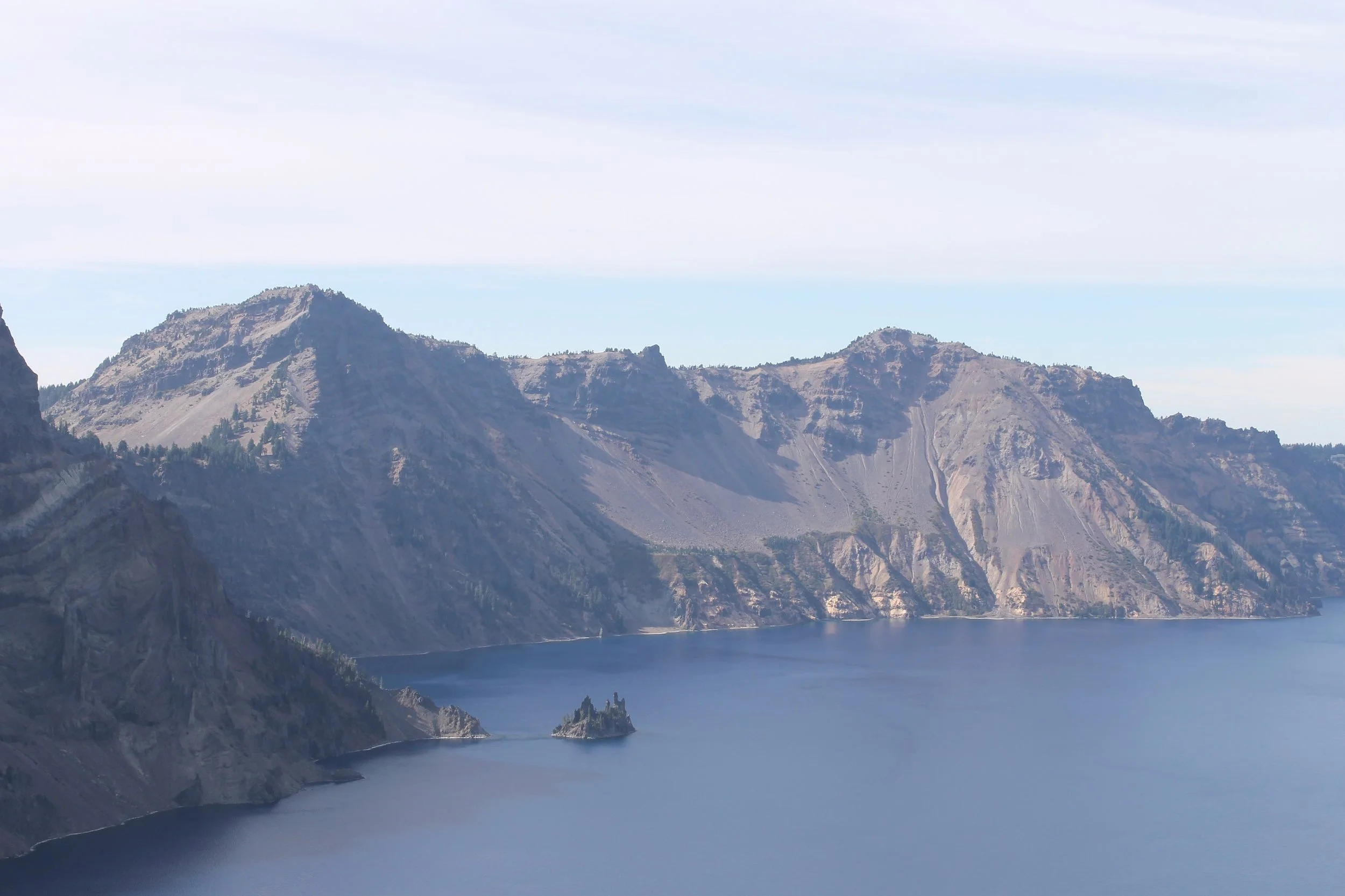
Applegate Peak from the Sun Notch Trail
Just off the southeastern shore of Crater Lake is the Phantom Ship, an island of 400,000-year-old andesite that looks like a marauding pirate vessel. It survived Mount Mazama’s major eruption 7,700 years ago and its rock is among the oldest in the Crater Lake basin. Look for a few tenacious pines growing from its jagged spires. Depending on the light, the angle, and the weather, the Phantom Ship can look very different. Sometimes its gray stone stands out like a beacon on Crater Lake’s vibrant blue water. On a foggy day, it might disappear into the mist.

Phantom Ship from the Sun Notch Trail
While you can see the Phantom Ship from a dedicated viewpoint just off Rim Drive, my favorite views are from the Sun Notch Trail. From the trailhead, you’ll pass through a grove of trees and then reach an alpine meadow with views of Applegate Peak to the west and Dutton Cliff to the east. The trail climbs steadily toward the rim of the caldera but never gets very steep. After about a quarter mile, you’ll arrive at a viewpoint for the Phantom Ship, arguably the best in the park.
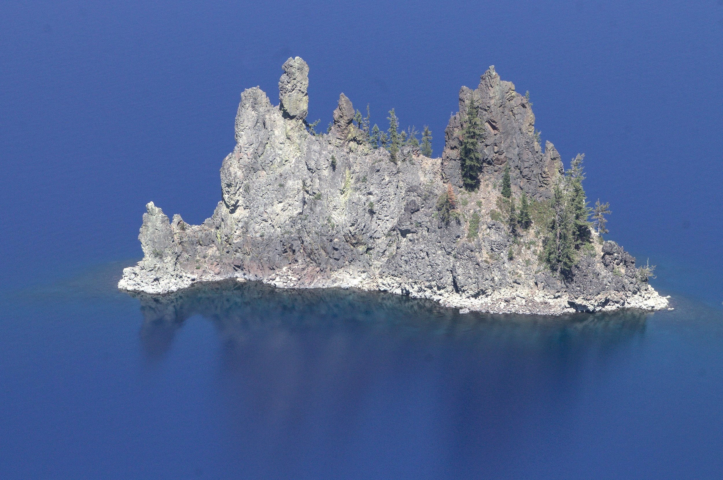
The Phantom Ship
After this first viewpoint, the trail follows the caldera’s rim, allowing for more views of the lake through the trees. Look for wildflowers along the trail in late summer and early fall. Across the lake, you’ll see Wizard Island, Mount Thielsen, and Hillman Peak. After seeing the views from the rim, you’ll head back down the hill to the forest to finish the loop.

Fireweed blooms in front of Crater Lake
4. Pinnacles Trail

Pinnacles of ash-flow tuff next to Wheeler Creek
Distance: 1 mile out and back
Elevation gain: Minimal
Difficulty: Easy
Dog friendly: No, dogs are not allowed on the trail.
ADA access: The crushed gravel trail is wide, flat, and even from start to finish.
Highlights: Volcanic tuff forms strange and unusual spires along a forested canyon.
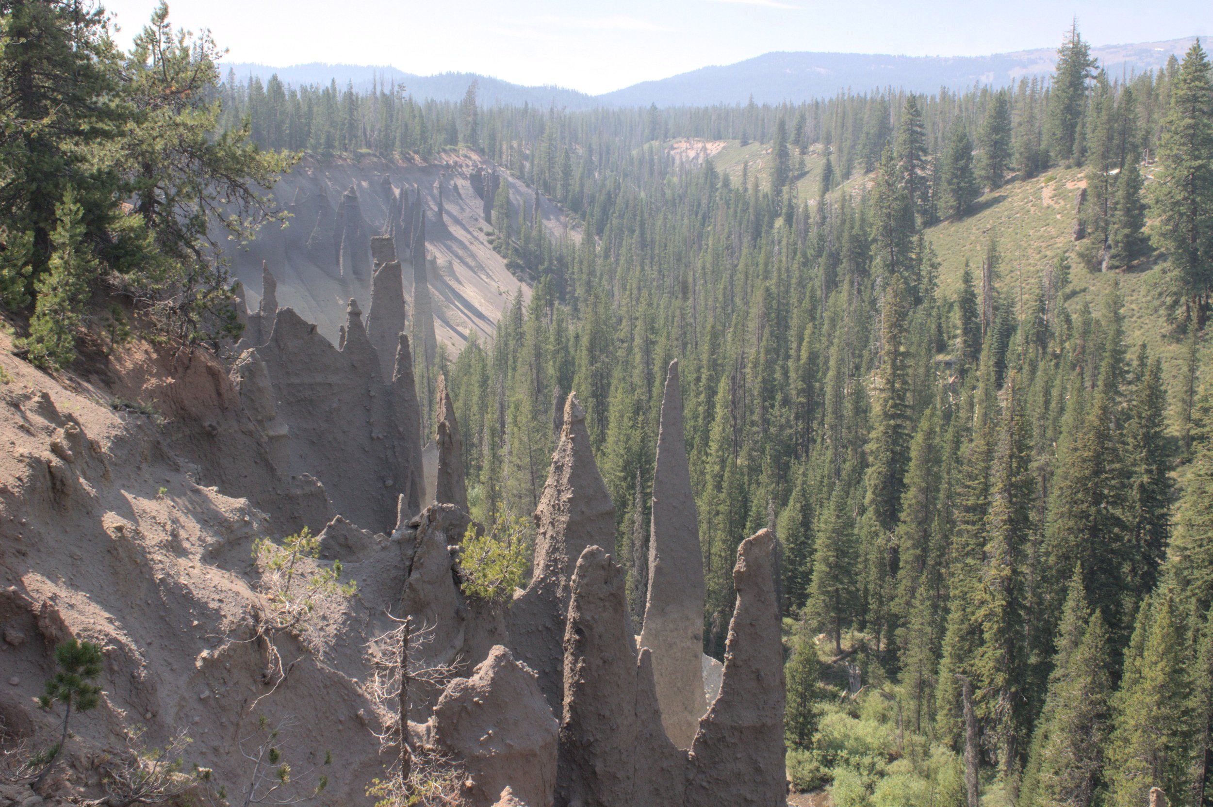
Viewpoint on the Pinnacles Trail
Often overlooked, the short and sweet Pinnacles Trail is one of the easiest and most interesting short hikes in Crater Lake National Park. Here you’ll find spires of eroded volcanic ash-flow tuff on the slopes next to Wheeler Creek, a tributary of nearby Sand Creek. To reach this hike, you’ll need to drive 6 miles away from the lake on a road that ends at the Pinnacles Trailhead. Look for views of Sand Creek and the first glimpses of pinnacles from the car window as you make your way to your destination.

Mount Scott and some pinnacles
Some of the best views of the pinnacles are at the viewpoint next to the trailhead. From here, the hike is a pleasant stroll on a flat, well-maintained trail with shade throughout. Along the way, you’ll pass a couple more viewpoints that are great places to admire rows of pinnacles, Wheeler Creek, and the distant peak of Mount Scott.
Even in a park full of volcanic marvels, the pinnacles are memorable. Their formation began with the eruption of Mount Mazama 7,700 years ago, which filled a glacial valley with a thick layer of ash-flow tuff. Over time, erosion wore away the tuff and created canyons. Along the canyon walls are tall, narrow spires of stronger, more resistant rock that remain after the weaker surrounding rock eroded. These pinnacles owe their strength to the movement of gases in the hot ash as it cooled, precipitating minerals in pipe-like formations.
You’ll notice two distinct color layers in the pinnacles where darker stone sits above lighter stone. The color variation comes from a difference in silica content, with lighter-colored rock indicating more silica. Earlier pyroclastic flows originated higher in Mount Mazama’s magma chamber and had a higher silica content than later, lower-silica flows. In general, more silica means a more explosive eruption.

A sign marks the park boundary and end of the trail
The end of the hike is a bit anticlimactic but has historical significance. You’ll reach a sign indicating the border of Crater Lake National Park, which is where to turn around. This boundary was once the eastern entrance to the national park. A stone structure remains next to the trail that held the sign for the park entrance. The Pinnacles Trail was an access road.
Bonus hike option: On the way road to the Pinnacles Trailhead, you will pass the trailhead for Plaikni Falls. From here, you can begin an easy 2-mile out-and-back hike to a pretty, 20-foot waterfall.
Rim Drive

Rim Drive
A 33-mile scenic byway circles the rim of the Crater Lake caldera, aptly called Rim Drive. It will bring you to the hiking trails as well as many easy pull-offs and overlooks. Rim Drive is paved and in good condition, so have no fears driving on it in a low-clearance vehicle. The road closes seasonally for snow. The exact dates vary based on snow conditions, but most years expect it to be open from late June until mid-October. Allow for about 2-3 hours to drive around the lake. There aren’t any disappointing viewpoints on the road, so feel encouraged to stop often and with great spontaneity. I’ll mention a few highlights here.

Vidae Falls
Vidae Falls is a 115-foot cascading waterfall surrounded by wildflowers. It is the best-known and easiest to reach waterfall in Crater Lake National Park. You can see it from the car window, but if you have time it’s worth taking a few minutes to pull off the road and admire the falls from its base. Although it looks like the water comes from Crater Lake, snowmelt and a small spring feed the falls.

Cloup Cap Overlook
At 7,960 feet of elevation, Cloudcap Overlook is the highest point you can drive to in Crater Lake National Park. The road leading there is also the highest paved road in Oregon. The overlook provides westward panoramic views of Crater Lake, including Wizard Island, Phantom Ship, and Mount Scott. To reach the overlook, look for the turn off of East Rim Drive and follow the road about one mile to the top. There will be plenty of room to park and enjoy the views. Note that the road to the overlook may be closed due to snow into August.

The Phantom Ship, looking more phantasmal than I intended, at the Phantom Ship Overlook
The Phantom Ship Overlook is an easy roadside pull-off that will bring you to views of the Phantom Ship without hiking.
The Rim Village on the south side of Crater Lake has easy, wildflower-lined hiking trails and many amenities for visitors if you can find parking. Honestly, the Rim Village is my least favorite place in the park because of the crowds there. The last couple of times I visited, I gave up on stopping after seeing the teeming hordes. If you are more patient than me (evidence suggests that most people are), look for the historic Crater Lake Lodge, interpretative information, restrooms, a visitor center, a gift shop, a cafe, and about half the population of Oregon at the Rim Village. The Rim Village Promenade is a short, easy trail with great lake views that you can enjoy while walking your dog.
Trolley tours:
You can see the highlights of Rim Drive without driving by taking a trolley tour around the lake. Tours operate from around July until mid-September and last about 2 hours. The trolleys are enclosed and wheelchair-accessible. The tour includes stops at several viewpoints around Rim Drive and time for pictures. A park ranger will lead the tour and provide context for the scenery with information about the park’s nature and history. Note that pets are not allowed on the trolley. Learn more about trolley tours here.
When to visit

Snow lingers at Crater Lake in early July
Crater Lake National Park is open year-round, but Rim Drive closes seasonally due to heavy snowfall. Expect the closure to last from around late October until mid-June. Even after the roads clear, snow may linger at higher elevations into July. Some roads, like the one leading up to the Cloudcap Overlook, may stay closed into August.
Crater Lake’s most popular season is July - September. These months are also the best time to look for wildflowers in the park. Early bloomers like spreading phlox appear shortly after the snow melts. In midsummer, look for a wide variety of blooms like fireweed, lupines, sulfur-flower buckwheat, columbine, and paintbrush. Late bloomers like rabbitbrush will linger into fall before the snow falls again.
Like all of Oregon, Crater Lake sometimes suffers from poor air quality due to smoke from wildfires. You may have noticed a bit of haze in some of my photos. Smoke is most likely in late summer and early fall.
Winter (November - April) is a beautiful time to visit Crater Lake National Park but also means winter driving conditions. The park receives over 40 feet of snow each year and chain requirements are common. Only the park’s west and south entrances are open year-round. The Rim Village is usually open, but Rim Drive is closed in winter past the village. Also be aware that on cloudy days, Crater Lake will not reflect its signature blue color.

Sulfur-flower buckwheat blooms on the rim in August
Geology of Crater Lake
The Phantom Ship in Crater Lake
Crater Lake fills a 5-mile by 6-mile caldera that formed 7,700 years ago after a catastrophic volcanic eruption collapsed the peak of Mount Mazama. Before this eruption, Mount Mazama was one of the tallest peaks in the Cascade Mountains. Its volcanic history began over 400,000 years ago when lava flows started to build its andesite and dacite slopes. Geologists estimate that it reached a height of around 10,000 - 11,000 feet before its collapse.
Mount Mazama’s eruption 7,700 years ago was unlike any of its previous activity. This event was huge and violent, involving explosive rhyolite and far-reaching clouds of ash. The eruption was so large that Mount Mazama’s peak collapsed into its magma chamber, leaving behind a gaping caldera. Rain and snowmelt filled the caldera with time, creating Crater Lake. At 1,943 feet deep, it is the deepest lake in the United States and possibly the clearest. No rivers or streams flow to the lake, which limits the sediment that would cloud its water, all 4.9 trillion gallons of it. Yes, that was trillion with a T.
Around Crater Lake, you can see both older and newer volcanic features. Its oldest island is the Phantom Ship, made of 400,000-year-old andesite. Wizard Island is much younger, having formed only a few hundred years after Mount Mazama’s collapse. Wizard Island is a 2,000-foot cinder cone (measured from its base) that rises 500 feet above the lake. It has a crater at its top, which is the only crater in the park since Crater Lake is in a caldera. Mount Scott is the highest point in Crater Lake National Park and is made of 420,000-year-old dacite.
If you enter the park from the north, you’ll drive through the Pumice Desert on your way to Crater Lake. On either side of the road, a thick layer of pumice covers a vast area that was a glacial valley before Mount Mazama’s major eruption 7,700 years ago. Water drains quickly through this porous rock, limiting the amount available to plants trying to establish themselves here.
Wildlife at Crater Lake

Golden-mantled ground squirrel
Although many animals live in Crater Lake National Park, it may seem like there is only one, the golden-mantled ground squirrel. It is not so much a question of where you’ll see them as where won’t you see them. Lingering at viewpoints and unintimidated by human visitors, these guys will be after your lunch. As with all wildlife, don’t feed or approach them regardless of how cute they are when they approach you. Fair warning, they will be extremely cute. Golden-mantled ground squirrels look a lot like chipmunks but are a bit bigger and don’t have stripes on their faces.
Crater Lake National Park is home to over 70 species of mammals. Besides the ground squirrels, they are mostly pretty shy. Some of the more common sightings are deer, squirrels, rabbits, black bears, coyotes, foxes, and pikas. The park is also a good place to look for birds. In particular, Clark’s nutcrackers, a bird that looks a bit like a gray jay, are often easy to spot in the branches of whitebark pines. You might also see Steller’s jays, woodpeckers, bald eagles, peregrine falcons, common mergansers, and a wide variety of songbirds.
Among Crater Lake’s more unusual animals are Mazama newts, a subspecies of rough-skinned newt that is unique to the lake and its only native species. Mazama newts have darker underbellies and fewer toxins in their bodies than other types of rough-skinned newts. Wizard Island has a population of garter snakes. While not a distinct species, they do show less pronounced stripes than garter snakes elsewhere in the world. Some have no visible stripes at all.

Golden-mantled ground squirrel poses in front of Wizard Island
Getting there
Crater Lake National Park has two entrance roads that will bring you to Rim Drive, one from the north and one from the south. You can buy an entrance pass coming from either direction. If you’re coming from the north (Portland, Bend, Salem, or Eugene), you’ll take North Entrance Road. If you’re coming from the south or west, you’ll pass through Mazama Village on your way to Rim Drive. Note that only the south entrance will be open during winter. The drive from Portland takes about 4-4.5 hours. The drive from Bend will be about 2 hours.
Enjoy your trip to Crater Lake National Park!
With love,
Emma
Explore nearby

Explore another amazing caldera at Newberry National Volcanic Monument.

Check out the best short hikes near Bend.

Find more things to do in Central and Eastern Oregon.

Find more things to do in the Cascade Mountains.
References:
Bacon, Charles R., ed. Geologic map of Mount Mazama and Crater Lake caldera, Oregon. USGS, 2008.
“Crater Lake: The Legacy of Mount Mazama.” Everybody’s National Parks, season 9, episode 3, Spotify.
Miller, Marli Bryant. Roadside Geology of Oregon. Missoula, Montana: Mountain Press Publishing Company, 2014.
For more information about visiting Crater Lake National Park, including updates on closures, visit the National Park Service’s website.