

7 Unforgettable Hikes at Smith Rock (+ Quick Visitor’s Guide)

Smith Rock State Park in Terrebonne, Oregon, is one of those places I would happily visit every day for the rest of my life. One of the seven wonders of Oregon, the towering rock formations in Oregon’s high desert will make any reasonable person’s jaw drop at first sight. The air smells of juniper. Songbirds call from the branches of ponderosa pines. Wildflowers begin to bloom in spring. Although a massively popular climbing destination, one of the best ways to get to know Smith Rock is by exploring the trails. Here are the most rewarding hikes in Smith Rock State Park.

Smith Rock from the Rim Rock Trail
Know before you go
Visiting Smith Rock State Park requires a $10 day pass. You can also use an annual Oregon State Park Pass ($60).
The hiking trails at Smith Rock have very little shade, and summer days get hot. Wear sunscreen and bring more water than you think you’ll need.
Carry water with you while hiking at Smith Rock. Most hiking trails end with a steep, thirsty uphill march back to the parking lot. There’s a water spigot behind the Welcome Center. It wasn’t working when I last visited.
Most hiking trails at Smith Rock are family-friendly. I’ll be specific in the descriptions below.
Leashed dogs are welcome at Smith Rock State Park.
Watch for rattlesnakes, especially when hiking in the morning.
Several restrooms are in the park besides those at the campgrounds. The best one is near the Welcome Center. A composting toilet is near the Crooked River Bridge.
The picnic area near the Welcome Center has some shade.
There are good signs at the trail junctions, but it’s still a good idea to have an offline trail map. You can download one from Oregon State Parks here.
Tent camping at Smith Rock State Park is open from early spring to late fall, depending on the weather. It is first-come, first-served. RVs and car camping are not allowed. For more options, check out nearby campgrounds like Skull Hollow Campground.

The trails have little shade and can get very hot in summer
When to visit
The best hikes at Smith Rock are very popular. The park gets crowded, especially on weekend days when the weather is good.
Spring and fall are usually the best seasons to visit. The days are cooler than the scorchers of summer, and crowds tend to be less overwhelming. Spring is the best time to see wildflowers. In the fall, look for the pumpkin patch near the park.
Summer has many beautiful, sunny days, but it also means heat and crowds. Summer days can get over 100 degrees F, and there’s little shade for protection. It can also be hard to find parking. Weekdays and early mornings are the best times to visit during the summer.
Winter at Smith Rock is the least crowded season and can be beautiful, but it brings potentially hazardous conditions like snow and ice on the trails.
Hiking Trails at Smith Rock
Rim Rock Trail

View from the Rim Rock Trail
Distance: 1.4 miles out-and-back
Elevation: Minimal
Difficulty: Easy
Kid-friendly: Yes, look for the mini climbing wall near the Welcome Center.
Connects to: Rope-de-Dope Trail and Canyon Trail
As soon as you step out of the car, you’ll see Smith Rock looming large across the Crooked River Gorge. The Rim Rock Trail, one of the best hiking trails in Smith Rock State Park, is only a few steps away. This flat, crushed gravel trail runs along the rim of the Crooked River Gorge past the Welcome Center, picnic area, mini climbing wall, and views galore. Look for magpies in the trees as you walk.

Climbing wall on the Rim Rock Trail
The trail has a couple of official viewpoints with benches, but the whole thing feels like one big viewpoint. Trees are sparse on this trail, which has unobstructed views of Smith Rock throughout nearly all of its distance. At several points, the trail gets close to the edge of the basalt plateau, providing views of the Crooked River snaking along the base of Smith Rock. Overlooks are fenced and family-friendly.
As a bonus, the Rim Rock Trail is also one of the few trails in the park that doesn’t require any hill climbing. The gentle grade and even surface of the trail make it accessible with most wheelchairs.
To descend into the canyon, there are two choices:
The main route is the Canyon Trail or Chute Trail near the Welcome Center, which leads down to the Crooked River Bridge and the trail junction for the River Trail, Misery Ridge Trail, and Wolf Tree Trail (see below).
Alternatively, you can take the Rope-de-Dope Trail at the south end of the Rim Rock Trail. It’s a little longer with a gentler slope and eventually meets up with the Canyon Trail near the Crooked River Bridge.
Canyon Trail or The Chute

The Chute Trail
Distance: 1 mile (Canyon) or 0.5 miles (the Chute) out-and-back
Elevation: 170 feet
Difficulty: Easy (Canyon) or hard (the Chute)
Kid-friendly: Yes, going down the Chute Trail is especially popular with kids.
Connects to: Misery Ridge Trail, River Trail, Homestead Trail, Wolf Tree Trail
To reach many of the hikes in Smith Rock State Park, you’ll need to head down into the Crooked River Gorge at the base of Smith Rock. Look for the paved path near the Welcome Center that descends steeply. It’s worth it to take a minute at the viewpoint near the top of the trail that overlooks Smith Rock and Crooked River. A sign there gives a good overview of Smith Rock’s geology. Continue 0.1 miles past the viewpoint, and the trail splits in two. There’s a choose-your-own-adventure element to the hike at this point:
The Chute Trail, branching off to the right, descends sharply 0.1 miles down to the canyon floor and the Crooked River Bridge without switchbacks.
The Canyon Trail to the left ends up in the same place with the addition of a switchback, making it 0.4 miles to reach the bridge. I slightly prefer this trail for being easier on the knees, especially going down, but they end up being pretty similar.
Both trails end at the Crooked River Bridge, the only bridge across the Crooked River. From here, you can take the River Trail or the Wolf Tree Trail to explore the base of Smith Rock, or start heading up Misery Ridge Trail.
Misery Ridge Trail

Misery Ridge Trail
Distance: 2 miles out-and-back (plus Canyon or Chute trail to connect to the parking lot)
Elevation: 1100 feet
Difficulty: Hard
Kid-friendly: Yes, for older children.
Connects to: River Trail, Wolf Tree Trail, Canyon Trail, Mesa Verde Trail (makes this trail a loop, see next), Summit Trail
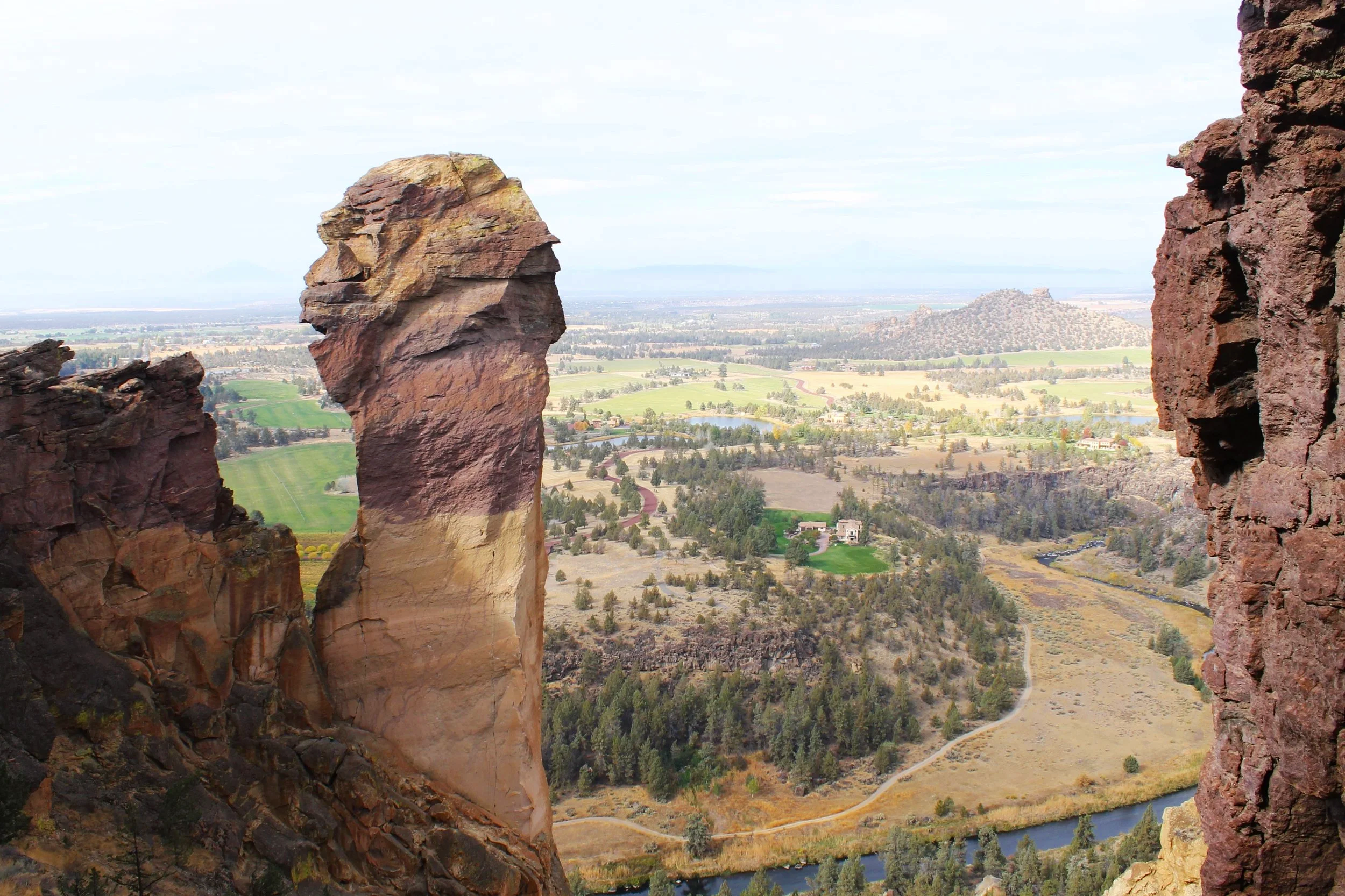
The Misery Ridge Trail is the best known of the hikes at Smith Rock State Park, and with good reason. Not one step of it is boring. It’s a steep and surprisingly challenging 1-mile climb to the summit of Smith Rock. Starting at the Crooked River Bridge, the trail begins the first set of switchbacks up Smith Rock and then begins to wrap around its northeastern face. You’ll pass popular climbing areas, including the striking and aptly-named Red Wall.
Carry on up the switchbacks and stairs to reach the summit of Smith Rock. The views are ample reward for all the huffing and puffing. A ridgeline of spiny peaks extends north, backed by the taller, gentler slopes of Gray Butte. Below is the Crooked River flanked by pine groves. Across the river, you’ll see the basalt plateau that forms the south rim of the canyon.
Continue along the trail on top of Smith Rock to find views of the tuff formation to the south and the distant Cascade peaks of the Three Sisters, Mount Bachelor, Broken Top, Black Butte, Mount Washington, Three Fingered Jack, and Mount Jefferson on a clear day. The trail ends at Monkey Face, a striated tuff column several hundred feet high that looks like a monkey’s head on an extremely long neck.
This trail is excellent for seeing the amazing variation in color present in the volcanic tuff. Rocks are dark brown, brick red, buff-colored, pale green, and even lavender.
Misery Ridge Loop Trail
Distance: 4-mile loop (plus Canyon or Chute trail to connect to the parking lot)
Elevation: 900 feet
Difficulty: Hard
Kid-friendly: Yes, for older children.
Connects to: River Trail, Wolf Tree Trail, Canyon Trail, Summit Trail
The Misery Ridge Trail can be done as a loop. After reaching Monkey Face, continue descending on the Mesa Verde Trail and then meet up with the River Trail, finishing up with a flat cool down near the Crooked River. Although longer, there’s a little less elevation gain since you don’t have to return to the summit of Smith Rock to descend. If you’re up for the added distance, this route can be a fun alternative that adds variety to the return trip.
There’s also the option for a longer loop by taking the 6-mile Summit Loop Trail to explore the northern part of Smith Rock rather than going south to the River Trail. After taking the Misery Ridge Trail to Monkey Face, follow the Summit Trail for a couple of miles until the trail junction with Burma Road. This trail is often the least crowded of the hikes at Smith Rock. Continue on Burma Road and descend to Wolf Tree Trail to return to the Crooked River Bridge. The end of the trail will be a flat, rewarding walk along the river until the hike back up to the parking lot.
River Trail

View from the River Trail
Distance: 2.4 miles out-and-back (plus Canyon or Chute trail to connect to the parking lot)
Elevation: 300 feet
Difficulty: Easy
Kid-friendly: Yes
Connects to: Mesa Verde Trail, Misery Ridge Trail, Wolf Tree Trail, Canyon Trail
The River Trail is a lovely stroll along, once again, the Crooked River. Starting from the Crooked River Bridge at the base of the canyon, the River Trail winds around the southern tip of Smith Rock until it connects with the Mesa Verde Trail. The trail is lined with cattails, sagebrush, juniper, and occasional ponderosa pines. Look for ducks and geese out in the water. There are popular climbing routes along the River Trail, and you’ll likely see climbers on the rock faces. This trail is one of the best and most popular hikes at Smith Rock, and while the views are great, the chances of solitude are slim.
Wolf Tree Trail

Wolf Tree Trail
Distance: 2.4 miles out-and-back (plus Canyon or Chute trail to connect to the parking lot)
Elevation: 200 feet
Difficulty: Easy
Kid-friendly: Yes
Connects to: River Trail, Misery Ridge Trail, Canyon Trail, Burma Road
The Wolf Tree Trail picks up where the River Trail left off, following the Crooked River to the north. Although in many ways similar to the River Trail, Wolf Tree doesn’t tend to get as crowded. It’s one of the best hikes at Smith Rock if you’re looking for a quieter trail that isn’t too strenuous.
The Wolf Tree Trail stays near the Crooked River as it passes through a wooded area of juniper and ponderosa pine. Cattails and grasses line the riverbanks, which are good places to see ducks, geese, muskrats, and river otters. Look for the pinnacles of tuff to the north as you walk, as well as the rhyolite dome of Gray Butte behind them.
The Wolf Tree Trail ends at the junction with Burma Road. You can continue along this trail to make the Summit Loop from the reverse direction or return the way you came.
North Point Trail

View from the North Point Trail
Distance: 0.5-mile loop
Elevation: Minimal
Difficulty: Easy
Kid-friendly: Yes, although watch for the rocky ledges near the viewpoints. The rocks there have large gaps between them and look unstable.
Connects to: Homestead Trail
The north end of Smith Rock State Park has its own parking area and tends to be less crowded than the areas to the south. The North Point Trail is one of the best hikes at Smith Rock if you’re looking for an easy trail without a lot of other people around. A fantastic viewpoint near the trailhead overlooks the Crooked River and the Smith Rock amphitheater.
The North Point Trail makes a short, flat loop on the basalt plateau of Smith Rock State Park. To make the trail into a loop, start on the Homestead Trail and take the fork to the right for the North Point Trail after 0.1 miles. Junipers, sagebrush, and rabbitbrush surround the trail. A couple of benches along the way look out onto Smith Rock and Gray Butte across the canyon. Watch out near the edge of the basalt plateau where the rocks begin to come apart.
This crushed gravel trail does not descend into the canyon, doesn’t have steep grades, and is wheelchair-accessible.
There’s an option to descend by continuing on the Homestead Trail at the trail junction. It heads downhill and then follows the Crooked River out to the Crooked River Bridge.
Geology of Smith Rock
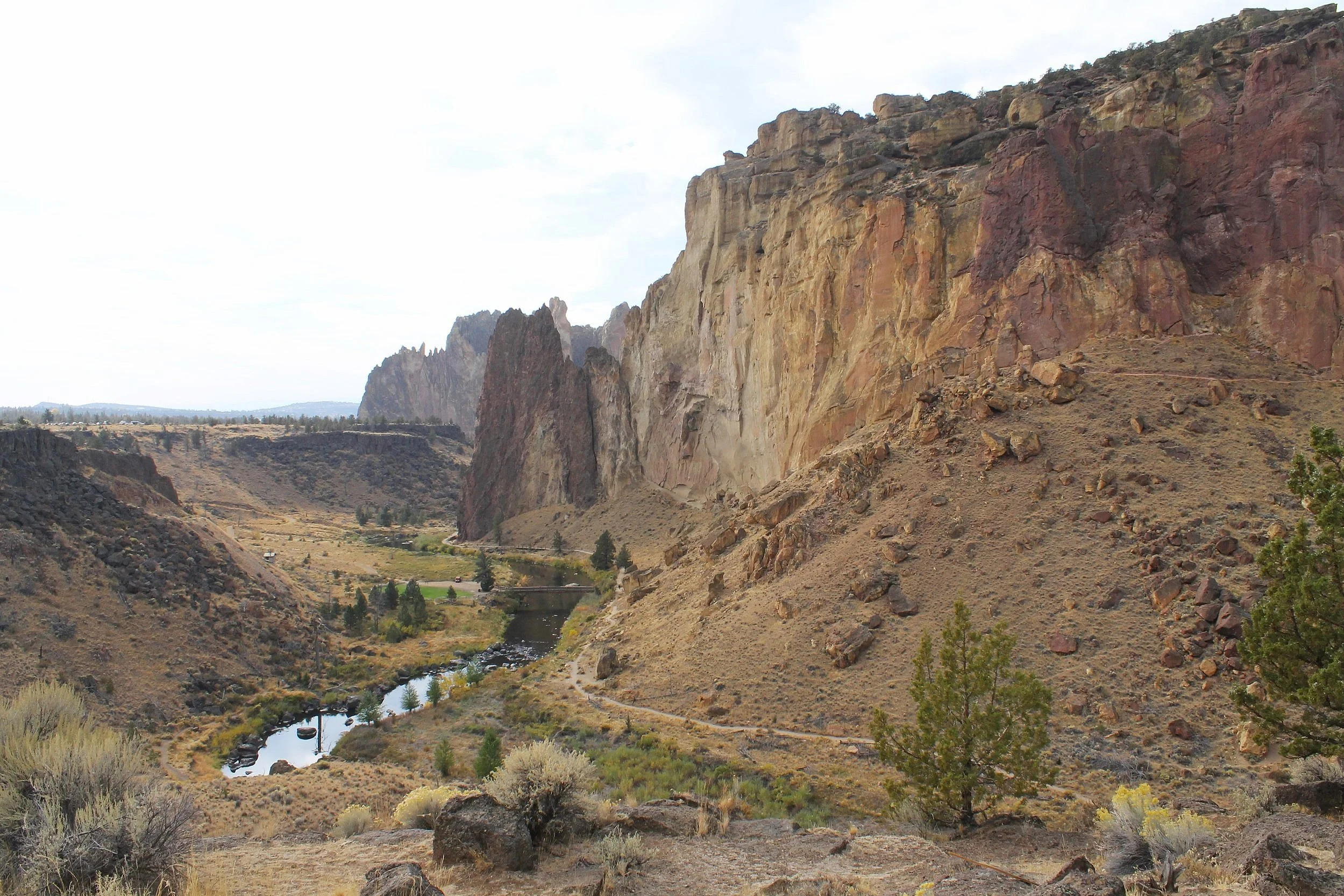
Look for volcanic tuff (right) and basalt (flat ridge to the left)
Smith Rock is one of Oregon’s most unique and incredible geologic stories. The rock formations involve two different volcanic events separated by millions of years. The first was an explosion 29 million years ago that created a massive caldera miles wide that extends as far as Prineville. This explosion also sent out huge amounts of ash and rhyolitic (viscous, silica-rich) lava. Most of the rock on the north side of the Crooked River is tuff, a type of rock made from compressed ash and pumice.
Over millions of years, weathering and erosion contributed to the distinctive appearance of Smith Rock today. The tuff here is fascinating to see up close because of its varied colors and the small embedded rocks contained within it. Look for limestone pieces within the tuff. They’re thought to be part of the original bedrock that was disrupted by the volcanic explosion.
South of the Crooked River is a completely different volcanic story. The basalt plateau there came from far-traveled lava flows from Newberry Volcano during an eruption 400,000 years ago. This lava entered the caldera and changed the course of the Crooked River to its present position.
Getting there
From Portland, take Highway 26 East to Highway 97. Continue on Highway 97 South for 17 miles to reach Terrebonne, then turn left onto Austin Rd. Follow the signs to Smith Rock. You’ll turn left onto Lambert Rd, then left again on Crooked River Dr. The drive takes a little under 3 hours.
From Bend, take 97 North for about 25 miles, then turn right onto Smith Rock Way. Turn left onto Lambert Rd, then take another left on Crooked River Dr. The drive takes about 30 minutes.
Best hikes in Smith Rock State Park, the summary:
Rim Rock Trail
Canyon Trail or the Chute
Misery Ridge Trail
Misery Ridge Loop
River Trail
Wolf Tree Trail
North Point Trail
Enjoy your trip to Smith Rock State Park!
With love,
Emma
Explore nearby

Find the best things to do in Bend, Oregon.

Check out the best short hikes near Bend.

Visit Oregon’s Painted Hills.

Visit the ghost town of Shaniko, Oregon.
Reference:
Miller, Marli Bryant. Roadside Geology of Oregon. Missoula, Montana: Mountain Press Publishing Company, 2014.