

Quick Guide to Sabino Canyon Recreation Area
Sabino Canyon is astounding. Tens of millions of years have transformed this once volcanic landscape into a wonderland of giant cacti, ancient metamorphosed rock, dramatic vistas, and wildlife galore. It has the grandeur of a national park within Tucson city limits. Nationally, it flies under the radar. Locally, it’s well-known and much loved, a rare place to find water in the desert. I’ve been a few times and still have unfinished business. You can sit back and see the canyon on a shuttle tour or try out one of the many hiking trails. Here is everything you need to know about visiting Sabino Canyon in the Coronado National Forest.

Sabino Creek flows through the canyon most of the year
Know before you go
Parking at Sabino Canyon costs $8/day or $10/week. Display proof of payment on your dashboard. The park also accepts the America the Beautiful Pass. If the main parking lot is full, you can use the overflow lot.
Restrooms, drinking water, and picnic tables are at the Visitor Center by the park entrance and some shuttle stops.
The Visitor Center is open 8 AM to 4:30 PM. Inside is a little gift shop and exhibits about the park’s ecology.
You can visit Sabino Canyon 24 hours a day, but overnight camping isn’t allowed.
Dogs are not allowed at Sabino Canyon Recreation Area.
The roads and trails in Sabino Canyon have very little shade. Wear sunscreen, bring lots of water, and try to avoid hiking during the hottest times of the day during the summer.

Sabino Dam
When to visit Sabino Canyon
Sabino Canyon is beautiful all year but gets hot in the summer when daytime temperatures often climb above 100 degrees F. If you visit on a hot day, I’d suggest arriving early to finish up your visit before things heat up too much, say by 10 AM. October through April have milder temperatures that make hiking more pleasant. Visit in the spring to see blooming wildflowers like lupines and golden poppies. Snowmelt from Mount Lemmon and occasional rains keep Sabino Creek flowing most of the time, as do the monsoons from July to September. When Sabino Creek is high, it sometimes floods the paved road through the park. I turned around once because the water on the road reached mid-calf level. High water can disrupt the shuttle service through Sabino Canyon.

Sabino Canyon Road can flood when the creek is high
Navigating the park
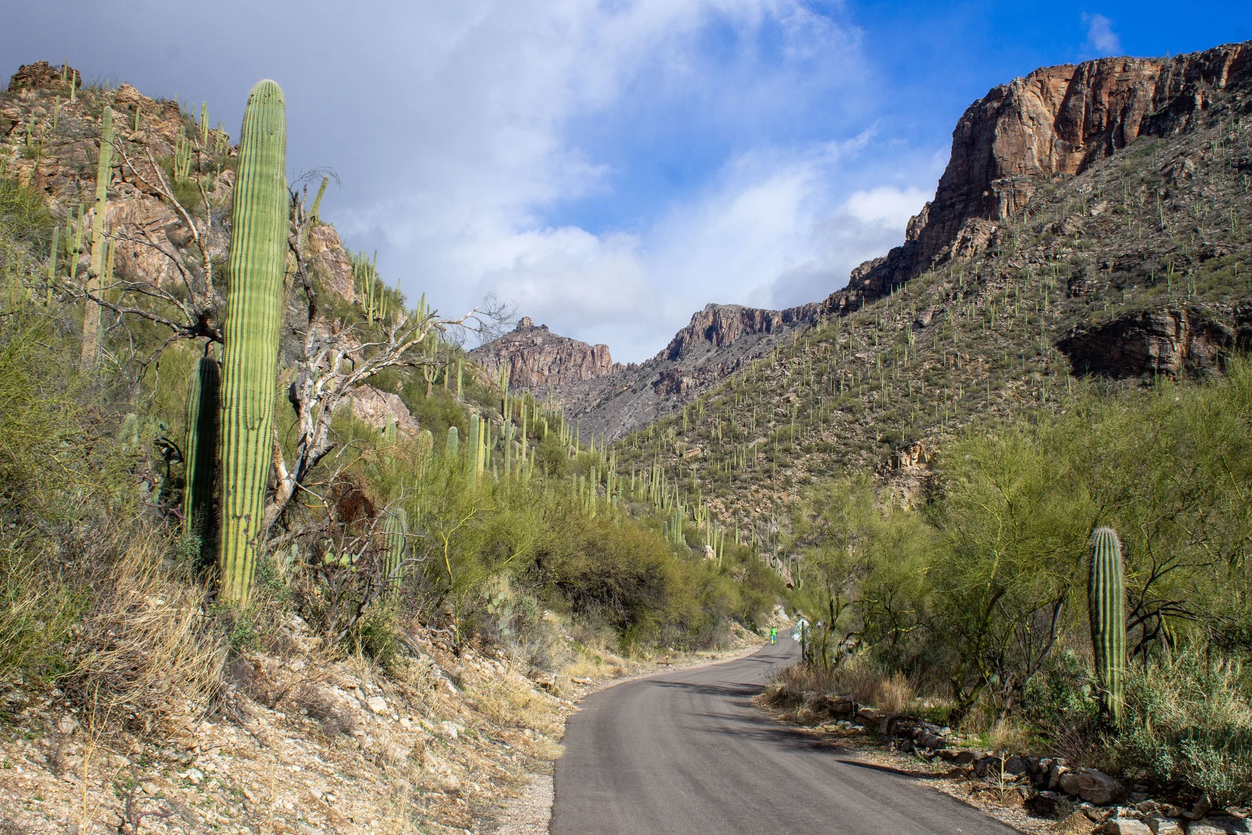
When you enter the park, you’ll be at the Visitor Center. Sabino Canyon Road starts here, a 3.8-mile paved road through the canyon that’s closed to private vehicles. You can walk along it to explore the park and connect to unpaved hiking trails. For an extra fee, a shuttle ride will take you to the end of the road and back. More on that to come. Sabino Canyon Road has nine shuttle stops. Most have amenities like drinking water, restrooms, benches, and picnic tables. About a half mile down Sabino Canyon Road, Bear Canyon Road branches off to the right. This paved road has a separate shuttle and ends at the Bear Canyon Overlook.

Sabino Canyon Road starts from the Visitor Center
If you stick to Sabino Canyon Road, navigation is simple. I’d download a park map or pick up a paper map from the Visitor Center if you explore the unpaved hiking trails. They’re labeled, but the directions aren’t always the clearest.

The Phoneline Trail brings you to elevated viewpoints in Sabino Canyon
Hiking in Sabino Canyon
Now for my favorite part. Sabino Canyon has some of the best hiking trails around Tucson. The options range from short and easy to long and intense. The park has more trails than you could tackle in a single visit or even several. Here are some rewarding hikes that will take you to different areas of Sabino Canyon.
Sabino Canyon Road

Distance: 7.8 miles out and back
Elevation gain: 1,000 feet
Difficulty: Easy
The most obvious hiking option is the paved road through Sabino Canyon. Don’t discount it for being the default choice. This route will take you to some of the park’s most dramatic scenery while avoiding difficult terrain. Curves in the road bring you to new vistas as you move through the canyon. The road is a straight shot, making it almost impossible to get turned around, even for someone as chronically lost as me. There are restrooms, picnic tables, and water spigots along the way. It’s flat and even enough to push a stroller or a wheelchair for most of the journey. Toward the end, there’s a hill with an 18% grade. Look for gneiss cliffs topped with saguaros, views of Sabino Creek, and the distinctive summit of Thimble Peak as you go.
Bajada Loop

The Bajada Loop is a great place to see saguaros and other desert plants
Distance: 0.5-mile lollipop loop
Elevation gain: Minimal
Difficulty: Easy
The Bajada Loop near the Sabino Canyon Visitor Center is a quick and easy hike that will give you a feel for the Sonoran Desert without intense terrain. This barrier-free trail winds through a cactus forest of saguaro, cholla, ocotillo, prickly pear, and creosote. Watch for birds flitting among the plants. Looking north, the Santa Catalina Mountains loom in the background. From the Visitor Center, take the Bear Creek Trail for about 0.1 miles to reach the start of the 0.3-mile Bajada Loop.
Sabino Dam Loop

Sabino Dam
Distance: 2.3-mile loop
Elevation gain: 150 feet
Difficulty: Easy
One of the highlights of Sabino Canyon is seeing water flowing over Sabino Dam when the creek is high. Surrounded by arid desert scenery, this waterway looks surreal as it cascades around giant boulders of chunky gneiss. On hot days, it’s a lovely, if crowded, place to cool off. When I visited on a chilly winter day, it was just me and the roadrunners. To reach the dam, take Sabino Canyon Road until you reach Bluff Trail in about 0.75 miles. Take a right onto Bluff Trail. You’ll get a chance to admire the beautiful and mysterious Sabino Canyon gneiss up close, as well as Sabino Creek. After 0.2 miles, keep right onto the Sabino Dam Trail. The dam will be just ahead. There are picnic tables if you want to linger by the water. When you’re ready to head back, continue on the Sabino Dam Trail until Bear Canyon Trail, then make a right. You’ll be back at the Visitor Center in about a half mile. The Bajada Loop is on the way back for a quick and easy add-on.
Check out the route on All Trails. This hike is a good one to do with a map since there are a few trail junctions along the way.
Rattlesnake Trail and Sabino Lake Loop

Rattlesnake Trail
Distance: 3.7-mile loop
Elevation gain: 250 feet
Difficulty: Moderate
This hike is a slightly longer and harder version of the Sabino Dam Loop. It adds a portion of the Esperero Trail and the Rattlesnake Trail to explore some of the west side of Sabino Canyon. The Rattlesnake Trail follows a wash with good potential for spotting wildlife. From the Visitor Center, walk along Sabino Canyon Road for 0.6 miles, then take the Esperero Trail to the left. After 0.5 miles, take a right onto the Rattlesnake Trail and follow it back to the paved road, 0.4 miles. From here, take the Creek Trail across the road to walk alongside Sabino Creek until you reach the Sabino Dam Trail. You’ll pass the dam, then reach the Bear Canyon Trail. Take a right to follow the Bear Canyon Trail back to the Visitor Center.
Check out the route on All Trails. Have a digital or physical map with you when you hike.
Blackett’s Ridge

I’m happy to sit down along Blackett’s Ridge Trail
Distance: 6 miles out and back
Elevation gain: 1,700 feet
Difficulty: Hard
The hike up Blackett’s Ridge is one of the most rewarding and strenuous hikes in Sabino Canyon. Although not long, the steep, unshaded trail makes you work for the views. From the Visitor Center, take the Bear Canyon Trail 0.8 miles and then take a left onto Phoneline Trail. You’ll reach the start of Blackett’s Ridge Trail in another 0.6 miles. From here, you’ll have incredible views of Tucson Valley, the Santa Catalina Mountains, and the distant Santa Rita Mountains. It’s a long, hot uphill slog to the end of the trail, but it isn’t technical. Bring tons of water. Wear sunscreen and a hat. The views are great throughout, so don’t be reluctant to turn around early if it starts getting too hot. Several false summits along the way will have you feeling like you’re at the top of the world. The trail ends with a sign saying you’ve finished.

The views from Blackett’s Ridge Trail are awesome
The easiest way to tackle Blackett’s Ridge is an out-and-back hike. To add variety, you can start on Sabino Canyon Road and take a right onto the Phoneline Link Trail at shuttle stop #1. Continue up switchbacks for 0.9 miles and then take a right onto the Phoneline Trail. In 0.4 miles, you’ll be at the start of the Blackett’s Ridge Trail. On the way back, head down the Phoneline Trail to the Bear Canyon Trail to make it a loop. This version adds little distance and elevation gain but will give you more views of Sabino Canyon on the way up.
Seven Falls via Bear Canyon

Bear Canyon Trail
Distance: 8.4 miles out and back (5.8 miles with shuttle ride)
Elevation gain: 1,000 feet
Difficulty: Moderate
The hike to Seven Falls is the most famous in Sabino Canyon. It’s best when water is flowing over the multi-tiered waterfall. On hot days, the pool beneath the falls is a tempting place for wading. The trail to the waterfall isn’t strenuous, but it’s on the longer side and has no shade. Bring lots of water and avoid hiking during the hottest times of the day. You can walk from the Visitor Center for an 8.4-mile out-and-back hike or take the Bear Canyon Shutte ($8) to stop #3 at Bear Canyon Overlook. The shuttle ride brings the hiking distance to under 6 miles roundtrip. After hiking or riding to the Bear Canyon Overlook, continue 2.9 miles on the Bear Canyon Trail to Seven Falls. The trail to the waterfall is surrounded by towering saguaros with views of the Santa Catalina Mountains to the north. Expect some stream crossings along the way if it’s not too dry.
Sabino Canyon Trail

The Sabino Canyon Trail starts at the end of Sabino Canyon Road
Distance: 5 miles out and back (after shuttle ride)
Elevation gain: 200 feet
Difficulty: Moderate
I haven’t done this hike yet, but I want to because it maximizes how much of Sabino Canyon you can see without a super long hiking distance. Take the Sabino Canyon Shuttle ($15) to the last stop, #9. From here, you can begin the Sabino Canyon Trail for a 5-mile out-and-back hike that starts where the road ends. The trail begins with some steep switchbacks but then levels off as it follows a ridge line. If you’re up for another 3 miles, you can reach Hutchs Pool, a water feature on the West Fork Trail. After finishing the trail, hike or take the shuttle back down Sabino Canyon Road.

Shuttle stop #9
Biking
You can bike on Sabino Canyon Road before 9 AM or after 5 PM on days other than Wednesdays and Saturdays. Since sunsets are often around 6 or 7 PM, the morning hours will give you a little more daylight than the evening. Sabino Canyon Road is wide and smooth, making it a great biking route. It’s about 8 miles to reach the end of the canyon and back. The route has some hills but never gets very intense. Share the road with pedestrians. There’s plenty of room to pass comfortably. E-bikes aren’t allowed in the park. Biking is only allowed on the paved road, not on other trails.
Sabino Canyon Shuttle Tours

The shuttle is an easy way to see Sabino Canyon
You don’t need to hike to enjoy Sabino Canyon. Two shuttle options will transport you in comfort to some of the park’s most impressive scenery. The Sabino Canyon Crawler is an all-electric, open-air shuttle that runs to the end of Sabino Canyon Road, about an 8-mile roundtrip. The Bear Canyon Shuttle is a gas-powered, enclosed van that brings you to the Bear Canyon Overlook, a little under 4 miles roundtrip. You can buy tickets for the shuttle tours with a credit card at the outdoor pay station or pay the shuttle driver with exact change. Tours depart hourly. They sometimes sell out during popular times. You can buy tickets online ahead of time to know you’ll have a spot when you get there.
Sabino Canyon Shuttle:
$15 for adults
$8 for kids 3-12
$8 for the return trip only
Free for kids under 3
If it’s your first time visiting Sabino Canyon, the open-air tour is a perfect introduction. You’ll get recyclable earbuds to plug in and listen to a tour of the canyon’s history and ecology as you ride. The shuttle passes nine stops. You can get off at any of them and walk, or continue until the end (stop #9) and ride back. If the shuttle has seats available, you can catch it on the way back from any of the stops. Shuttles accommodate up to two wheelchairs on board. A fun way to explore Sabino Canyon is to go for a hike and then come back to the Visitor Center to take the shuttle tour. Sitting down feels amazing after hiking in the heat.

Sabino Canyon Crawler
Bear Canyon Shuttle:
$8 for adults
$5 for kids 3-12
$5 for return trip only
Free for kids under 3
The Bear Canyon Shuttle starts down Sabino Canyon Road, then branches off, ending at the Bear Canyon Overlook. The shuttle is enclosed and air-conditioned. It will keep you cooler on a hot day, but you miss out on a lot of the scenery by being in a van. This shuttle doesn’t have an audio tour. Taking the Bear Canyon Shuttle would be a good way to shorten the distance to Seven Falls. The shuttle can accommodate up to two wheelchairs.
Plants, animals, and rocks of Sabino Canyon

Sabino Creek flows around banded gneiss
Ancient rock forms Sabino Canyon. Volcanic activity deposited granite here around 50 million years ago. The movement of tectonic plates over tens of millions of years stretched the granite and sliced it into sheets. The result is the beautiful banded rocks in the canyon today, called gneiss (pronounced “nice”). As the Sabino Canyon audio tour will tell you, much remains mysterious about how the gneiss formed. The geologic stretching of this area created many faults in the rock, producing cracks and some impressive cliff faces.

Sabino Creek carved out the canyon, producing steep slopes
Around 12 million years ago, the land around the Santa Catalina Mountains began sinking, creating what is now the mountain range, essentially the land that didn’t sink. Since the mountains formed, Sabino Creek has eroded the canyon, producing its steep walls and dramatic contours.

Santa Catalina Mountains
The water that flows through Sabino Creek makes the canyon’s environment unlike that of most deserts. You’ll see plenty of typical Sonoran Desert trees like Mesquite and Palo Verde, but also some surprises. Trees like cottonwoods, ash, and alders grow along the banks of Sabino Creek. A variety of cactus species thrive in Sabino Canyon, including towering saguaros and teeny tiny pincushion cacti. The hiking trails are a cactus extravaganza of cholla, prickly pear, and ocotillo.

Deciduous trees grow in the Sabino Creek bed. Thimble Peak is in the background.
Animals in Sabino Canyon tend to be shy and well-camouflaged, making them hard to spot. Your best chances of seeing them are along the unpaved hiking trails, especially on quiet days in the early morning or later afternoon. Many birds live in the park, like roadrunners, cactus wrens, Gambel’s quails, kestrels, Cooper’s hawks, sparrows, and cardinals. I learned a new bird when I visited: the Phainopepla. It looks like a black cardinal but is more closely related to a cedar waxwing (also in Sabino Canyon).

Roadrunner
Other animals you might see are deer, foxes, coyotes, bobcats, and reptiles like rattlesnakes and Gila monsters. The park service estimates that four mountain lions live in Sabino Canyon. Sightings are rare but possible.
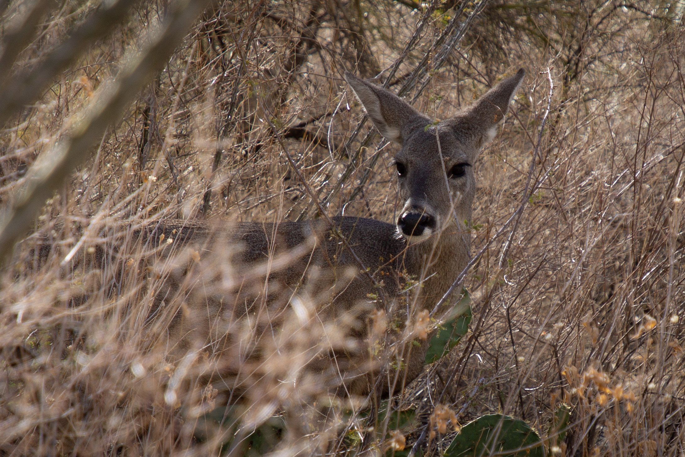
Deer beside the Phoneline Link Trail
The animals I saw most on the trail were the cute little lizards scurrying around the rocks.

One of many lil’ lizards
Enjoy your trip to Sabino Canyon!
With love,
Emma
Getting there
Address: 5700 N Sabino Canyon Road, Tucson, AZ 85750
Sabino Canyon Recreation Area is in the northeast corner of Tucson. The drive from downtown takes about 45 minutes. Public transit does not connect to the park.
Explore nearby


Find tips to help plan your trip to Tucson in the winter.