

How to Enter Devils Punchbowl on the Oregon Coast
After years of visiting the Devils Punchbowl and longing to go inside, I planned a trip to the Oregon Coast around the tide. When seen from above, the Devils Punchbowl is more impressive at high tide when waves enter and churn inside it. The catch is that they also make it impossible to approach. There is something irresistible about going somewhere hidden and ephemeral, a place where nature usually forbids entry. For kindred spirits out there, here is how to get inside the Devils Punchbowl, safely.

Devils Punchbowl at low tide
Quick directions
From the parking lot at the end of 1st Street, walk east toward C Ave.
Take the walking trail on C Ave north.
After you pass 3rd Street, look for the beach access trail to the left.
Follow the access trail 0.1 miles to the beach. Turn left to head south on Otter Crest Beach.
When you reach the cliffs, look for a couple of arches connecting the beach to Devils Punchbowl.

Map courtesy of Google Maps. Route annotation is mine.
Know before you go
Parking: Devils Punchbowl State Natural Area has two public parking lots. The one at the end of 1st Street is closer to the viewpoint overlooking Devils Punchbowl from above (next to Mo’s Restaurant). The other lot on C Ave is closer to the beach trail. Park whenever you find a spot. The lots are only a couple of blocks apart.
Cost: Parking at Devils Punchbowl requires the Oregon State Park Pass, $10/day or $60/year. Stay in the public parking areas to avoid parking on private property.
Restrooms are between the two parking lots at the corner of 1st Street and C Ave.
Look for a large picnic area at the end of 1st Street. The tables overlook the ocean.
Dogs are welcome at Devils Punchbowl State Natural Area. It’s difficult to enter the Punchbowl with a dog because of the slippery rocks. Other areas in the park are dog-friendly, like the trail and viewpoint above Devils Punchbowl, Otter Crest Beach, and Beverly Beach.
Hiking and accessibility: To get inside the Devils Punchbowl, you’ll need to walk about a mile round-trip. The terrain includes irregular surfaces and slippery rocks.

Check out Devils Punchbowl from above before heading to the beach
Tides and safety tips
I don’t usually plan a trip to the Oregon Coast entirely around the tide. Entering Devils Punchbowl is an exception. Here is how to do it:
Use a tide chart to plan your visit. Not all low tides are the same. Visit when the tide is at or below zero. It was around -1 when I went, giving me plenty of time to explore.
Arrive about 30 minutes to an hour before low tide so that the tide is falling when you’re there.
You’ll have more opportunities to enter Devils Punchbowl during summer because the lowest tides happen during daylight hours.
Visit on a calm day. Don’t hike down into Devils Punchbowl during a storm or if the waves are high.

High tide fills Devils Punchbowl
Besides keeping an eye on the tide, you’ll need to watch your footing. The rocks around and inside the Devils Punchbowl are slippery. I’m calling this hike moderate for that reason alone. Wear shoes with traction and take your time.
Many of the other hikers when I visited were families with children. The older kids were doing just fine, but I can’t recommend it for younger kids. The rocks are slick and the waves are close. I watched a toddler slide down a rock toward the ocean while I was inside. He was okay, but I about had a heart attack. I’d suggest skipping this one with kids younger than seven.

You’ll enter Devils Punchbowl at the base of these cliffs
How to enter Devils Punchbowl
Distance: 1 mile out and back, including the viewpoint from above
Elevation gain: 100 feet
Difficulty: Easy to reach Otter Crest Beach. Moderate to get inside the Devils Punchbowl due to slippery rocks.
Pass required: None
Dog-friendly: I would skip entering the Devils Punchbowl with a dog because of the terrain. Otter Crest Beach is dog-friendly.
ADA access: No
When to visit: Low tide

Inside Devils Punchbowl
The details:
Starting from the parking area at the end of 1st St, stop by the viewpoint overlooking the Devils Punchbowl from above. It should be empty without waves entering it if you’re going inside.

The tide was about -0.5 here
To get down to the beach, head back the way you entered on 1st St. When you reach C Ave, take a left onto the walking trail. You’ll pass the other public parking lot for the Devils Punchbowl.

Take this path along C Street to get to Otter Crest Beach
Walk for a few blocks and you’ll see the beach access trail to your left. It will be just past 3rd St. Make sure that the trail is open before you continue. It closes when conditions aren’t safe on the beach.

Beach access trail
After 0.1 miles on the paved trail, you’ll reach a drop-off where the trail eroded. It’s about 4 feet high. You can still get to the beach by walking down the dirt slope next to the drop-off. It’s steep but doable.

Otter Crest Beach and Marine Gardens
Once you’re on Otter Crest Beach, you’ll see Gull Rock straight ahead. This large, flat sea stack is a favorite of seabirds. Low tide exposes the wave-cut platforms on Otter Crest Beach. These are worth exploring to see tidepool critters, but I suggest waiting until after you see the Devils Punchbowl to make sure you don’t miss low tide.

Intertidal area on Otter Crest Beach and Gull Rock
Head left on Otter Crest Beach towards Devils Punchbowl. The first part of the journey is an easy walk on the beach.

Head towards these cliffs
As you get closer, you’ll start negotiating the rocks and boulders that have fallen from the surrounding cliffs. Avoiding them is easy at first, but watch your step. They can be slippery.

Walk around and over these rocks
When you reach the cliffs, you’ll pass a couple of small caves. These recesses are intriguing but don’t connect to Devils Punchbowl.

Caves on the way to Devils Punchbowl
They are good places to find shore crabs skittering across the rocks and hiding in crevices.

Lined shore crab
Follow the cliffs out toward the ocean to reach the two entrances to Devils Punchbowl. You’ll see a path where hikers have worn off the seaweed.

Follow this trail
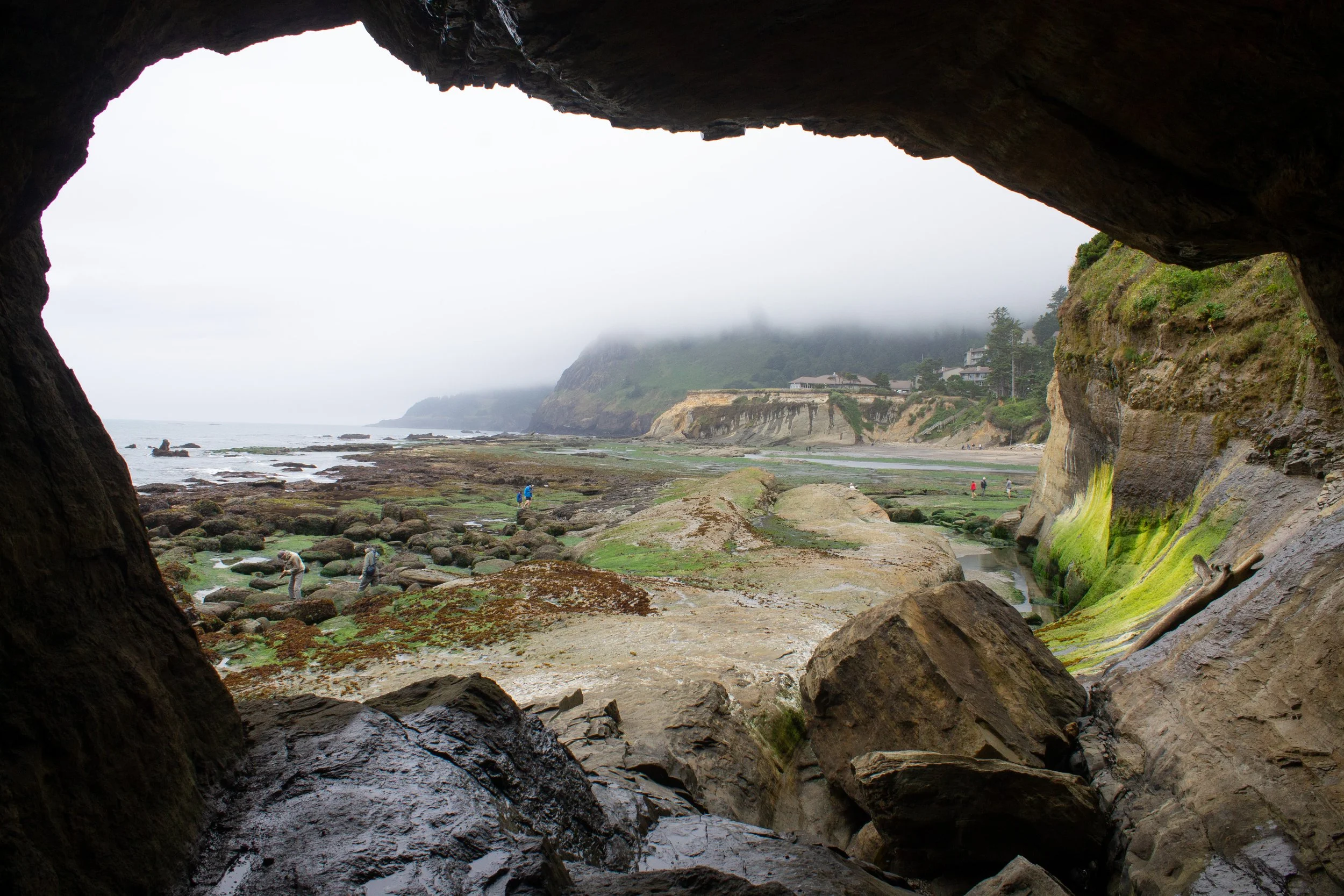
Two arches through the sandstone cliffs connect Otter Crest Beach to the Devils Punchbowl. Go ahead and enter through either one. They are right next to each other.

First entrance to Devils Punchbowl
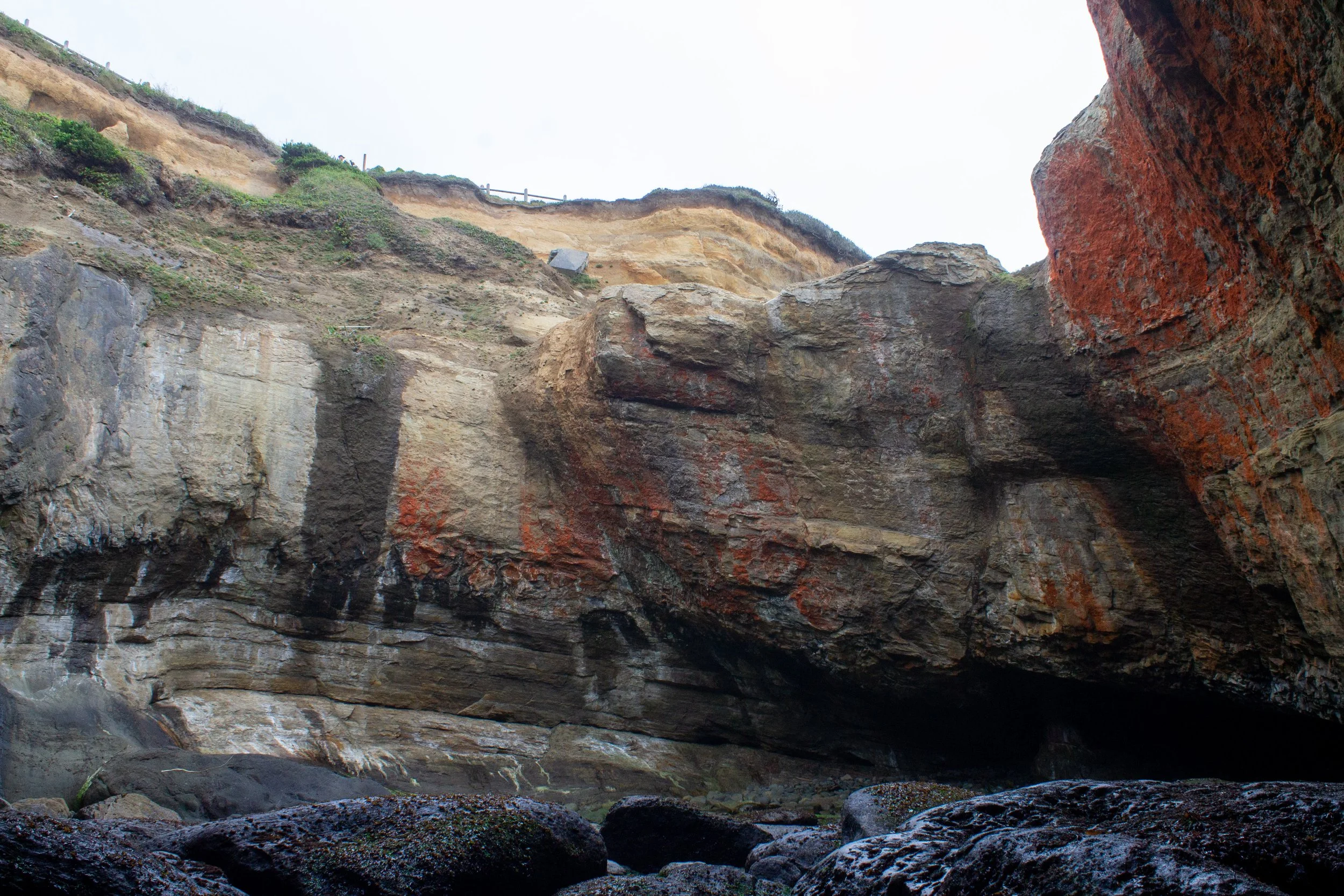
Now for the mind-blowing part. Once you’re inside Devils Punchbowl, a colossal sandstone amphitheater surrounds you. Weathering has created streaks of orange on its otherwise buff-colored surface. Boulders litter the ground, casualties of crashing ocean waves and time.

Inside the Devils Punchbowl
If you totter over the slick rocks, you can explore the Punchbowl’s interior. You’ll see the two arches connecting to the beach, plus a third that opens up to the ocean. Even at the lowest tide, waves lap gently against the rock-strewn floor of the Punchbowl, a reminder to keep an eye on the tide.

Second entrance
The best tidepools are outside of the Devils Punchbowl on Otter Crest Beach, but you can find some intertidal life if you look carefully. Your best bet is around the arch that opens to the ocean. Take care as it is also the most hazardous place to hang out. Look for some anemones and perhaps a sea star or two.

Giant green anemone clings to the inside of the Devils Punchbowl
It’s hard to capture the size of the Devils Punchbowl on camera and the experience is much more powerful in person. On the Punchbowl’s rim, you’ll see the viewpoint that looks down into it from above. The teeny tiny fence helps provide a sense of scale.
Viewpoint from inside Devils Punchbowl
Otter Crest Beach and Marine Reserve
Even without access to Devils Punchbowl, Otter Crest Beach would be worth visiting. The beach occupies a broad cove between Devils Punchbowl and Cape Foulweather, which looms to the north. At low tide, wave-cut platforms make it one of the most unique beaches on the Oregon Coast.

Otter Crest Beach from above
Otter Crest Beach has a fantastic intertidal zone. If you tread carefully on the slick surfaces, you can find anemones, barnacles, sea stars, mussels, sculpins, and crabs.

Giant green anemones, sea stars, and algae in the marine garden
Since it’s easier to see the tide coming in from the beach than it is from inside the Devils Punchbowl, you can spend more time lingering in the marine garden before waves cover the tidepools. Watch for seabirds overhead as you walk on the beach.

Lined shore crab
Getting there
Coming from the north, take Highway 101 S until Otter Crest Loop, then turn right. Just ahead, take a left to stay on Otter Crest Loop. In 0.2 miles, take a right onto 1st St. Look for public parking at the end of 1st St.
The Devils Punchbowl is 10 minutes south of Depoe Bay and 25 minutes south of Lincoln City. The drive from Portland takes about 2.5 hours.
From the south, take Highway 101 N until you see the sign pointing toward Devils Punchbowl. Make a slight left onto Otter Crest Loop. In 0.4 miles, take a left onto 1 St and look for public parking at the end of it. The Devils Punchbowl is about 10 minutes north of Newport.
Enjoy your journey into Devils Punchbowl!
With love,
Emma
Explore nearby

Check out my full guide to Devils Punchbowl State Natural Area.

Check out the best road trip stops from Depoe Bay to Newport.

Best road trip stops from Lincoln City to Depoe Bay.

Find the best things to do in Newport, Oregon.

Visit the best Oregon Coast beaches for tide pools.