

Hike the Hood River Pipeline Trail


I nominate the Hood River Pipeline Trail for Oregon’s weirdest hike. It begins at a crumbling, graffiti-covered decommissioned power station. From here, it follows working railroad tracks where, yes, you do need to watch for trains. Then, after a brief stroll on a normal hiking trail, you’ll finish the trek on a metal catwalk above an enormous empty pipeline. Alongside the trail’s industrial features are wildflowers, berry bushes, a lush forest, and the scenic Hood River. It’s a journey that will make you both whistle in admiration and scratch your head in bafflement before you’re done. Here is everything you need to know about hiking the Hood River Pipeline Trail.

The hike begins on railroad tracks
Know before you go
Parking for the Hood River Pipeline Trail is free. You don’t need a pass or permit to park.
The hike starts on active railroad tracks. Listen for trains and be prepared to move off the tracks if you hear one approaching.
Dogs are allowed on the trail, but the surfaces aren’t dog-friendly. The metal walkways are too sharp for paws.
The metal catwalk on the Hood River Pipeline Trail is fenced and family-friendly.
There’s a picnic table or two near the parking lot but no restrooms.
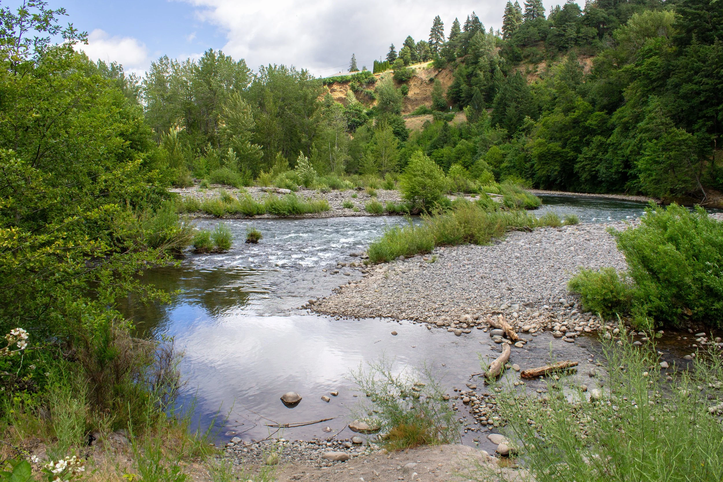
The hike follows the Hood River
On the Hood River Pipeline Trail
Distance: 3 miles out and back
Elevation gain: 100 feet
Difficulty: Easy
Passes required: None
Dog friendly: Dogs are allowed, but please don’t bring your dog on this hike because of the sharp metal grating on the pipeline.
ADA access: No
Season: All year

Powerdale Powerstation
The details:
You’ll park next to the decommissioned Powerdale Powerhouse, which supplied electricity to the town of Hood River before a 2006 flood destroyed the dam upstream. Today, the power station is mostly a canvas for graffiti, giving it a decidedly post-apocalyptic look. The broken windows and blackberry brambles only add to this impression. Like all abandoned buildings, it’s irresistible to peek inside. Proceed with caution. Trash and broken glass cover the floor.

Inside the power station
After seeing the power station, head to the railroad tracks. A railroad trestle crosses the Hood River. Walk away from it to start the hike toward the pipeline.

Head away from the trestle to begin the hike
You won’t be on the tracks long, less than a half mile. On the way, you’ll pass a sealed-off segment of the pipeline that once supplied the power station with water from the river. During my early summer hike, bachelor buttons and buckwheat were blooming next to the railroad tracks.

Bachelor buttons bloom along the railroad tracks in June
After about a quarter mile, start looking for the dirt trail between the railroad tracks and the Hood River. It will be on your right. You’ll want to leave the tracks as soon as you can since trains can and do run here. If you miss the start of the dirt trail, it’s an awkward rocky scramble to get off the tracks when a train comes. Ask me how I know.

Take the dirt trail to avoid trains
The next leg of the journey is the only one that resembles a traditional hiking trail. The dirt path follows the Hood River. You’ll have a few opportunities to get down to the water, including a couple with narrow sandy beaches. Snowmelt from Mt Hood feeds the river, so expect it to be cold even in summer. Look for birds swooping down close to the water on the hunt for bugs.

The trail follows the Hood River
Late-blooming wildflowers like bachelor buttons, vetch, and yarrow linger in the tall grasses along the trail. If you hike while the mock orange bushes are blooming, it’s worth stopping for a moment to appreciate the fragrance. Later in the summer, look for blackberries ripening.

Bachelor buttons bloom next to the Hood River
Before long, you’ll reach the hike’s main event, the penstock pipeline. Before the 2006 flood damage, this pipe carried water from the Powerdale Dam to the power station. The dam was removed in 2010 and the Hood River now flows unrestricted. Much of the pipeline is gone as well. What remains is empty and exists only for the novelty of walking on it. A metal catwalk runs along the top of the pipeline, making the journey safe and easy.
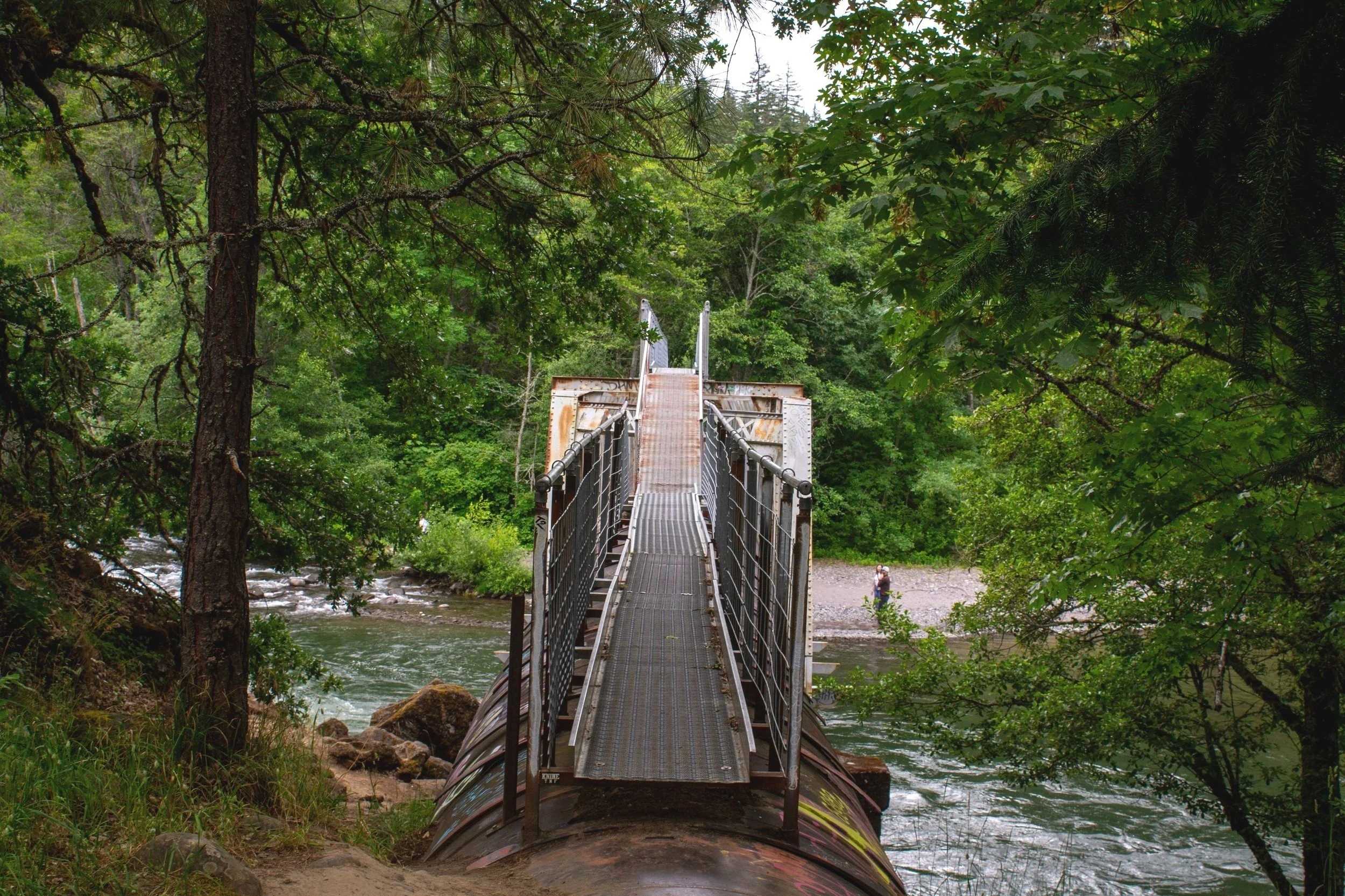
Start of the metal catwalk
In place of a conventional bridge, you’ll cross the Hood River on the catwalk. Hike at an uncrowded time if you can. Passing others is a bit of a squeeze.

Crossing the Hood River
Once across, you’ll see a ladder to the right of the catwalk. You can use it to get down to the Hood River and a stretch of sandy beach if you want. Otherwise, continue on.

Use the ladder on the right to descend to the beach
The pipeline continues for another 0.6 miles through a forest of big leaf maples, alders, Doug firs, and even a few ponderosas. The rest of the journey is flat and easy using the catwalk. The pipeline is impressive throughout with its nearly 10-foot diameter. You’ll be high above the blackberry bushes as you walk. At times the pipeline’s sides are metal, other times wood. The hike ends when you reach the end of the pipeline. Some old support posts remain next to the river, a legacy of the pipeline’s original longer course that extended to the Powerdale Dam. When you’re ready, head back the way you came to return to the parking lot.

End of the catwalk, and the hike
Getting there
Look for the Hood River Penstock Flume Pipeline Trailhead on Google Maps.
From Portland, take I-84 E to Exit 64 in Hood River. At the end of the exit ramp, take a right onto the Mt Hood Hwy. In a quarter mile at the stop sign, continue onto OR-35 S. In another quarter mile, take a right onto Powerdale Rd. The parking area will be at the end of the road. The drive from Portland takes about an hour.
Enjoy your hike on the Hood River Pipeline Trail!
With love,
Emma
Explore nearby

Visit the Hood River Fruit Loop.
Hike or bike through the Mosier Twin Tunnels.

Try out the best short hikes in the Columbia Gorge.