

Hike to Goat Marsh Lake


Just south of Mount St Helens, the trail through Goat Marsh Research Natural Area is one of the least visited and most beautiful hikes in southern Washington. Remarkable for its diverse ecology, this short trail passes through old-growth forests, grasslands, and wetlands before ending at a lake that volcanic eruptions created. Today, the lake is a peaceful escape where ducks, frogs, salamanders, and beavers make their home. Best of all, the snowy summit of Mount St Helens reflects off the lake on a clear day, creating a perfect mirror image. Here is everything you need to know about the hike to Goat Marsh Lake.

Goat Marsh
Know before you go
Parking is free at the Goat Marsh Trailhead. You don’t need a pass or permit. Look for a few spots off the side of the road near the trailhead.
The roads to the trailhead are paved and in good condition until the last half mile or so. The end of the drive is bumpy but doable in a low-clearance vehicle.
Leashed dogs are welcome on the trail.
Goat Marsh Lake is a protected research area where camping, vehicles, and stock are prohibited. Leave your cows at home.
There are no restrooms or amenities at the trailhead. Look for close-ish restrooms at the Lake Merrill Day Use Area.
Hike on a clear day if you can. Although pretty in any weather, the views of Mount St Helens are the trip highlight.
The trailhead may be inaccessible due to snow in winter and spring.
Consider bringing bug spray in the summer to avoid the biting flies.

Rough-skinned newt in Goat Marsh Lake
On the trail to Goat Marsh Lake
Distance: 2.4 miles out and back
Elevation gain: 200 feet
Difficulty: Easy
Pass required: None
Dog friendly: Yes, leashed dogs are welcome on the trails.
ADA access: No
Season: Best in summer and fall

Mushrooms grow on a fallen log near the trail
Basic directions:
Navigation for this one is easy. From the Goat Marsh Trailhead, stay on the trail until you reach Goat Marsh Lake. You’ll pass the junction with the Kalama Ski Trail, which you can ignore. The trail peters out at the end but will reach excellent lake views.

Goat Marsh Trailhead
The details:
The Goat Marsh Trailhead is a nondescript, unlabeled trail beginning at NF-8123. Parking is equally unmarked, but you’ll see where the road widens enough to fit a couple of cars. Look for a wide dirt path with a sign that says No Motor Vehicles. This is the trail to Goat Marsh Lake.

Mushrooms are varied and wonderful along the trail
The hike begins as an easy stroll through a forest. An early snowfall in the Cascades left lingering snowy patches on the trail when I visited at the end of October, a reminder that although flat, this hike is at 3,000 feet of elevation and on the slopes of a volcano. Although past eruptions have shaped the landscape, you can find plenty of life here today. A carpet of bright green moss grows on the volcanic soil. Lodgepole pines shade the trail. In the fall, you can spot some mushrooms the size of dinner plates as you walk.

Streambed crossing
After about 0.2 miles, you’ll see a smaller unpaved trail branching off to the left. You can continue on the wider trail to cross a dry streambed. This crossing is a bit ambiguous, but you’ll see signs of where people have gone before. Alternatively, you can take the smaller trail off to the left to reach a slightly better crossing and then take a right to rejoin the Goat Marsh Trail. In either case, you just want to make it across the streambed. On the other side, you’ll see a sign reassuring you that you haven’t lost the trail.

Look for this sign on the other side of the streambed
Soon after crossing the streambed, you’ll reach a split rail fence that marks the boundary for the Goat Marsh Research Natural Area. From here, the trail continues through the forest for about 0.5 miles before you reach Goat Marsh.

Entering the Goat Marsh Research Natural Area
For me, Goat Marsh is where the hike becomes great. Tree cover along the trail thins to reveal a shallow marshland and grassy meadow beyond where elk sometimes graze.

Goat Marsh Lake
As you circle this clearing, you’ll begin to see the blunted, 8,300-foot peak of Mount St Helens towering above the trees in the distance. The views improve as you walk, and soon the entire mountain is visible from the trail.

Look for Mount St Helens across the marsh
From here, the trail rounds a corner and returns to the forest, where I saw a baby garter snake slithering across the path. In early summer, look for wildflowers like trillium, avalanche lilies, and vanilla leaf. Bunchberries are especially abundant along the trail. In the fall, look for an impressive variety of mushrooms and colorful changing leaves in the undergrowth.

A last glimpse of the mountain before returning to the forest
After a short walk through the forest, you’ll reach Goat Marsh Lake. Volcanic activity from Mount St Helens formed this lake several hundred years ago when pyroclastic flows created a natural dam across Coldspring Creek. When Mount St Helens erupted in 1980, pyroclastic flows devasted the north side of the mountain but didn’t reach the southern slopes. Although landslides and volcanic debris still impacted the south side, forests survived here. You’ll see huge trees near Goat Marsh Lake, including old-growth Doug firs and some of the largest noble firs in the world.

Snow can make the trail challenging in places
When you reach the lake, the trail becomes a little tricky, especially when snow on the path has started to turn icy. It would be no problem in summer with hiking boots or even sneakers, but in late fall, I would have liked more traction as I teetered at a snail’s pace on the narrow trail next to the icy-covered lake. After this narrow stretch, the trail improves again as it follows the lakeshore. Look for large logs in the lake that are casualties of beaver activity. Across the water, you’ll see the dacite cliffs of Goat Mountain.
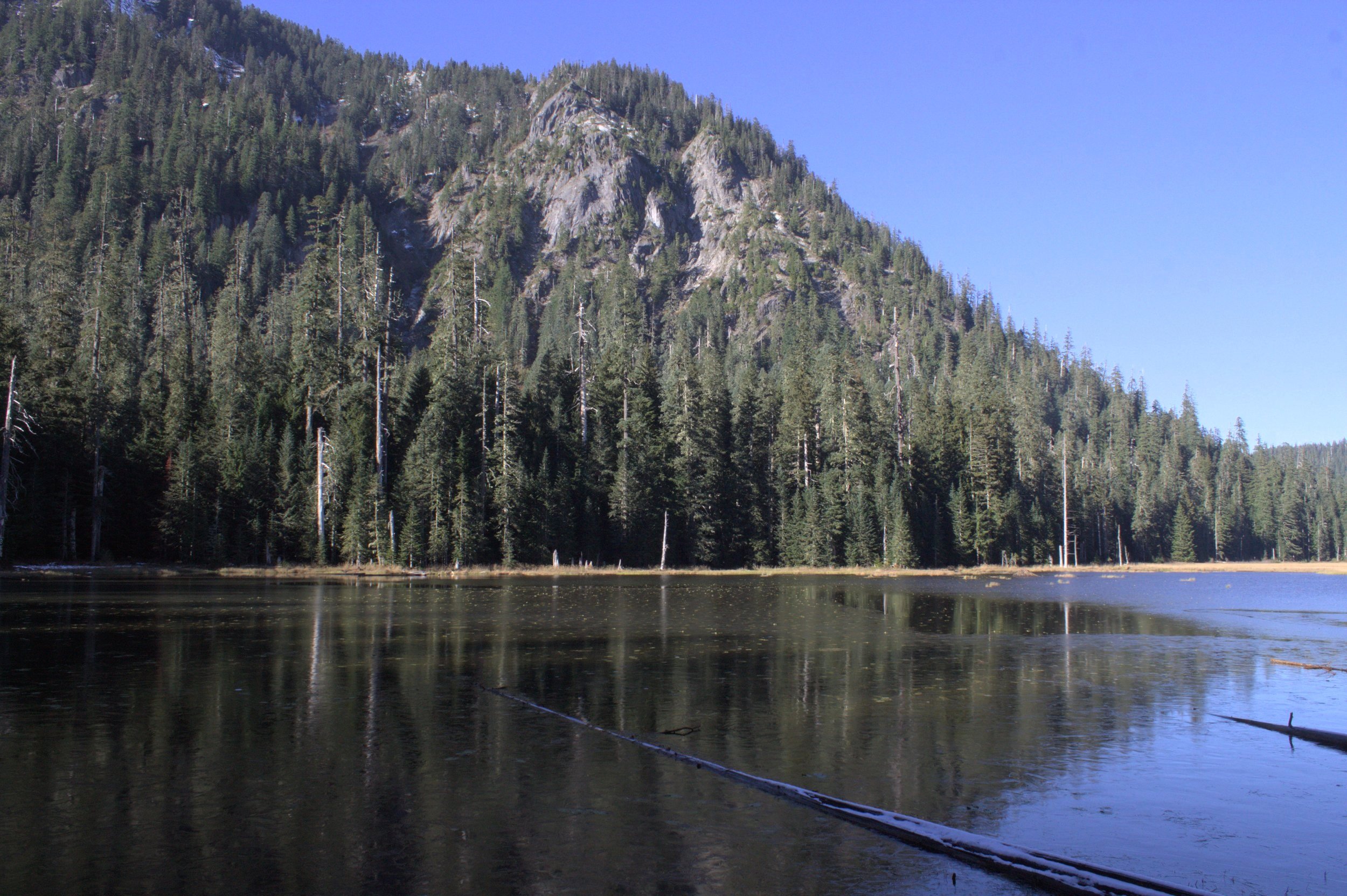
Goat Mountain
As you begin circling the lakeshore, Mount St Helens comes back into view. Soon after, the trail starts to fade. There is also a lot of, shall we say, evidence that this area is a favorite for elk.

Mountain views return
It’s hard to pinpoint exactly where the trail ends, but it’s worth persevering for about 0.2 miles along the lakeshore to reach an angle where the summit of Mount St Helens reflects off the lake like a mirror image.

Goat Marsh Lake
Despite its murky bottom, the waters of Goat Marsh Lake are clear, making it easy to spot rough-skinned newts swimming near the shore.

Rough-skinned newt
In summer, look for dragonflies flitting around the wetland grasses and frogs sunning themselves on fallen logs. Out on the lake, look for ducks, geese, and beavers. Looking toward the mountain, you’ll see a large beaver dam.
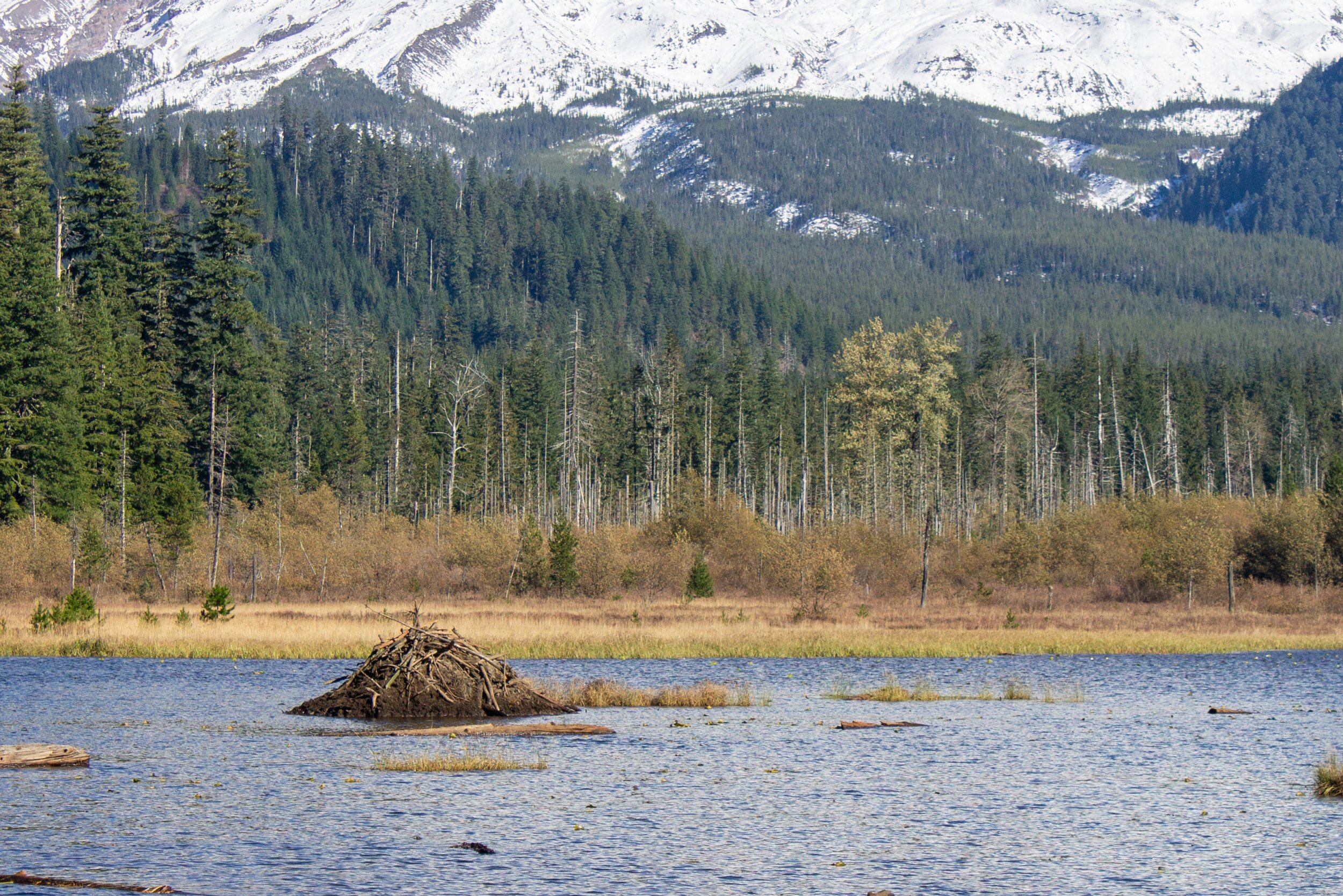
Beaver dam
When you’ve finished admiring the lake, head back the way you came to return to the car.

Goat Marsh Lake
Bonus hike options
Since hiking at Goat Marsh Lake means a long drive to a short trail, you might want to explore the area after you’re done. On the way from Portland to the trailhead, you’ll pass the Lake Merrill Day Use Area. An easy, 1-mile interpretative loop trail begins here and takes you through the forest along the lakeshore. Make sure to have a Washington Discover Pass if you stop here.

Merrill Lake
A short detour from the Goat Marsh Trailhead (about a 20-minute drive) will bring you to the Trail of Two Forests Interpretative Site. Here, a 0.25-mile boardwalk trail explores an area covered by pyroclastic flows from Mount St Helens 2,000 years ago. Along the way, you’ll see the casts of trees destroyed by the eruption. Use the NW Forest Pass or America the Beautiful Pass to visit from April 1st to Nov 30th (or the Washington Sno-Park pass from Dec 1st to March 30th).

Tree mold created by lava flows
Less than a mile from the Trail of Two Forests, the Ape Cave is open from May 18th - Oct 31st. Here you can explore a giant lava tube beneath the earth. You’ll need to plan ahead a little to tackle this one by getting a timed reservation. You’ll also need a NW Forest Pass or America the Beautiful Pass to park.
Getting there
To reach the Goat Marsh Trailhead from Portland, take I-5 N until Exit 21. Take the exit onto WA-503 E/Lewis River Rd and follow it for 26 miles. Turn left onto NF-81 and continue for 12 miles. This road is paved and in good condition. Continue straight onto unpaved NF-8123. It’s a little rough, but you’ll soon be at your destination. Look for the trailhead in 0.6 miles on the left. There is room for a couple of cars to park to the right of the road. The drive from Portland takes about 1.5 hours.
Explore nearby

Learn more about visiting the Ape Cave.


Find things to do at Mt Adams.
Reference:
For the nitty gritty about Goat Marsh Research Natural Area, I found this article helpful:
Franklin, J. & Wiberg, C. (1979). Goat Marsh Research Natural Area. Oregon State University. https://www.fsl.orst.edu/rna/Documents/publications/Goat%20Marsh%20RNA%20pub278.pdf