

Hike the New North Rim Trail at Silver Falls State Park


Opened in the summer of 2023, the North Rim Trail is the newest hiking trail in Silver Falls State Park. Created both to ease crowding and improve accessibility in one of Oregon’s most popular parks, this short and sweet hike will bring you through a forest of Doug firs and sword ferns to a viewpoint overlooking North Falls. With railings for safety, even surfaces, and minimal grades, it is also one of the park’s most inclusive trails. Turn around at the viewpoint for a short and laidback hike or keep going to try a new loop hike option. Here is everything you need to know about the North Rim Trail in Silver Falls State Park.

Look for small cascades along the North Fork of Silver Creek
Know before you go
Parking at Silver Falls State Park requires the Oregon State Park Pass. You can purchase a day pass on-site for $10. An annual pass costs $30. A 2-year pass costs $50.
Dogs can enter Silver Falls State Park but can’t go on many hiking trails. They can be on the North Rim Trail. You can view the South Falls with a leashed dog but not descend on the path behind the falls. There is an off-leash dog area near South Falls. Upper North Falls is a short, dog-friendly hike. Dogs can be on the Rim Trail but not the Canyon Trail where most of the waterfalls are. You can find the details about dogs in the park here.
Look for restrooms in Silver Falls State Park near the North Canyon Day-Use Area, North Falls Trailhead, and South Falls Day-Use Area.
The North Canyon Day-Use Area has picnic tables. Look for a larger picnic area and cafe at the South Falls Day-Use Area.
Silver Falls State Park is usually a great year-round hiking destination. The park occasionally gets snow and ice in the winter, which can make for some slippery trails.
The roads in Silver Falls State are paved and in good condition. You can reach any of the parking lots in a low-clearance vehicle.
Silver Falls State Park is very popular. Although the North Rim Trail is new, consider arriving early on summer weekends to find parking and avoid the crowds.
The North Rim Trail is a great, family-friendly trail that would be doable with a stroller.
You can hike the North Rim Trail on its own as an easy and accessible 1-mile out-and-back trek or connect to the Canyon Trail for a moderate 2.8-mile loop.

Huge trees line the North Rim Trail
Finding the trailhead
The North Rim Trail begins at the new North Canyon Day-Use Area. If you are coming to the park on OR-214 S (Portland or northern Salem), it will be the first parking lot you reach in Silver Falls State Park. Look for a paved road to your right. If you see the North Falls Trailhead parking lot, you’ve gone too far.
If you are coming from the south, look for a left turn just past the North Falls Trailhead parking lot.

Look for this road to the North Canyon Day-Use Area
As of my last visit in 2024, no sign labels the North Canyon Day-Use Area’s entrance. There is a banner explaining that the park is under construction and a gate with a small sign saying Day Use Only. Once you find the turn, follow it to reach a reassuringly official-looking parking lot and trailhead. You can buy a day pass at the pay station there.
Other than the map at the North Canyon Day-Use Area, the park maps were not updated when I visited, so don’t be discouraged if you don’t see the North Rim Trail on them yet. If you have trouble finding the trailhead, stop by the South Falls Lodge, where a volunteer can point you in the right direction and show you an updated map.
On the North Rim Trail
Distance: 1 mile out and back
Elevation gain: Minimal
Difficulty: Easy
Pass required: Oregon State Park Pass. There is a pay station near the trailhead.
Dog friendly: Yes, leashed dogs are allowed on the trail.
ADA access: The crushed gravel trail is wide, flat, and even, without steps or tree roots. Grades are less than 5%. Accessible parking and restrooms at the trailhead.
Season: Year-round

Footbridge on the North Rim Trail
Basic directions:
At the trailhead, head left onto the North Rim Trail.
After about 0.1 miles, keep left at the trail junction with the Twin Falls Trail to stay on the North Rim Trail.
Make an optional 0.25-mile loop around the play area.
Continue on the North Rim Trail until the North Falls viewpoint.

Trailhead
The details:
Starting at the parking lot, look for the well-marked trailhead at its southeast corner. A display kiosk provides a trail map and some interpretative information about the park’s ecology. Head left to begin the North Rim Trail. A sign will point the way.
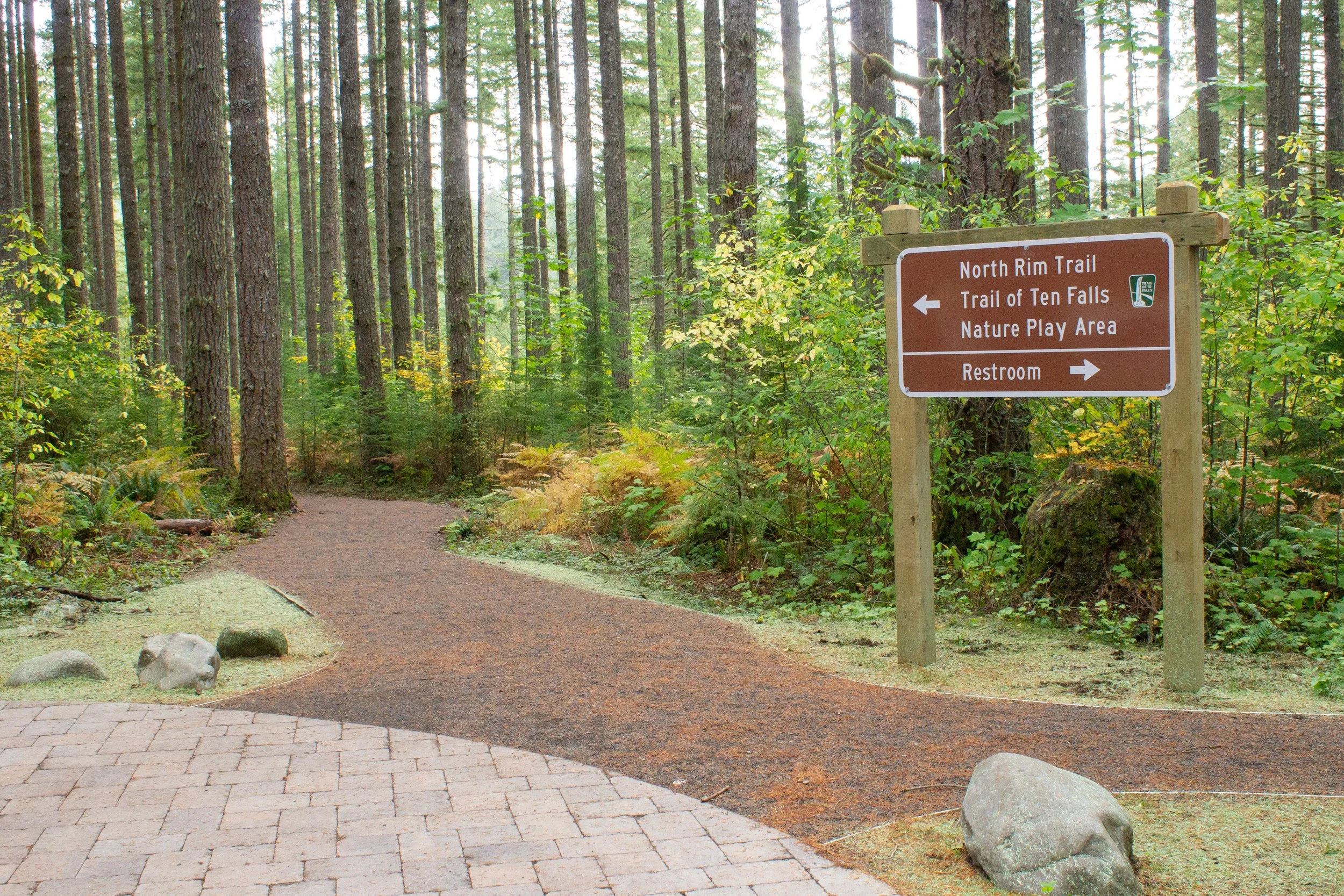
A sign at the trailhead points to the North Rim Trail
After a short walk on the crushed gravel trail, you’ll reach the junction with the Twin Falls Trail. Ignore it and keep left on the North Rim Trail toward the North Falls Viewpoint.

Head toward the North Falls Viewpoint
A quick note on the trail. The North Rim Trail was designed to be an accessible hiking trail that would meet the needs of most visitors. It is wide, even, and well-maintained, without barriers like steps or large rocks. Although never steep, it’s not totally flat, nor is it paved. It might still be challenging with some mobility devices.

Play area on the North Rim Trail
After another 0.1 miles or so, you’ll see the play area. Here, you can either continue past it or wander through the animal-themed play stations inspired by the park’s wildlife. On this optional 0.25-mile loop, small hikers can crawl through logs and perch in a giant bird’s nest. Natural materials help the play equipment blend in with the surrounding forest.

Look for an abundance of mushrooms along the trail in the fall
As you walk, look for wildflowers beneath the sword ferns along the trail in summer. In fall, white, orange, and purple mushrooms contrast with the yellow leaves of the changing undergrowth. The thick moss covering tree trunks and branches is a testament to the age of the forest.

The North Rim Trail explores a dense and mossy forest
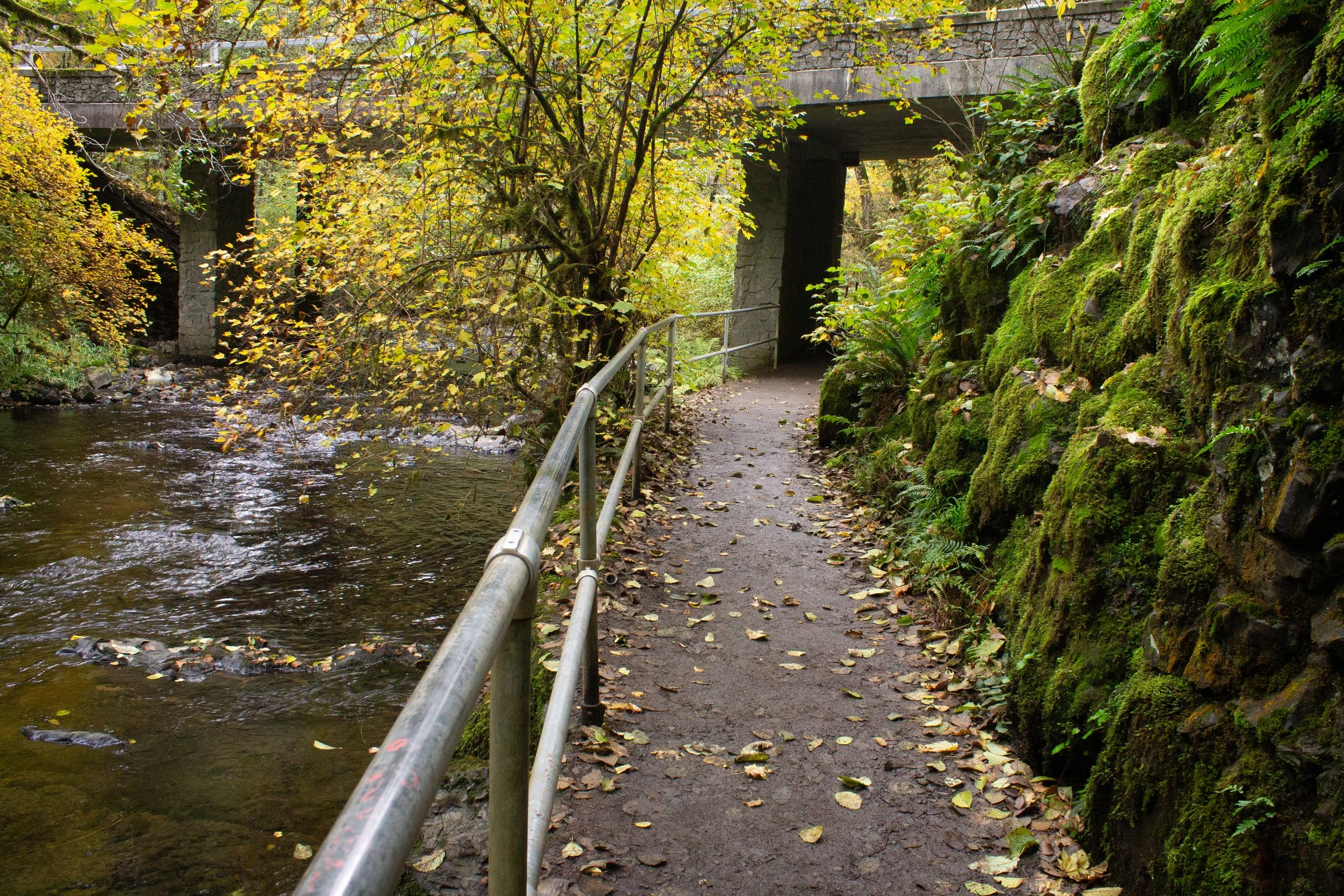
Just past the play area, you’ll see a few picnic tables in a small clearing. Soon after, cross a wooden footbridge over a small creek. The trail meanders gently beneath a canopy of towering Doug firs and big-leaf maples for about 0.4 miles. Once you cross the second footbridge, you will be close to your destination.

Cross a second footbridge and you’re almost there
As you approach the viewpoint, the trail rounds a corner, building anticipation for the scenery just ahead. After the relaxed stroll through the forest, it’s hard not to feel excited by the drama of the canyon just past the giant fir trees. A guardrail lines the viewpoint, making the canyon rim safe for the youngest hikers.

North Falls Viewpoint
From the viewpoint, you’ll see North Falls make its spectacular 136-foot plunge over a basalt cliff. Multiple lava flows covered this area with molten basalt millions of years ago. A thin sedimentary layer between the basalt layers is softer and more easily eroded, creating a deep recess behind North Falls. Today, the Canyon Trail passes behind the falls in this recess. Look for large basalt boulders at the base of the falls. Erosion from below makes the lip of the falls unstable and rocks more likely to tumble.

North Falls
After seeing the North Falls Viewpoint, you can head back the way you came or continue to make a 2.8-mile loop. There are a few steps to climb if you’re continuing past the viewpoint, marking the end of the accessible portion of the trail.
Make it a loop
Distance: 2.8-mile loop
Elevation gain: 300 feet
Difficulty: Moderate
Pass required: Oregon State Park Pass
Dog friendly: No, dogs are not allowed on Canyon Trail or Twin Falls Trail. They can go as far as Upper North Falls.
ADA access: No, not past the North Falls Viewpoint.
Season: Year-round
Basic directions:
Take the North Rim Trail as described above.
Continue past the North Falls Viewpoint until the North Falls Trailhead parking lot. Cross the footbridge on the other side of the parking lot.
Optional: Take a left to make a 0.3-mile detour to Upper North Falls, then return to the bridge.
Take the Canyon Trail to pass behind North Falls.
Continue 1.1 miles on the Canyon Trail until the junction with the Twin Falls Trail, then take a right.
Follow the Twin Falls Trail 0.5 miles until you return to the North Canyon Day-Use Area.

Mushrooms make a lovely foreground for Upper North Falls
The details:
The North Rim Trail connects to the Canyon Trail and the Twin Falls Trail, creating a great new loop hike in Silver Falls State Park. An optional 0.6-mile spur will bring you to Upper North Falls along the way.

Look for a footbridge by the North Falls Trailhead parking lot
From the North Falls Viewpoint, continue about 0.1 miles on the North Rim Trail until you reach the North Falls Trailhead parking lot. There are restrooms here if you need them. Take the wooden footbridge on the other side of the parking lot to cross the North Fork of Silver Creek.
Trail to Upper North Falls
If you have the time and energy to do the spur, take a left just after the footbridge. The trail will pass under the road and then head 0.3 miles through the woods next to the creek. It ends at the ethereal, 65-foot Upper North Falls, which tumbles in front of a basalt cliff as a thin curtain of water. Besides being one of the prettiest waterfalls in Silver Falls State Park, it is also one of the least crowded. You can take your time near the falls and explore the rugged basalt shoreline along the creek. On a hot summer day, it’s hard to resist wading in the cool water.
This waterfall is the only one in Silver Falls State Park you can visit with your dog. If you’re hiking with your dog, turn around here rather than continuing the loop.

Upper North Falls
After seeing Upper North Falls, return on the spur trail to the footbridge. Take a left and look for a split in the trail where the Rim Trail and Canyon Trail separate. Keep right to take the Canyon Trail.

Trail to North Falls
The trail hugs a cliff as it descends into the canyon. You’ll soon reach a stone staircase next to the mossy cliff where maidenhair ferns grow on rough basalt. Gaps between the Doug firs to the right of the stairs allow glimpses of the canyon’s steep contours.

Stairs descend to North Falls
After the stairs, the trail levels out again as you approach North Falls. You may have to duck under the ceiling of chunky basalt as you begin to pass behind the falls.

Behind North Falls
The trail behind North Falls is one of the most extraordinary sights in Silver Falls State Park. As you look past the plunging waterfall, you’ll see the North Fork of Silver Creek flow past fallen boulders at the base of the canyon. In fall, big-leaf maples add vibrant yellow to the forested slopes that rise from either side of the creek. Looking back toward the recessed cliff, you can see the deeply eroded sedimentary rock between layers of basalt. This thin sedimentary layer contains the remains of a forest destroyed by lava flows. You can linger on the bench behind the waterfall if you’re lucky enough to find it free.

North Falls
After passing behind North Falls, you’ll get a final picture-perfect view of its plunge. From here, continue on the Canyon Trail for 1.1 miles. This trail follows the North Fork of Silver Creek, where you can spot fern-covered boulders and picturesque cascades through gaps in the trees.

The Canyon Trail follows the North Fork of Silver Creek
Just over a mile past North Falls, you’ll reach the junction with the Twin Falls Trail and a partial view of Twin Falls. To see the 31-foot waterfall, head to the guardrail next to the creek. The view is a bit underwhelming since the angle prevents you from seeing more than a hint of the waterfall.

Partial view of Twin Falls
After (sort of) seeing Twin Falls, look for the sign pointing you toward the Twin Falls Trail and start heading uphill. This trail climbs for 0.5 miles through the forest and will bring you back to the North Canyon Day-Use Area. Look for a bench about halfway to the top.

Twin Falls Trail
Longer hike options
From Twin Falls, continue on the Canyon Trail past the Twin Falls Trail to Double Falls and Lower North Falls. You’ll pass Middle North Falls and Drake Falls on the way. Return to Twin Falls and then take the Twin Falls Trail back to the parking lot. The total distance will be a little over 4 miles.
To do a modified version of the Trail of Ten Falls that will bring you to all the park’s waterfalls, continue on the Canyon Trail past the Twin Falls Trail until you reach South Falls. Follow the Rim Trail from the South Falls Day-Use Area for 0.9 miles, then take a left on the Winter Falls Trail. After 0.5 miles on the Winter Falls Trail, take a right onto the Canyon Trail. Walk 0.3 miles, then take a left onto the Twin Falls Trail to return to the parking lot. The total distance will be a little over 8 miles.
More easy things to do at Silver Falls State Park
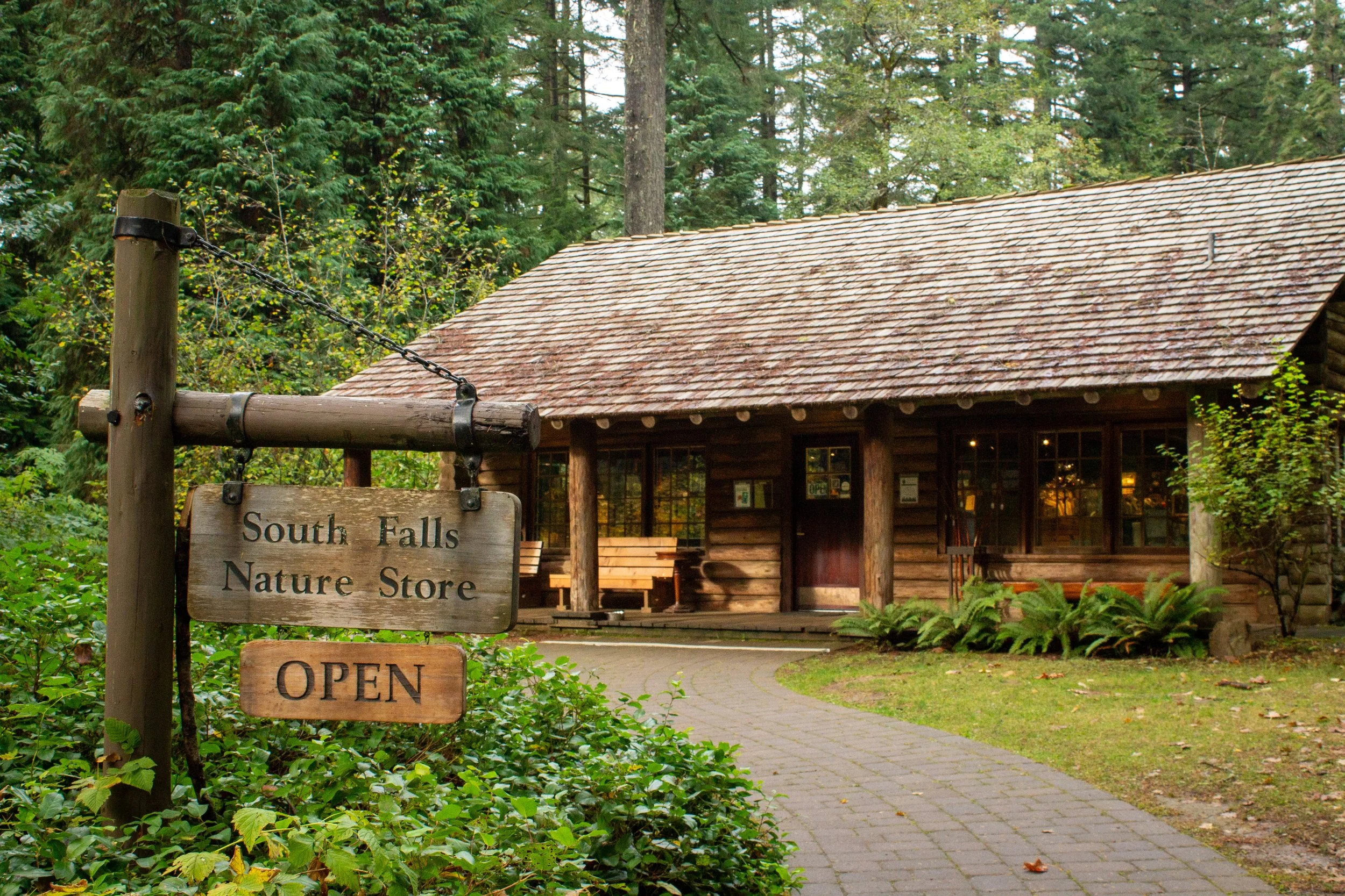
Gift shop near South Falls
Since the North Rim Trail is a short hike, you might also want to explore the south side of Silver Falls State Park starting from the South Falls Day-Use Area. Here, flat paved trails lead to a covered picnic shelter, the South Falls Lodge and Cafe, and the park’s log cabin gift shop.

South Falls
Once you get past the buildings, you’ll be able to look over the top of South Falls from an accessible viewpoint. If you’re okay with uneven terrain, follow the unpaved trail into the canyon to pass behind the magnificent 177-foot South Falls, the most impressive waterfall in Silver Falls State Park.

A trail passes behind South Falls
A short (about 0.2-mile) loop will bring you behind South Falls and then back to the day-use area. For more distance and one more waterfall, you can continue on the Canyon Trail for a little less than a mile to Lower South Falls, then return using the Maple Ridge Trail to make the hike into a 2-mile loop.
Enjoy your day at Silver Falls State Park!
With love,
Emma
Explore nearby

For a less crowded alternative to Silver Falls State Park, try out McDowell Creek Falls County Park.

Check out the other waterfall hikes in Silver Falls State Park.