

The Lewis River’s Magnificent Waterfalls


The Lewis River Falls Trail is one of the most spectacular waterfall hikes in the Pacific Northwest. While the entire trail is long, a gentle 6-mile hike will bring you to three major waterfalls plus a few bonus falls along the way. In late spring, woodland wildflowers fill the undergrowth. In summer, the shady trails and cold water are idyllic places to cool off. It takes some planning to get here. It’s not close to anything and yet you still need two different passes to park. Once you see the waterfalls, all will be forgiven and you’ll forget the hassle it took to reach them. Here is everything you need to know about visiting the Lewis River Recreation Area in Washington’s Gifford Pinchot National Forest.

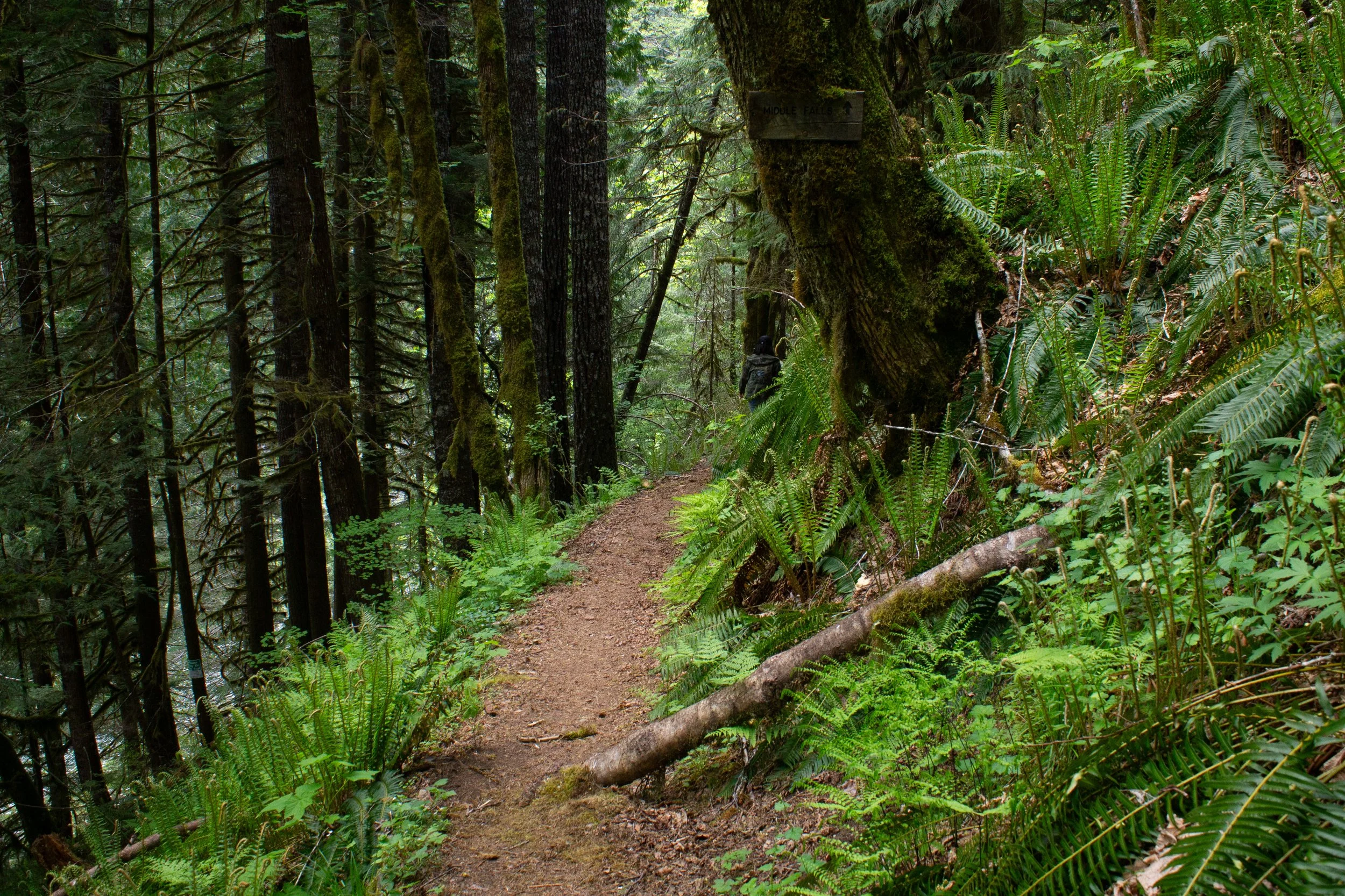
Middle Falls
Know before you go
Between June 15th and September 15th, you need a Lewis River Recreation Area Ticket to park at the Lewis River trailheads. The ticket costs $2 and is good for the specific day you reserve. You need to print the ticket and have a physical copy on your dashboard. As someone without a printer, I visited in May.
Anytime you park in the Lewis River Recreation Area, you need a NW Forest Pass ($5/day) or America the Beautiful Pass. Buy a pass before arriving.
The Lewis River Recreation Area is usually inaccessible due to snow in the winter.
Leashed dogs are welcome on the trail.
Restrooms and a picnic area are at Lower Lewis River Falls near the campground.
There is an unpaved road on the way to the Lewis River Recreation Area that is bumpy but doable in a low-clearance vehicle.
Many trees have fallen on the Lewis River Trail. Parts of the trail require climbing over or ducking under trunks. With one notable exception north of Upper Falls (more on that later), none were major obstacles.
The Lewis River Trail is a shared-use trail for hikers and mountain bikers. Given the number of downed trees, I’d say it’s better for hiking than biking in its current state.

The trail follows the Lewis River
Trailhead options
The entire Lewis River Trail is 14 miles one-way, but multiple trailheads let you hike as much or as little as you want. The coolest waterfalls are between the Lower Lewis River Falls Trailhead and the Quartz Creek Trailhead. Here are the starting point options:
Crab Creek Trailhead. This trailhead adds 3 miles of roundtrip distance without adding any waterfalls, so I wouldn’t start here if you’re trying to minimize hiking. This part of the trail is flat and scenic. It has good views of the Lewis River, including a couple of river access opportunities. It also was the only part of the trail without downed trees when I visited. In total, it’s about 9 miles out and back to reach all the waterfalls from this trailhead, ending with Taitnapum Falls.
Lower Lewis River Falls Trailhead. Most people start here. It’s the most developed trailhead with restrooms and a picnic area. Plus, you’ll start the hike at a phenomenal waterfall viewpoint. From here, 6.6 miles out and back will bring you to all the waterfalls.
Middle Falls Trailhead. From this trailhead, a 0.8-mile out-and-back hike will take you to Upper Copper Creek Falls and Middle Falls.
Quartz Creek Trailhead. A 1-mile out-and-back hike will take you past Taitnapum Falls to two viewpoints overlooking Upper Lewis River Falls. Another 6 miles out and back would bring you to the rest of the waterfalls, ending at Lower Lewis River Falls. Note that the trail was completely blocked by a fallen tree about 0.25 miles from the trailhead when I visited.

The Lewis River Trail is shaded throughout
On the Lewis River Trail
Distance: 6.6 miles out-and-back from Lower Lewis River Falls to Taitnapum Falls (9 miles out-and-back from Crab Creek Trailhead to Taitnapum Falls)
Elevation gain: 500 feet (or 1,000 feet)
Difficulty: Moderate
Passes required: You need two separate passes to park in the Lewis River Recreation Area during the summer.
Northwest Forest Pass or America the Beautiful Pass (always required)
Lewis River Recreation Area Ticket (June 15th to September 15th)
Dog friendly: Yes, leashed dogs are welcome on the trail.
ADA access: No
Season: Late spring through fall

Oregon grape blooms around the trail in May
The details
Crab Creek Trailhead to Lower Lewis River Falls: The Crab Creek Trailhead is non-descript and easy to drive past. It has no restrooms or other amenities. Park along the shoulder and look for the trail on the same side of the road as the parking signs.

Crab Creek Trailhead
The trail begins in a Doug fir, hemlock, cedar, and big-leaf maple forest. I’ve seen it called an old-growth forest. You’ll see some large trees along the way, but old-growth might be overstating it. It is a peaceful and secluded mature forest. The trail is a flat and gentle dirt path that muffles the sound of footfalls, adding to its tranquility.

Lewis River Trail
An unexpected treat of my late May visit was the abundance of wildflowers in the undergrowth, especially vanilla leaf, Oregon grape, and bleeding hearts. Some fading purple trillium petals remained even with summer just around the corner. Salmonberry flowers add fuchsia splashes to the surrounding green. Expect berries in summer.

Vanilla leaf blooms in the undergrowth
The trail follows the Lewis River. You’ll see glimpses of it along most of the hike. Every so often, a gap in the trees gives you an unobstructed view. A couple of points toward the beginning of the trail are easy places to get down to the water. If it’s hot, you can wade. You’ll see the riverbed in detail through the remarkably clear water.

Salmonberry bushes flower near the Lewis River
The trail gradually gains some elevation as it approaches the first waterfall, Lower Lewis River Falls. You’ll leave the riverbank as you climb and see the water from above.

The trail follows the river
This first part of the trail is well-maintained and free of fallen trees. The only tricky part is a washed-out section that requires a little scramble. It wasn’t hard on foot, but a family with small children on bikes was struggling here when I visited.

The only obstacle between Crab Creek Trailhead and Lower Falls
Just before you reach Lower Falls, an informal little spur trail descends steeply to the right. Following it will bring you down to the water by way of a couple of fraying ropes. I wouldn’t suggest it in spring. The water is too high and moving too fast to get down to the shore. The rocks near it are wet, steep, and slippery. Better views of the waterfall are up ahead. I took the picture below one-handed while hanging from one of the ropes. I wouldn’t do it again.

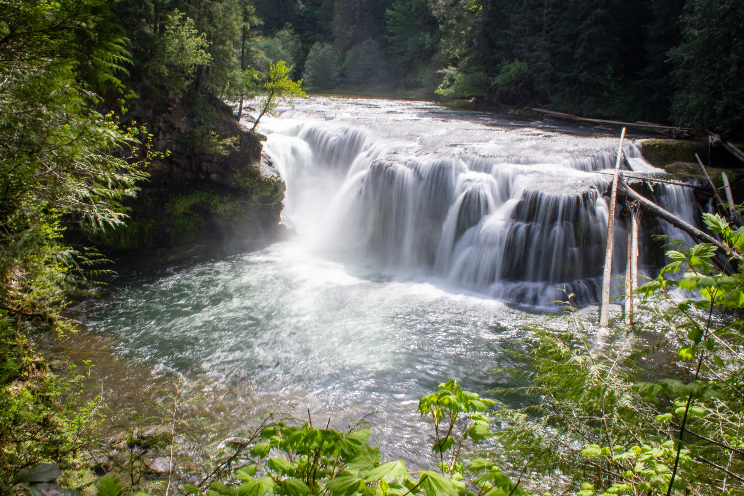
Lower Lewis River Falls
Lower Falls to Middle Falls: You’ll hear the roar of Lower Lewis River Falls before you reach it. This powerful waterfall is 43 feet high and 200 feet wide. In spring, water surges over it. In late summer, it flows as countless rivulets over the rocky ledge that is a legacy of ancient lava flows.

Lower Falls
Fenced viewpoints let you see the waterfall safely from above. There’s a bench that is the perfect snack break spot.

My friend Denise and her dog Milo admire Lower Falls
As you make your way along the fence, you’ll see Lower Falls from different angles. When the sun hits the water, it’s a translucent aquamarine. The Lewis River begins on the slopes of Mt Adams, fed by glacial meltwater. Its color comes from glacial flour, the tiny pieces of mountain rock that the glacier grinds down and the river transports.

Lower Falls with a little rainbow
At the end of the split rail fence, you’ll see the top of the falls. Stay out of the water here, it’s moving too fast. There is a safe wading spot just ahead.

The Lewis River approaches the Lower Falls
Just past Lower Falls and its campground (and bathroom), you’ll see the trail split and a boardwalk heading right.

This boardwalk leads to a good wading spot
The boardwalk leads to a sandy riverbank and water that is calm enough for wading on a hot day. This water was a glacier not long ago, so expect it to be cold. Across the river is an eroded cliff of volcanic rock. At the end of this short beach, a staircase leads back up to the main trail.

Calm and scenic beach for wading
Now you’re heading to Middle Falls. The trail begins to climb above the river again. You’ll pass a short and steep spur trail to your right that leads to a river overlook.

Spur trail to an overlook, not necessarily worth it
It’s fairly overgrown, but a dogwood tree was blooming when I visited. Be careful with kids here. You’re essentially on a bit of soil hanging over the river.

Dogwood flowers were a surprise next to the river
Back on the main trail, wildflowers abound. Fairy slipper orchids and false Solomon’s seal join the vanilla leaf and bleeding hearts in the undergrowth.

Fairy slipper orchids
Besides wildflowers, I saw tons of mushrooms along the trail, somewhat of a surprise in May. I’m by no means an expert in identification, but I think most were yellow-orange fly agarics (below).

Beautiful (and poisonous) mushroom near the trail
You’ll also get regular views of the Lewis River through the trees.

Lewis River
This part of the trail had a lot of downed trees when I visited. Some you can duck under. Most, you climb over. My friend’s dogs made it okay. None are major obstacles, but they will slow you down.

Expect many downed trees between Lower and Middle Falls
A little under a mile from Lower Falls, you’ll cross a wooden footbridge over a seasonal waterfall.

Cross here
Then, you’ll walk up a small ridge on the way to the Middle Falls Trailhead.

Approaching the Middle Falls Trailhead
Cross the little parking area (no amenities) and follow the sign for Middle and Upper Falls. Don’t be discouraged when you don’t see Middle Falls right away. It’s about a half mile ahead.

Middle Falls Trailhead
You’ll soon reach another footbridge, this one over Copper Creek. As you cross, you’ll see the lip of Upper Copper Creek Falls as it tumbles over a cliff. Better views of the falls are just ahead.

Bridge over Copper Creek
Best in spring, Upper Copper Creek Falls makes a magical 25-foot single plunge over a cliff covered with moss and maidenhair ferns. In late summer, this waterfall can become an underwhelming trickle.

Upper Copper Creek Falls
About 0.2 miles after Upper Copper Creek Falls, you’ll reach a trail junction. Go right to take the short (0.1-mile) spur down to Middle Falls.
Spur trail to Middle Falls
A broad ledge like Lower Falls, Middle Falls is more impressive for its 300-foot width than its 33-foot height. Although it doesn’t have quite the same wow factor as Lower Falls, it is lovely. Plus, you’ll get close to it.

Middle Falls
You can walk a short way downstream to see more cascades along the river. These are most impressive in spring but also most difficult to approach. The riverbank is made of sloping slippery rocks next to fast-moving water. Explore with caution. If the water level is low, wading into the river will give you the best view of the falls.

Cascades near Middle Falls
After seeing Middle Falls, head back to the trail junction.

From Middle Falls, return to Lower Falls or continue to Upper Falls
Upper Falls and Taitnapum Falls: Back at the junction, a sign points the way to Upper Falls. In 0.8 miles, you’ll reach the first of two viewpoints for the 58-foot waterfall. Continue 0.2 miles to see the second viewpoint. About 0.3 miles farther ahead is Taitnapum Falls, which makes for a good turnaround point.
And now to explain why the pictures stop here. Because of a chronic injury, I can’t hike more than about 5 miles. I started at the Crab Creek Trailhead, so was already pushing my limits by ending at Middle Falls. Okay, no problem. I planned to drive to the Quartz Creek Trailhead to see the last two waterfalls. Buuuut, about a quarter mile from this trailhead, a fallen tree blocked the path. I had climbed over at least dozen logs by this point, but this tree was different. Pine needles and branches as far as the eye can see. So, I have some unfinished business here. From what I’m seeing on All Trails, people are making it through from Middle Falls. For now, I’d approach Upper Falls this way rather than from the Quartz Creek Trailhead.
Camping
The campground is by Lower Lewis River Falls
Lower Lewis River Falls has a campground in the woods near the waterfall. Campsites are available from May 15th to Sept 23rd and cost $20-40/night. If you’re camping, you do not need an additional parking reservation to park at your campsite. There are tent and RV sites but no hookups. Composting toilets, picnic tables, grills, and drinking water are available at the campground.
Find details at recreation.gov.
Getting there
It is a long, slow drive from Portland to the Lewis River Recreation Area. It’s worth it, but expect to get stuck behind slow-moving trucks on roads without passing lanes and road construction delays in the middle of nowhere. Get comfortable and have a good playlist downloaded.
To reach the Lewis River Recreation Area from Portland, you can either start on I-5 and then head east or start on I-84 and cross the Bridge of the Gods to head north. I prefer I-5 because it avoids the bridge tolls. Both ways take a little over 2 hours.
From I-5 N, take Exit 21 for WA-503 (Lewis River Rd). Follow Lewis River Rd for 30 miles. Then, continue onto Rd 90 and drive for 13 miles. The Lewis River trailheads will be on your right. You’ll pass Crab Creek Trailhead first, then the Lower Lewis River Falls, Middle Falls, and Upper Falls parking areas in that order.
From Seattle, take I-5 S until Exit 22. Then continue on Lewis River Rd as described above. The drive from Seattle takes 4 hours.

Crab Creek Trailhead parking
Enjoy your hike to the Lewis River waterfalls!
With love,
Emma
Explore nearby

Hike to the stunning Falls Creek Falls.

Check out the incredible hike to Goat Marsh Lake.

Find the best things to do around Mt Adams.

See all the best waterfalls in Washington’s Columbia Gorge.