

20 Incredible Short Hikes near Bend

Disclosure: post contains affiliate links.
A little over three hours from my home in Portland, Bend is one of my favorite weekend getaways. Once I’m there, I can’t wait to start hiking. With easy access to both the Cascade Mountains and Oregon’s high desert, the trails around Bend have fantastic variety. Here are my favorites, chosen for hike awesomeness and convenience to the city. I grouped the hikes by region in case you want to tackle more than one in a day. Most are easy and family-friendly. Everything is under 5 miles long and within 90 minutes of Bend. Enjoy!

The Deschutes River Trail to Benham Falls is a great year-round hike
Tips for hiking near Bend
Most trails in and around Bend don’t have much shade. Wear sunscreen and bring a water bottle.
Watch for rattlesnakes on high desert trails (think juniper and sagebrush country).
For hikes within Bend, sneakers are fine. Outside the city, it’s a good idea to wear hiking boots. I’ve had great luck with my hiking boots. There is a similar pair for men.
Check for seasonal closures. Some trails will be inaccessible in winter, especially those at higher elevations.
Many hikes near Bend require seasonal wilderness permits in the summer. In my experience, they are very hard to get. I left these hikes off the list because, honestly, I’ve never been able to get a permit. Check trailhead requirements before heading out.
Hikes in Bend
1. Pilot Butte

The trail to Pilot Butte’s summit has great views of the Cascades
Distance: 1.8 miles out and back
Elevation gain: 450 feet
Difficulty: Easy
Kid-friendly: Yes
Dog-friendly: Yes, leashed dogs are welcome on the trail.
Pass required: None
ADA access: A paved trail at the base of the butte won’t bring you to the viewpoint at the summit but has gentle grades. Accessible parking, restrooms, picnic area, and playground.
You can drive to the top of Pilot Butte seasonally, from around the end of April to Nov 1st.
Restrooms: Yes
Season: Potentially year-round. The trail can get snow and ice in winter.

From left to right: Mt Bachelor, Broken Top, and the Three Sisters
The short and sweet hike up Pilot Butte highlights what is special about Bend. The 480-foot butte is an extinct volcano with a viewpoint at its summit. You can reach the top by car in summer or on foot all year long. Even when the road is open, most people choose to walk up. The views from the trail are open and expansive from start to finish. You’ll see the town of Bend sprawling out in all directions. In the distance are the Cascade Mountains. Pilot Butte is an urban hike rather than a wilderness retreat. The trails are bustling, even on weekdays. Houses and roads surround the base of the butte. If you can overlook the lack of seclusion, the vibe is cheerful. Plus, where else has a playground at the base of a volcano?
2. Shevlin Park

Tumalo Creek
Distance: 2 or 4.5-mile loop
Elevation gain: 200 feet
Difficulty: Easy
Kid-friendly: Yes
Dog-friendly: Yes, leashed dogs are welcome on the trails.
Pass required: None
ADA access: The Tumalo Creek Trail is unpaved but flat and even. Find a good detailed description from Oregon Adaptive Sports here.
Restrooms: Yes
Season: All year

Shevlin Loop Trail
Shevlin Park in Bend’s northwest corner is the perfect destination when you want to feel like you’re in the woods without leaving the city. The kid and dog-friendly Tumalo Creek Trail follows the gentle Tumalo Creek through a shady pine forest. On hot days, you can cool off by dipping your feet in the chilly water. A couple of footbridges along the trail cross the creek and connect with the Shevlin Loop Trail. Take the first bridge for a nice and easy 2-mile loop or the next bridge for a 4.5-mile loop. After the hike, the picnic area is a lovely spot for lunch. Or, head five minutes down the road to reach the restaurants of Bend. Washington Dining & Cocktails has a fantastic patio.
3. Deschutes River Trail
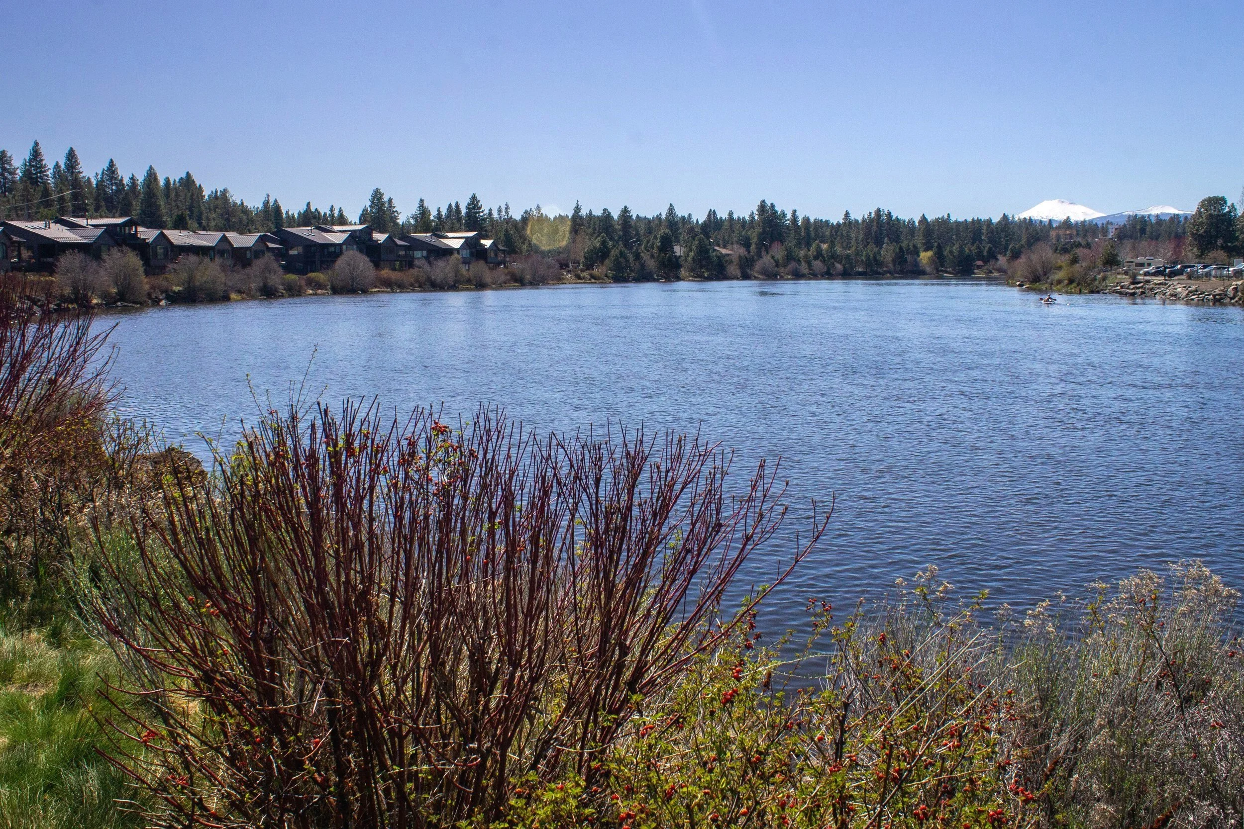
A scenic hiking trail follows the Deschutes River in Bend
Distance: a 2.7-mile loop with longer hiking options
Elevation gain: Minimal
Difficulty: Easy
Kid-friendly: Yes, and stroller friendly.
Dog-friendly: Yes, leashed dogs are welcome on the trail.
Pass required: None
ADA access: The trail from the Old Mill District is flat, paved, wide, and even without barriers like steps. Accessible parking and restrooms. If you continue south of Farewell Bend Park, the trail becomes unpaved and less even.
Restrooms: Yes
Season: All year

Ducks and geese often hang out near the Deschutes River Trail
The Deschutes River Trail is one of Oregon’s most confusing trail names since it stops and starts about a gazillion times. Within Bend, a fun section of the trail starts at the Old Mill District and follows the river south. You’ll soon leave the stores and restaurants (and any dedicated shoppers in your group) behind as you stroll down the riverbank. In summer, people paddle and float downstream, sometimes with pleasingly silly inflatables. The river is also a favorite of ducks and geese. Continue until the Farewell Bend Park, then take the footbridge across the river to Riverbend Park. Head north to return on the other side of the river. There will be another bridge that will take you back to your starting point. After the hike, have a glass of wine on the patio at Va Piano or an ice cream cone from Ben and Jerry’s.
Hikes East of Bend: High Desert
4. Oregon Badlands

Ancient Juniper Trail
Distance: 3-mile loop
Elevation gain: 100 feet
Difficulty: Easy
Kid-friendly: Yes
Dog-friendly: Yes
Pass required: None
ADA access: I’d say no. The trail is even and flat, but the sandy surface would make it difficult with a wheelchair or mobility device.
Restrooms: No
Drive time from Bend: 20 minutes
Season: Potentially all year. Best in spring and fall when temperatures are mild.

Sand lilies in the Oregon Badlands
Despite being only 20 minutes from downtown Bend, the Oregon Badlands feel wild and remote. They’re also (relatively) uncrowded for being so scenic and close to town. Although the Badlands cover a large area, a short hike is enough to get a sense of them. The trails explore a high desert landscape full of sagebrush, rabbitbrush, and gnarled juniper trees. Some of the trees you see along the trail are over 1,000 years old. In spring, wildflowers like dainty sand lilies appear in the volcanic soil. Mt Mazama covered this area in ash during its eruption 7,700 years ago, the same one that formed Crater Lake. Meanwhile, the rock you see came from Newberry Volcano’s lava around 80,00 years ago.
The Flatiron Rock Trailhead is a good starting point for a short hike in the Oregon Badlands. From here, try the 3-mile Ancient Juniper Trail Loop for an easy and relaxing hike past some venerable trees. For more of a destination, try out the 6-mile hike to Flatiron Rock, which ends at a distinctive-looking rock formation and Cascade Mountain views.
5. Chimney Rock

Chimney Rock
Distance: 2.6 miles out and back
Elevation gain: 600 feet
Difficulty: Easy
Kid-friendly: Yes but be aware of some drop-offs near the trail.
Dog-friendly: Yes
Pass required: None
ADA access: No
Restrooms: Yes (although they were closed when I visited).
Drive time from Bend: 50 minutes
Season: Best from fall to spring. This unshaded trail gets hot and dusty in summer.

Crooked River Canyon
Note: Check for closures before visiting. The trail is expected to close for renovations on Memorial Day or 2024. I haven’t seen a reopening date yet.
The hike to Chimney Rock is a hidden gem where you can find spectacular scenery without the crowds. Rugged, beautiful, and less than an hour from Bend, I’m surprised this trail doesn’t get packed. Yet when I visited on a beautiful spring day, it was all but deserted. In a little over a mile, you’ll see the dramatic cliffs of the Crooked River Canyon and stunning Cascade Mountain views on your way to the strange basalt tower that is Chimney Rock. In spring, butterflies flutter across the trail as they move between wildflowers like prairie stars, phlox, and yellow bells. Before or after the hike, cross the road and stop by the observation platform over the Crooked River. If you’re lucky, you might see a heron fishing.
Hikes North of Bend: Redmond to Madras
6. Cline Falls

Cline Falls
Distance: 1.2 miles out and back
Elevation gain: Minimal
Difficulty: Easy
Kid-friendly: Yes
Dog-friendly: Yes, leashed dogs are welcome on the trail.
Pass required: None
ADA access: Limited. Trail to the falls is unpaved.
Restrooms: Yes
Drive time from Bend: 25 minutes
Season: All year. The waterfall will look best in winter and spring.

Cline Falls has a few icicles in winter
With a name like Cline Falls State Scenic Viewpoint, you can understand why I thought Cline Falls would be there. It’s not. Or at least, not right there. The parking lot for the “viewpoint” is next to the Deschutes River. It’s a pretty place with picnic tables and, often, ducks swimming nearby, but it’s not especially interesting or dramatic. Cline Falls is about a half mile away and well worth the short and easy trek to seek it out. From the parking lot, head back toward the entrance as though you were leaving. Take the trail along the river under the highway. You’ll soon reach 20-foot Cline Falls tumbling over a chunky basalt ledge. Past the falls, you can explore a short stretch of the riverbank. The hike doesn’t take long but is easy to combine with nearby attractions like Smith Rock State Park (#7), Scout Camp (#8), or the Peterson Rock Garden.
7. Smith Rock State Park

Smith Rock
Distance: 0.5+ miles
Elevation gain: Minimal to about 1,000 feet depending on the trail.
Difficulty: Easy to difficult
Kid-friendly: Yes for most trails. I’d skip the Misery Ridge Trail with children younger than 8.
Dog-friendly: Yes, leashed dogs are welcome on the trails.
Pass required: Oregon State Park ($5/day or $30/year). You can buy a pass at the park.
ADA access: The Rim Rock Trail is unpaved (crushed gravel), flat, and even with gentle grades. There is a steep descent into the canyon to reach most of the other trails. Find detailed information in this article by Disabled Hikers.
Restrooms: Yes
Drive time from Bend: 35 minutes
Season: Potentially all year. Temperatures and crowds can be intense in summer. Smith Rock has some of the most popular hikes near Bend. Spring and fall are great times to visit. Winter can be good as well, although the trails sometimes get snow and ice.

Misery Ridge Trail
I’m smashing the trails at Smith Rock State Park into a single entry so they don’t take over the list, but there are several great short (and long) hike options here. It’s one of those places where you can make your day as laidback or strenuous as you want. For the full list of options, check out my article on the best hikes in Smith Rock State Park. Here are a few short hike highlights:
You’ll see the Rim Rock Trail just after stepping out of the car. It follows the rim of the Crooked River Canyon without descending into it, keeping the hike flat, easy, and family-friendly. You’ll have great views of Smith Rock along the way.
The Canyon Trail descends 0.5 miles from the parking lot to the Crooked River. Use this short but steep trail to reach the base of Smith Rock and the hiking trails there. Keep in mind that it’s a sunny and steep walk back up when you’re done.
The Misery Ridge Trail is the most famous hike in Smith Rock State Park. It can be done as a 2-mile out-and-back or 4-mile loop. Although short, it is not easy. The drop-offs near the narrow trail can also be harrowing. I saw a hiker freeze coming down because of the heights. He made it okay, but don’t underestimate this trail because of its distance. If you’re good with steep trails and heights, the views are breathtaking.
The River Trail and Wolf Tree Trail explore the base of Smith Rock and the Crooked River in either direction. Both are easy, family-friendly, and packed with breathtaking scenery.
8. Scout Camp Trail

The Scout Camp Trail descends to the Deschutes River
Distance: 2.2-mile lollipop loop
Elevation gain: 600 feet
Difficulty: Moderate. Be prepared for a small amount of rock climbing.
Kid-friendly: Better for older children due to steep trail sections and drop-offs.
Dog-friendly: Yes
Pass required: None
ADA access: No
Restrooms: No
Drive time from Bend: 45 minutes
Season: Potentially all year. Can be hot in summer. The trail rarely gets ice, but avoid it when it does.

Deschutes River
The Scout Camp Trail is a hike I visited without any expectations beyond getting outside on a cold and gloomy winter day. Within a half mile, the wild and rugged scenery had blown me away. The hike begins as a gentle stroll through a ponderosa pine forest. After this unassuming start, you’ll reach views of the deep and imposing Deschutes River Canyon, which seems to appear out of nowhere. Shortly after, you’ll begin the loop portion of the trail. Going clockwise, it descends into the canyon and then follows the Deschutes River out to its confluence with the Whychus Creek before returning uphill. Although short, this steep trail feels like an adventure, complete with a rocky scramble or two along the way. While you’re in the area, consider stopping at nearby Steelhead Falls for s bonus short and rewarding hike near Bend.
Hikes West of Bend: Cascades
9. Tumalo Falls

Tumalo Falls
Distance: 0.6-mile lollipop loop
Elevation gain: 150 feet
Difficulty: Easy
Kid-friendly: Yes
Dog-friendly: Yes, leashed dogs are welcome on the trail.
Pass required: Northwest Forest Pass ($5/day) or America the Beautiful Pass. Parking is limited at the trailhead. Arrive early. The road to the trailhead is bumpy but doable in a low-clearance vehicle.
ADA access: Not past the lower Tumalo Falls viewpoint near the parking lot. Accessible parking.
Restrooms: Yes
Drive time from Bend: 25 minutes
Season: June to October. The road to the trailhead closes in winter. You can walk or snowshoe from the winter gate to the trailhead, which adds 5 miles of roundtrip distance.

Tumalo Creek
Tumalo Falls is in the crowded-but-worth-it category of hikes near Bend. The highlight is the park's namesake waterfall, Tumalo Falls, which you can see tumbling as a curtain of water over a basalt cliff from a stunning viewpoint near the parking lot. Take the hiking trail for about a quarter mile to see the powerful 90-foot waterfall from above. You can make a little loop and then head back for an easy 0.6-mile hike. Or, continue through the shady forest, following Tumalo Creek upstream. Most people don’t continue beyond Double Falls, a 2-mile out-and-back hike. If you have the time and energy, you can reach up to 6 more waterfalls in 7 miles. Arrive early on summer weekends to find parking at the trailhead.
10. Clear Lake

Clear Lake
Distance: 4.8-mile loop
Elevation gain: 200 feet
Difficulty: Easy
Kid-friendly: Yes
Dog-friendly: Yes, leashed dogs are welcome on the trail.
Pass required: None
ADA access: No
Restrooms: Yes
Drive time from Bend: 70 minutes
Season: March - October to avoid the snow.

The transparent water of Clear Lake
Mostly known for its rustic resort and campground, Clear Lake also has a lovely hiking trail. Over an easy 5 miles, you’ll make a circle around the lake through conifer forests and fields of lava rock. The most eye-catching highlight is Clear Lake’s water, remarkable for its color and clarity. You can see the lakebed in incredible detail, as though the water were liquid glass. On sunny days, it’s an impossible-looking shade of turquoise. The resort rents boats, which is a great way to explore the lake. Just don’t plan on swimming. Clear Lake owes its clarity to its cold temperature.
11. Sahalie and Koosah Falls

Sahalie Falls
Distance: 2.4-mile loop
Elevation gain: 300 feet
Difficulty: Easy
Kid-friendly: Yes
Dog-friendly: Yes, leashed dogs are welcome on the trail.
Pass required: None
ADA access: Not on the trail, but stop by the Sahalie Falls Viewpoint.
Restrooms: Yes
Drive time from Bend: 70 minutes
Season: Spring to fall

Koosah Falls
Of all the hikes near Bend, the short loop connecting Sahalie and Koosah Falls offers the most waterfall majesty for the distance. The two waterfalls are about a half mile away, connected by a trail that follows the picturesque cascades of the McKenzie River. Since each waterfall has a parking lot, you could visit them without hiking, but you’d miss seeing a beautiful part of the Willamette National Forest. Old-growth cedars, Doug firs, and hemlock shade the trail between the roaring, 80 foot-waterfalls. Thick moss covers the rocks, trees, and both waterfall amphitheaters. Footbridges upstream of Sahalie and downstream of Koosah Falls let you escape the crowds and explore the other side of the river for a 2.4-mile loop hike.
12. Tamolitch Blue Pool

Blue Pool
Distance: 4.2 miles out and back
Elevation gain: 300 feet
Difficulty: Moderate
Kid-friendly: Mostly yes, but be careful near the cliffs around the Blue Pool.
Dog-friendly: Yes, leashed dogs are welcome on the trail.
Pass required: None. Parking fills up FAST on summer weekends. Arrive early.
ADA access: No
Restrooms: Yes
Drive time from Bend: 70 minutes
Season: Spring to fall

McKenzie River Trail
Even in a land of geologic marvels, Oregon’s Tamolitch Blue Pool stands out. Its water comes from Clear Lake by way of the McKenzie River. After acting like a typical river for a stretch, the McKenzie goes underground for several miles. It resurfaces at the Blue Pool and then continues, river-like once more. The nearby Belknap Crater buried a portion of the river when it erupted 1,600 years ago. Thanks to its near-freezing temperatures, the Blue Pool is exceptionally clear. On sunny days, it’s neon turquoise. On cloudy ones, a dark sapphire. A few times a year, heavy rains create a short-lived waterfall. The trail to reach the Blue Pool passes through an old-growth forest and then piles of lava rock as it follows the pearly-blue McKenzie River. It’s the perfect shady hike near Bend on a hot summer day. Just don’t underestimate its popularity. Arrive before 8 AM or after 4 PM on summer weekends to find parking.
Hikes South of Bend: Sun River to Crater Lake
13. Benham Falls

Deschutes River
Distance: 1.7 miles out and back
Elevation gain: 100 feet
Difficulty: Easy
Kid-friendly: Yes
Dog-friendly: Yes. They must be on a leash from May 15 through September 15.
Pass required: Northwest Forest Pass ($5/day) or America the Beautiful Pass. Buy a pass before arriving at the trailhead.
ADA access: The trail is unpaved but fairly even with gentle grades. Accessible parking and restrooms.
Restrooms: Yes
Drive time from Bend: 20 minutes
Season: All year

Benham Falls
We’re back on the Deschutes River Trail, but this hike will feel very different from the trail in Bend. If you’re up for a short drive out of town, the family-friendly hike to Benham Falls has towering conifers, tumbling cascades, and volcanic marvels on the way to a dazzling waterfall. The trail follows a particularly scenic section of the Deschutes River. Across it, you’ll have frequent views of rugged lava rock fields, a legacy of Lava Butte’s eruption. The hike ends at a fenced viewpoint overlooking 25-foot Benham Falls. Since it’s on the Deschutes River Trail, you could continue for much longer, but the waterfall makes a satisfying turnaround point for a short hike. Dillon Falls is the next waterfall on the trail, another 3 miles away.
14. Sunriver Nature Center and Observatory

Nature trail at the Sunriver Nature Center
Distance: About 0.5 miles out and back
Elevation gain: Minimal
Difficulty: Easy
Kid-friendly: Yes
Dog-friendly: Leashed dogs are allowed on the nature trails but not in the indoor spaces.
Pass required: Paid admission (Adult $9, kids 6-12 $6, under 6 free)
ADA access: Nature trails are flat and even, but mostly unpaved with variable surfaces. Parking lot, restrooms, and inside areas are accessible.
Restrooms: Yes
Drive time from Bend: 25 minutes
Season: All year

This enormous swan (Gus) often frequents the Sun River Nature Center
The Sunriver Nature Center and Observatory is more of an activity than a hike but makes for a fun excursion near Bend, especially with kids. There’s a nature trail that explores a wetland area. It’s a great place to spot wildlife like trumpeter swans, herons, and Steller’s jays. Behind the Nature Center, look for birds in the raptor rescue enclosures. Inside, check out the Creature Cave to search for frogs, snakes, and salamanders. During the day, you can look at the sun through the observatory’s telescope. Nighttime events allow for stargazing in an area with little light pollution.
15. Newberry National Volcanic Monument

Big Obsidian Trail
Distance: 0.5+ miles
Difficulty: Variable. Many easy and moderate trails.
Kid-friendly: Yes, many kid-friendly options.
Dog-friendly: Yes, dogs can be on a leash in most areas. They are not allowed in the Lava River Cave. I’d also avoid the Big Obsidian Trail with a dog since it has sharp rocks.
Pass required: Northwest Forest Pass ($5/day) or America the Beautiful Pass. You need a timed entry permit to visit the Lava River Cave (but not other areas of the park).
ADA access: Check out the Lava Lands Visitor Center and the nearby paved trails through the lava rock fields. Or, the first 0.5 miles of the Lava Cast Forest Trail is flat, even, and paved.
Restrooms: Yes
Drive time from Bend: 40-80 minutes. It’s a big park with multiple areas.
Season: June to September
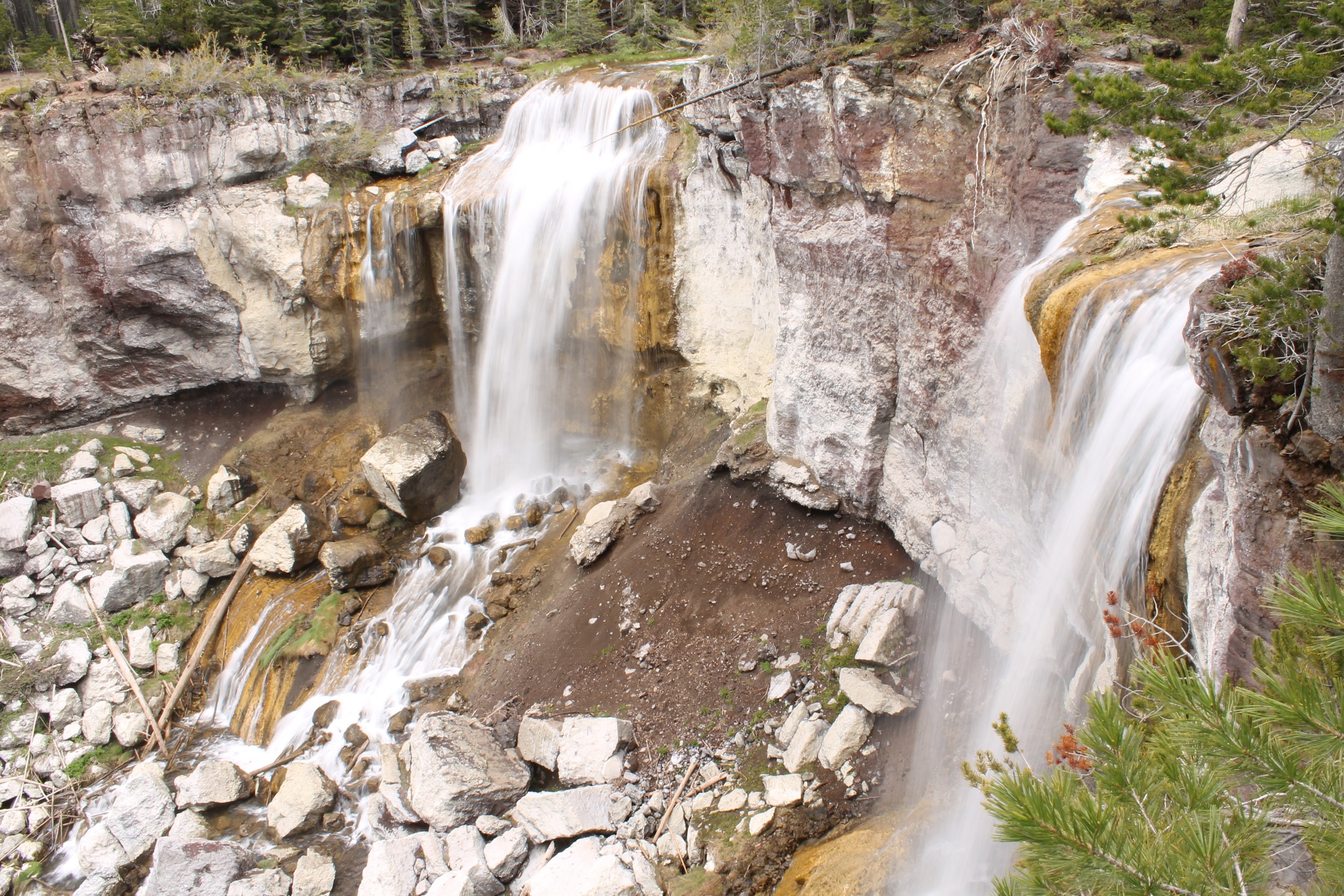
Paulina Falls
Newberry National Volcanic Monument could fill up half the list with excellent hikes. Spread out over multiple locations near Bend, this park highlights the strange geology of the recently active Newberry Volcano. Here are a few great short hike choices:
The Lava Cast Forest Trail makes a 1-mile loop through a field of lava rocks that was once a forest. You’ll see the casts that formed when lava hardened around trees. The stumps are long gone but their imprints remain.
Hike underground on the 2.2-mile out-and-back Lava River Cave hike. Make sure to get a timed entry reservation in addition to the NW Forest Pass before visiting.
Make the 0.6-mile loop on the Big Obsidian Trail, which explores otherworldly hills of pumice and obsidian that erupted only 1,300 years ago.
Take the 0.5-mile trail to Paulina Falls. Both the upper and lower viewpoints are worth seeing.
Little Crater Trail is an easy 1.8-mile trail with views of Paulina Peak, the lakes, and the Big Obsidian Flow.
16. Crater Lake National Park

Views of the Phantom Ship from the Sun Notch Trail
Distance: 0.5+ miles
Difficulty: Variable. Many easy and moderate trails.
Kid-friendly: Yes, many kid-friendly options.
Dog-friendly: Dogs are allowed in the park but not on most hiking trails. The Rim Village Promenade is a fun walk with a dog.
Pass required: $30 entrance fee (good for 7 days) or the America the Beautiful Pass. You can pay at the park entrance.
ADA access: Mostly not on the trails, but there are a gazillion cool viewpoints at Crater Lake. Check out the Glen Godfrey Trail. See all options on the National Park Service’s website.
Restrooms: Yes
Drive time from Bend: 90 minutes
Season: July to October

Cleetwood Cove Trail
One of the most dramatic geologic events in the Pacific Northwest was Mt Mazama’s eruption 7,700 years ago. The scale of this eruption was so enormous that the volcano collapsed, becoming a massive caldera. In other words, one of Oregon’s highest peaks became a really, really big hole. Rain and snowmelt filled the caldera with water, creating Crater Lake. Only 90 minutes from downtown Bend, Crater Lake National Park is full of great short hikes. I won’t dwell too much on the details here because I have an article on my favorite short hikes in Crater Lake National Park. Here’s the quick version:
The Cleetwood Cove Trail is the only hike that will bring you down to the water at Crater Lake. Although just over 2 miles roundtrip, it’s steep enough to be a workout.
The 0.5-mile Sun Notch Trail has the best views of the Phantom Ship, an island of 400,000-year-old andesite that looks like a pirate ship.
The Pinnacles Trail is an easy, 1-mile out-and-back hike that will take you past weird spires of eroded ash-flow tuff.
Do a short section of the Rim Trail to see breathtaking views of Crater Lake, Wizard Island, and the caldera’s rim. The whole thing is very long, so just do as much as you want. None of it is boring.
Hikes Southwest of Bend: Cascade Lakes Byway
17. Todd Lake

Todd Lake
Distance: 1.7-mile loop
Elevation gain: 100 feet
Difficulty: Easy
Kid-friendly: Yes
Dog-friendly: Yes, leashed dogs are welcome on the trail.
Pass required: Northwest Forest Pass ($5/day) or America the Beautiful Pass. You don’t need a wilderness permit to hike the 1.7-mile trail around the lake. If you take the nearby Todd Lake Trail #34, you’ll need a Central Cascades Wilderness Permit from June 15th to October 15th. It’s a rough road to reach the lake but doable in a low-clearance vehicle.
ADA access: No
Restrooms: Yes
Drive time from Bend: 35 minutes
Season: Summer and early fall

Todd Lake is moody and deserted on a foggy day
Some of my favorite hikes near Bend are along the Cascade Lakes Scenic Byway, a 66-mile drive known for its incredible scenery and tranquil high-elevation lakes. Todd Lake, one of the most stunning, is also the closest to Bend. At a little over 6,000 feet, Todd Lake is roughly the same elevation as Mt Hood’s Timberline Lodge. On a clear day, you’ll see fantastic views of Mt Bachelor and Broken Top from the easy, 1.7-mile hiking trail that circles the lake. Todd Lake gets crowded, especially on summer weekends, and the parking lot fills up fast despite the rough road to reach it. Arrive early. Or, hike on a cloudy day. You’ll miss seeing the mountains, but the trail was deserted when I visited on a foggy day in October. Make sure to check for closures before heading out. The Cascade Lakes Scenic Byway closes in late fall until early summer.
18. Sparks Lake

Broken Top across Sparks Lake
Distance: 2.6-mile figure eight
Elevation gain: 150 feet
Difficulty: Easy
Kid-friendly: Yes
Dog-friendly: Yes, leashed dogs are welcome on the trail.
Pass required: Northwest Forest Pass ($5/day) or America the Beautiful Pass. The road to the trailhead is terrible. Avoid bringing a low-clearance vehicle if possible. It’s probably doable but stressful and slow-going.
ADA access: The first 0.3 miles of the trail is paved with minimal grade. There are benches along the trail. Accessible parking and restrooms. Find a great detailed description in this article by Oregon Adaptive Sports here.
Restrooms: Yes
Drive time from Bend: 45 minutes
Season: Summer and early fall

South Sister behind Sparks Lake
If your car’s suspension and your nerves can handle the absolute garbage fire of a road to Sparks Lake, you’ll be rewarded with an unforgettable hike on the Ray Atkeson Trail. The views from the trail are some of the most photogenic in Oregon. Grassy islands and sandy peninsulas add a variety of colors to the blue water. Slender conifers make an elegant border for the lakeshore. Behind them, Broken Top, South Sister, and Mt Bachelor loom in the background. Don’t be discouraged by the bumpy drive. Once you reach the trail, it’s well-maintained. The first third of a mile is paved, even, flat, and free of barriers like steps. From here, the trail is unpaved but never gets difficult. Besides hiking, Sparks Lake is a popular place for paddling and wading. Despite the challenge of reaching it, the parking lot does fill up on summer weekends.
19. Devil’s Lake

Devil’s Lake
Distance: 1.7 miles out and back
Elevation gain: 100 feet
Difficulty: Easy
Kid-friendly: Yes
Dog-friendly: Yes, leashed dogs are welcome on the trail.
Pass required: Northwest Forest Pass ($5/day) or America the Beautiful Pass.
ADA access: No, although there is a roadside pull-off with views of the lake.
Restrooms: Yes
Drive time from Bend: 45 minutes
Season: June through October

Fireweed blooms on the shores of Devil’s Lake
Devil’s Lake stands out from the rest of the lakes near Bend for its extraordinary color, a kind of electric sea foam green. Lava flows created the lake and you’ll see piles of dark volcanic debris adding a rugged element to the otherwise tranquil beauty here. Conifers surround the lake and wildflowers bloom along its banks in summer. Chances are you’ll see a few paddle boarders making a slow exploration of the calm and shallow water. The trail that circles part of the lake is not so much about reaching a destination as it is an excuse to spend more time in a magical place. Take your time. Sit on a log even if you don’t need a break. Marvel at the details of the lakebed through the glassy water.
20. Twin Lakes

South Twin Lake
Distance: 4.5 miles in two connected loops
Elevation gain: 350 feet
Difficulty: Easy
Kid-friendly: Yes
Dog-friendly: Yes, leashed dogs are welcome on the trail.
Pass required: Northwest Forest Pass ($5/day) or America the Beautiful Pass to park at the Twin Lakes Resort on South Twin Lake.
ADA access: No
Restrooms: Yes
Drive time from Bend: 45 minutes
Season: May to October

North Twin Lake
At the south end of the Cascade Lakes Scenic Byway, the Twin Lakes hike makes for a perfect lazy afternoon excursion near Bend. The trail around North and South Twin Lakes is short, easy, and pretty flat. Hiking around one lake is about two miles. Doing both is a little over 4 miles. I’d suggest starting at the South Twin Lake Resort so you can get a beer or an ice cream cone after finishing your hike. The area around the resort can get busy, but the crowds drop off once you start the trail. It seems like more of a kayaking destination than a hiking one. North Twin Lake is especially peaceful. One of the highlights of my hike was seeing a couple of river otters dash across the trail on their way to the water. I’m not sure if this is always the case, but there were also golden-mantled ground squirrels everywhere. Like ev-er-y-wh-ere. It was really cute, but drive slow on the way to the trailhead. They love hanging out in the road.

Golden-mantled ground squirrel
Best short hikes near Bend, the summary:
Pilot Butte
Shevlin Park
Deschutes River Trail
Oregon Badlands
Chimney Rock
Cline Falls
Smith Rock State Park
Scout Camp Trail
Tumalo Falls
Clear Lake
Sahalie and Koosah Falls
Tamolitch Blue Pool
Benham Falls
Sunriver Nature Center
Newberry National Volcanic Monument
Crater Lake National Park
Todd Lake
Sparks Lake
Devil’s Lake
Twin Lakes
Enjoy the hiking trails near Bend!
With love,
Emma
Explore nearby


Have post-hike drinks at one of Bend’s best wine bars.

Visit the Painted Hills.