

Tom McCall Point Wildflower Hike


Each year in spring, Tom McCall Point undergoes a stunning transformation. As early as February, delicate wildflowers start to open on its grassy slopes. By the end of April, you’ll see dazzling blooms everywhere you look, including some rare species. In the distance, expansive views of the Columbia Gorge surround the Tom McCall Point Trail, highlighting the fragile beauty of the wildflowers. You’ll also see the snowcapped peaks of Mt Adams and Mt Hood on a clear day. Here is everything you need to know about the hike to Tom McCall Point.

Sticky-stem penstemon and balsamroot in front of Mt Hood
Know before you go
The Tom McCall Point Trail starts at the Rowena Crest Viewpoint. It’s free to park. You don’t need a pass or permit.
This trail is very popular during wildflower season. Arrive early or late to the trailhead for the best chance of finding parking (as an estimate before 9 AM or after 4 PM on weekends). Even weekdays can get crowded midday during peak bloom.
Dogs are not allowed on the hiking trails in the Tom McCall Preserve. They can be at the Rowena Crest Viewpoint but not beyond.
The trailhead has no restrooms or other amenities. Bring water.
Wear close-toed shoes and long pants. There is poison oak near the trail.
Watch for rattlesnakes.
Please stay on the trail. Don’t step on or pick the wildflowers. This habitat is unique and fragile.
There are some drop-offs near the trail but they are avoidable if you’re hiking with small children.
Wear layers. There isn’t a lot of shade on the trail and it can get hot. Or, the wind can be strong and cold off the Columbia River. Don’t trust the forecast.

Mt Adams seen through the trees
Tom McCall Preserve
The Tom McCall Preserve is an area of protected habitat in the eastern Columbia Gorge famous for its spectacular spring wildflower blooms. Although privately owned, it’s open to the public for free. There’s a little donation box at the trailhead. To protect the flowers, dogs are not allowed in the preserve.
Two trails explore the Tom McCall Preserve: the Tom McCall Point Trail and the Rowena Plateau Trail. Both begin at the Rowena Crest Viewpoint and are great wildflower hikes in spring.
Tom McCall Point Trail
Longer and steeper
More wildflower varieties
Mountain views
A little shade
Open March 1st to October 31st
Rowena Plateau Trail
Shorter and pretty flat
Viewpoints are closer to the Columbia River
No shade
Open all year
Many hikers do both trails on the same visit. It’ll be about 5.5 miles miles of hiking in total. Start with the Tom McCall Point Trail to get the uphill walking out of the way first.
I’ll mostly talk about the Tom McCall Point Trail here. If you’re interested, I also have an article on the Rowena Plateau Trail.

Tom McCall Preserve
On the trail to Tom McCall Point
Distance: 3.4 miles out and back
Elevation gain: 1000 feet
Difficulty: Moderate
Pass required: None
Dog friendly: No, dogs are not allowed on the trail.
ADA access: No, not past the Rowena Crest Viewpoint.
Season: The trail is closed from Nov 1st to March 1st to control erosion. Wildflower season will be best in late April and May.
The details:
Before starting the trail, take a moment to admire the panoramic Columbia Gorge scenery from the Rowena Crest Viewpoint. Make a little circle around it. You won’t be able to see everything from a single angle. Looking down from the south end of the viewpoint are the wacky twists and turns of the Historic Columbia River Highway. To the east, the Columbia River widens around the town of Rowena. Beside it are the rising slopes of the Columbia Gorge. Look for the layered basalt cliffs along the river. Massive ice age floods scoured this area, exposing the cliffs seen here today.

Bachelor buttons and wild buckwheat bloom at the Rowena Crest Viewpoint
Look for the Tom McCall Point Trailhead on the south side of the Rowena Crest Viewpoint. Oddly, there are two trailheads about 20 feet away from each other. Take either. They join up right away. Use the boot brush to prevent bringing in any stowaway seeds.

Tom McCall Point trailhead
The trail begins through a grassy plateau. You’ll have a flat and easy stroll for about 0.3 miles before the uphill walking starts.

Tom McCall Trail
To the left of the trail, basalt cliffs surround the hairpin turns of the Historic Columbia River Highway.

Look at this silly road
A few steps later, the views open up to the east, showcasing the Rowena Crest Viewpoint overlooking the Columbia River.

Rowena Crest Viewpoint
The Tom McCall Point Trail has wildflowers from start to finish. At first, the species are similar to those on the Rowena Plateau. Look for balsamroot, lupines, cluster lilies, bachelor buttons, and wild buckwheat. Later in the season, the showy yellow balsamroot fades, and yarrow blooms.

Balsamroot blooms along the trail
After a two-week recovery from a sinus infection (thanks to a rainy and windy afternoon at the Rowena Plateau), I was late to the game this year on hiking the Tom McCall Point Trail. In mid-May of 2024, the balsamroot is looking dog-eared. There are still tons of flowers. It’s just a little past peak bloom. Here it is late April a few years ago:

Lupines and balsamroot line the trail
You’ll see a boulder to the left of the trail, a legacy of the ice age floods that covered this area. Wildflowers surround it. Look for butterflies like monarchs and painted ladies making their way from flower to flower.

Cool trailside boulder
Looking back, you’ll see the snowcapped summit of Mt Adams on a clear day. Better views are up ahead as you gain elevation.

Glimpse of Mt Adams at the start of the hike
Although mostly sunny and open, the Tom McCall Preserve has some trees, mostly Oregon white oak, Doug fir, and ponderosa pine. This area of the Columbia Gorge is a transitional one. It’s drier than the dense conifer forests farther west yet not quite the high desert.
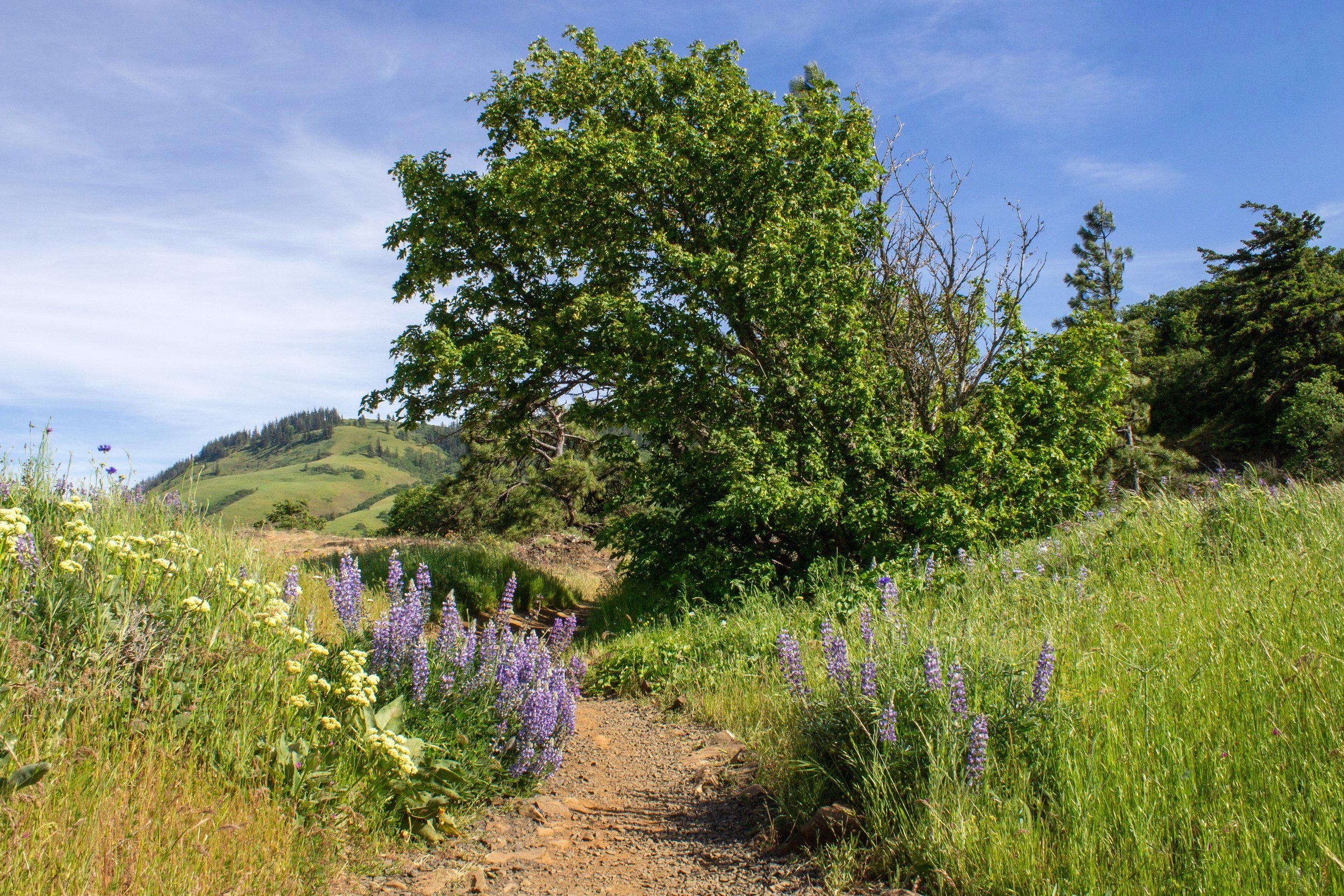
Lupines and buckwheat along the trail
You soon enter the first of several little wooded groves on the way to Tom McCall Point. Wildflowers add color to the grasses beneath the trees. Early in the season, Columbia desert parsley thrives here. At peak season, look for lupines and balsamroot.

Lupines in the wooded potion of the trail
After the initial easy stroll at the beginning of the hike, the trail starts to climb. The rest of the way will be uphill. Though never intense, expect switchbacks and stairs.
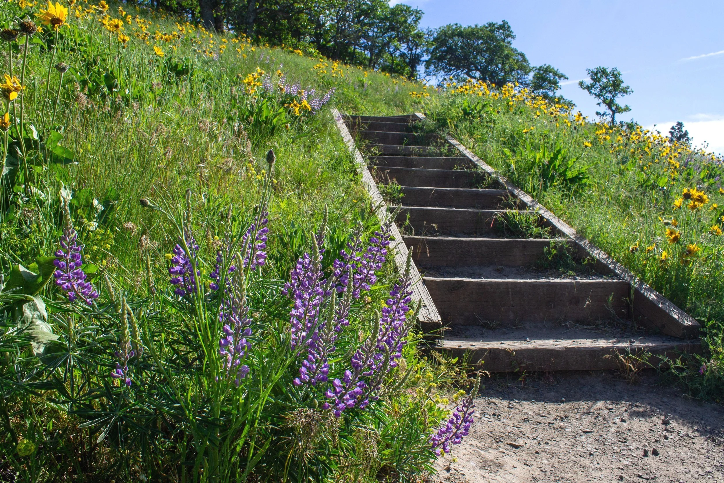
Lupine and balsamroot surround a staircase
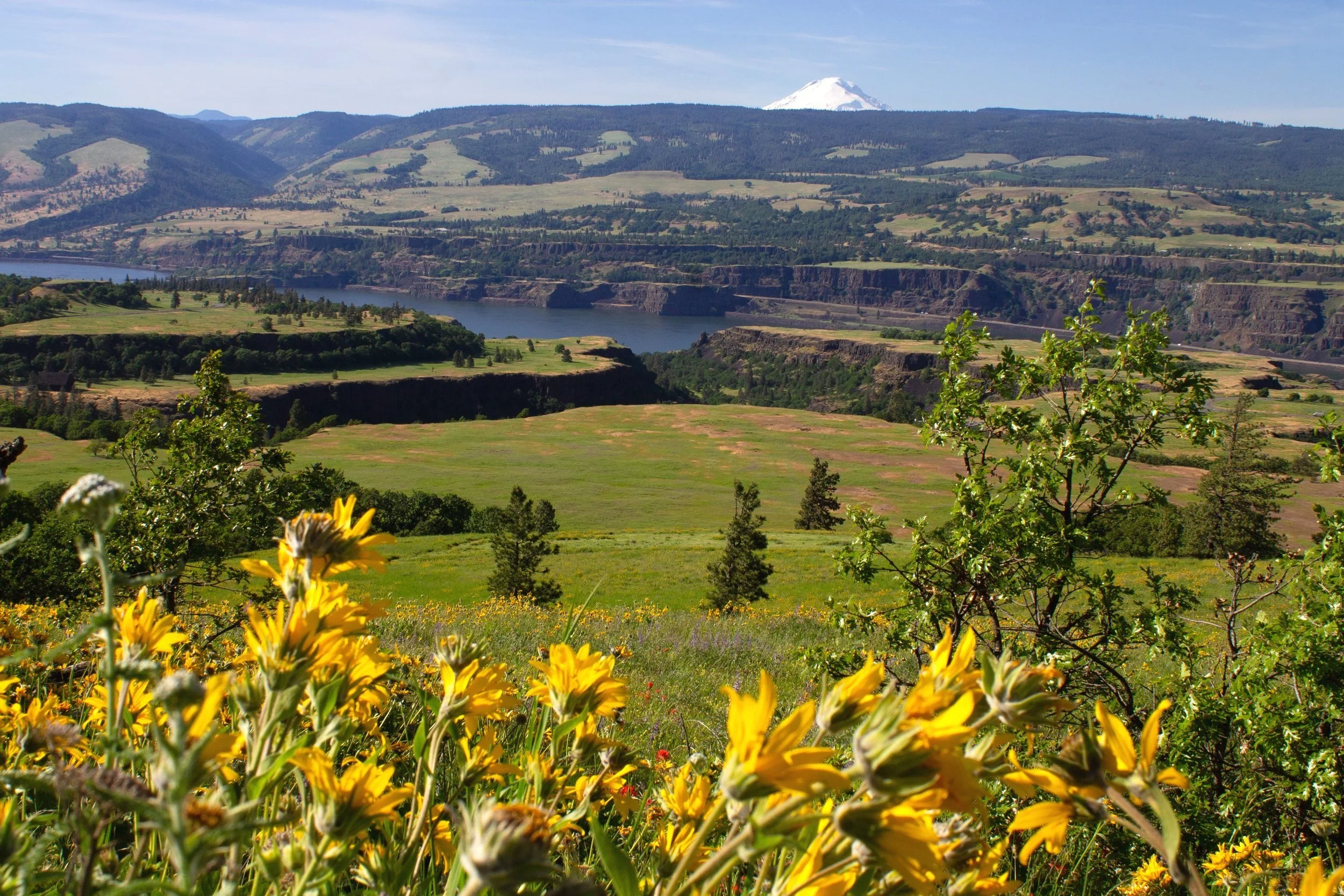
As you climb, the views expand in their scope. You’ll see the Columbia River and the cliffs of Washington most of the way. These cliffs are a sort of high water mark for the ice age floods that tore through this area, stripping away the hillsides as they passed.

The town of Lyle across the river
You’ll also start to see the contours of the Rowena Plateau. Around 15,000 years ago, flood waters would have covered the plateau at over 200 feet of depth, scouring its surface. Rowena Creek next to the plateau has eroded its west side.

Looking north from the trail
Wooded thickets provide a small but welcome amount of shade on hot and sunny days. Look for lichen enveloping the dead branches of the pines.

Magnificent lichen
As before, you won’t be in the trees for long. Mt Adams starts looking more impressive above Washington’s hills. Next to the trail, a balsamroot-covered slope descends steeply.
Balsamroot provides a foreground for the Rowena Plateau and Mt Adams
As you gain elevation, you’ll start seeing different types of wildflowers, including some rare ones. Paintbrush is one of the most striking with its bright red flowers. In the densest wooded areas, prairie stars and larkspur appear in a kind of microclimate within a microclimate.

Prairie stars along the trail
One of the biggest surprises was the dainty blue and white Columbia Frasera, a wildflower I had never heard of before this hike.

A bee visits Columbia Frasera next to the trail
Part way up to Tom McCall Point, you’ll see the first views of the Columbia Gorge to the west. The Hood River Bridge looks tiny in the distance.

Columbia River to the west
And it’s never long before the next Mt Adams panorama.

Mt Adams, Rowena Plateau, and a whole bunch of wildflowers
A highlight of the mid-May wildflowers was the sticky-stem penstemon that started appearing toward the end of the hike. I don’t remember seeing it in April. These deep purple blooms add color to the hills as the balsamroot petals start getting sparse.

Sticky-stem penstemon and balsamroot along the trail
About a mile into the hike, the trail makes a jog to the west, bringing you to an unexpected and show-stopping view of Mt Hood. The wildflower-covered slopes of Tom McCall Point make the perfect foreground.

Mt Hood
Meanwhile, Mt Adams still looms to the north. At this point in the hike, its summit is no longer a white dot but an imposing mountain peak.

Mt Adams
The hike ends at Tom McCall Point, covered with wildflowers and surrounded by the Cascades. You’ll see an interpretive sign with information about the volcanic activity and ice age floods that shaped this area.

Tom McCall Point
Just past it, there’s a “trail closed” sign. Don’t worry, the views are still great without crossing it.

End of the hike
Lupines, balsamroot, and paintbrush are the stars of Tom McCall Point at peak season. You’ll also see Mt Adams to the north and Mt Hood to the west.

Lupines in front of Mt Adams
If you can visit at an uncrowded time, find a bare spot of ground to stop for a snack and some water. It’s one of the most beautiful places you will ever eat a granola bar.

Mt Hood
You may notice a trail that continues to the south. It goes down a bit and then up. I didn’t take it based on the advice from Paul Gerald in his guidebook 60 Hikes Within 60 Miles, saying it doesn’t go anywhere special before running into private land. I’d turn around here and tackle the Rowena Plateau Trail instead if you have more time and energy.

Trail to the south
Rowena Plateau Trail
Distance: 2 miles out and back
Elevation gain: 250 feet
Difficulty: Easy
Pass required: None
Dog friendly: No, dogs are not allowed on the trail.
ADA access: No, not past the Rowena Crest Viewpoint.
Season: All year but best around late April to early May when the wildflowers peak.

Lupines and balsamroot bloom on the Rowena Plateau
I’ve heard people describe the Rowena Plateau Trail as a shorter and easier version of the Tom McCall Point Trail, and I mostly agree. You’ll see a lot of the same wildflower varieties on both trails like lupines, balsamroot, cluster lilies, manroot, fiddleneck, and bachelor buttons. The difference is less about the blooms and more about the land. While the Tom McCall Point Trail climbs away from the Columbia River to reach mountain views, the windswept and rugged Rowena Plateau explores the cliffs up close. You’ll also have a chance to see the weird topography of a land inundated with churning debris-filled floodwater. Do both trails if you have the time and energy. If not, don’t sweat it, each is worth visiting.

A rainbow appears behind lupines and manroot on Rowena Plateau
Getting there
To reach the Tom McCall Point Trail from Portland, take I-84 East until Exit 69 for Mosier. Turn right at the end of the exit ramp onto the Historic Columbia River Highway. As you drive through the town of Mosier, you might want to stop at the port-a-potties by the public parking lot next to the road. Continue on the Historic Columbia River Highway for 6.6 miles. Look for the Rowena Crest Viewpoint to your right. The drive from Portland takes about 90 minutes.
Explore nearby

Check out the other best wildflower hikes in the Columbia Gorge.

Try out the best short hikes in the Columbia Gorge.

Find the best waterfall hikes near Portland.