

How to Visit the Tamolitch Blue Pool


The Tamolitch Blue Pool (also called Tamolitch Falls) is one of Oregon’s mega-popular destinations, and with good reason. The hike to reach it begins in an old-growth forest and then transitions to rugged lava rock, all alongside the cascades of the McKenzie River. The finale is a pool so clear and blue it looks like it can’t be real. The major downside is that the crowds overwhelm the parking lot. I live in Oregon and have been hiking all over the state. The wonders on this trail make it worth finding an off time to visit. Here’s how to get to the Tamolitch Blue Pool in the Willamette National Forest.

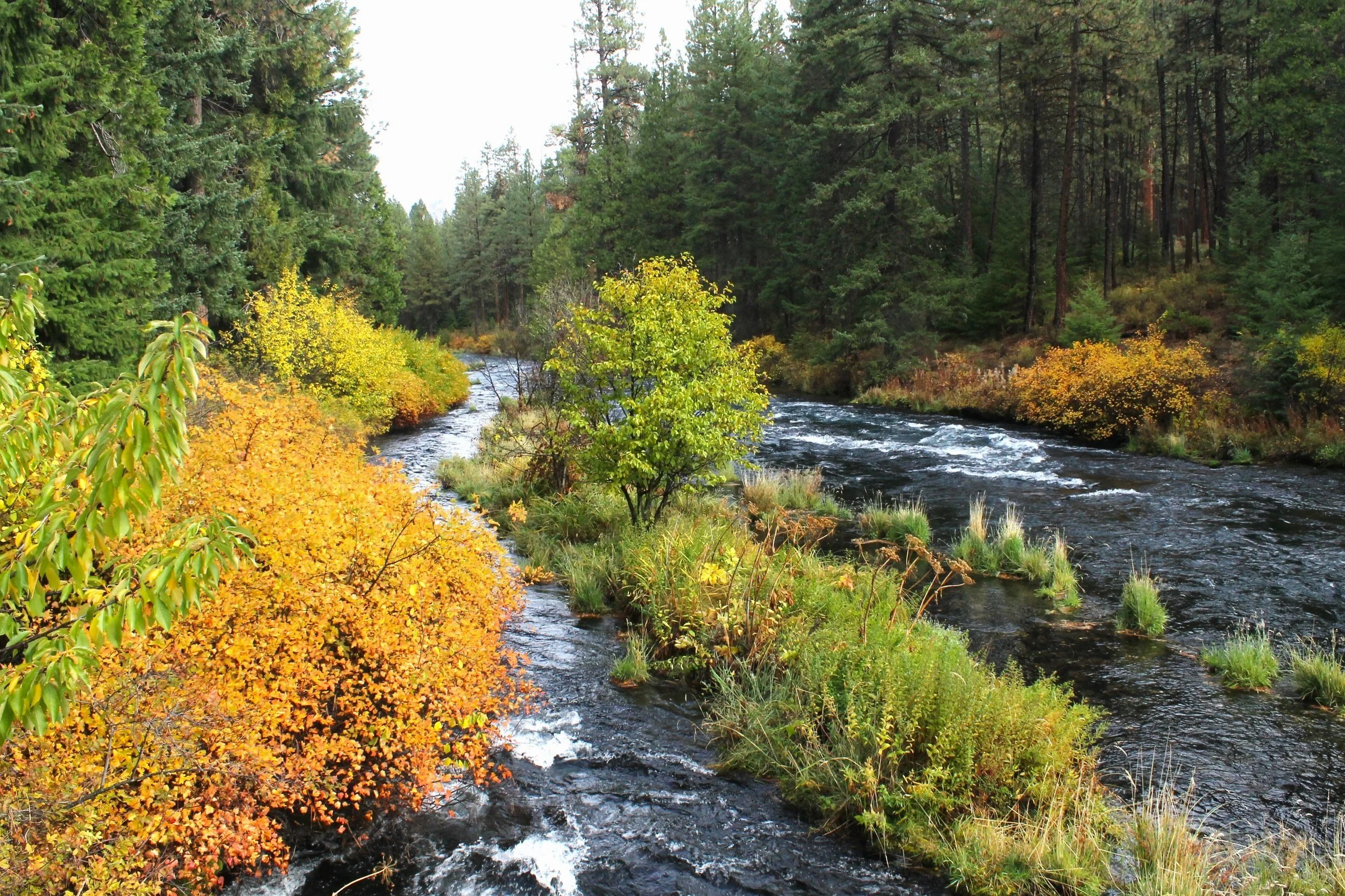
The trail to the Tamolitch Blue Pool follows the McKenzie River
Know before you go
Parking at Tamolitch Trailhead is free. You don’t need a pass or permit.
This hike is VERY popular, and parking is limited. Avoid weekends if you can. Arrive by 8 AM on summer weekends. My friends and I came midday on a cloudy Saturday in April (the hike’s off-season) and found a full parking lot. We were able to park by the powerhouse nearby, adding about a mile of distance to the hike. During summer, this overflow parking will also be full by then.
There are restrooms by the trailhead. They’re pretty rough but usable in a pinch.
Leashed dogs are welcome on the trail.
The Blue Pool’s water is very cold, around 40 degrees F. It’s not a swimming hole. You can try wading or swimming if the cold doesn’t dissuade you. Just be aware of the hypothermia risk, even on hot days.
Don’t jump off the cliffs into the Blue Pool, which risks shock from the cold and impact with rocks. The clarity of the water makes it hard to judge depth. You’ll probably notice the large amount of space around the trailhead reserved for emergency vehicles. It’s related. People have suffered serious injuries and died here. Cliff jumping is the biggest concern.
The trail starts pretty wide and flat but soon narrows and becomes more uneven. It’s not doable with a stroller.
The hike is mostly family-friendly but will be challenging for small children. Be cautious near the cliffs around the Blue Pool.

The hike to the Blue Pool uses the McKenzie River Trail
Trail options
Two trails lead to the Tamolitch Blue Pool:
From the south, the Tamolitch Trailhead begins a 4.2-mile out-and-back hike. This trail is the more popular of the two. It follows the McKenzie River to the Blue Pool.
Starting from the Carmen Reservoir to the north, you can hike 7 miles out and back to the Blue Pool. This trail will be less crowded. It leads through an old-growth forest but does not have views of the river.
Here, I’ll talk about the hike from the Tamolitch Trailhead. Neither trailhead requires a permit. Both allow dogs.

You’ll pass some massive trees on the way to the Blue Pool
On the trail to the Tamolitch Blue Pool
Distance: 4.2 miles out and back (more like 5 miles if you’re unlucky with parking)
Elevation gain: 300 feet
Difficulty: Moderate
Pass required: None
Dog-friendly: Yes, leashed dogs are welcome on the trail.
ADA access: No
Season: Potential year-round. June - August is the most popular season. The trail gets snow in winter but may still be doable depending on the levels.

Head down this road and look for the trail on your right
The details:
Once you’ve made it to the trailhead, you’ve already done the hardest part of the hike: parking. Make the trek from wherever you managed to find a spot. Then, at the end of the forest service road, follow the little dirt road to the left about 100 feet to reach the McKenzie River Trail. A sign will point you towards the Blue Pool.

Tamolitch Trailhead
The hike to the Tamolitch Blue Pool is packed with beauty long before its famous destination. The trail follows the McKenzie River from start to finish, first through an old-growth forest and then through a volcanic debris field. Don’t be discouraged if the parking lot feels like the state fair. The crowds will spread out on the trail, giving you more solitude than company on the journey.

Trillium is among the first wildflowers to emerge near the trail in April
Wildflowers pop up in the undergrowth in spring. The first trillium and a few red flowering current blossoms had opened by my mid-April hike.

First footbridge
As you walk, towering Doug firs, western red cedars, and western hemlock surround you. This hike reminded me of the incredible scale of the Willamette National Forest’s trees, which make even the giants of the Columbia Gorge seem small. After about 0.2 miles, you’ll cross a little wooden footbridge over a stream.

Stream on the McKenzie River Trail
Moss covers the rocks, trunks, and branches around the trail, a testament to the age of the forest. Ferns and Oregon grape fills the understory.

McKenzie River
During the first half of the hike, you’ll be walking alongside the McKenzie River. On sunny days, the water is a bright opalescent blue. On the cloudy ones, it can be dark and moody. After the hike, I was surprised by how much my pictures looked like the enchanted forests of German fairytales. In person, the forest felt inviting even on a dreary day.

Second footbridge
You’ll cross a second, longer wooden footbridge about 0.5 miles after the first. This one makes a gentle bend as it spans a wide babbling stream that comes from a spring nearby.

Cross this cool bridge
After the bridge, you’ll continue for a short distance next to the McKenzie River and then begin to gain some elevation. You’ll still be following the river, just from above it from here on.

McKenzie River
Around halfway to the Blue Pool, the landscape changes. The trail begins winding through piles of rough volcanic rock instead of ancient trees. The Belknap Crater deposited these rocks during its eruption only 1,600 years ago.

Lava rock enters the scene
Several viewpoints next to the trail overlook the pearly blue McKenzie River from above. You’ll see a stark difference between the living canopy around the hiking trail and the many needless trunks on the other side of the river. A wildfire burned this area in 2016.

McKenzie River from a trailside viewpoint
The Tamolitch Blue Pool is a strange feature of the McKenzie River. The river begins at Clear Lake and flows south, forming countless picturesque cascades and two impressive waterfalls, Sahalie and Koosah Falls. Then, it does something odd. It goes underground. The Belknap Crater’s eruption 1,600 years ago buried several miles of the McKenzie River, which reemerges at the Blue Pool via underground springs. For a striking visual, take a look at the satellite view on Google Earth. You’ll see an expanse of gray stretching out from Belknap Crater amid an otherwise green forest.

McKenzie River viewpoint
As you hike through the lava rock, look for some wildflowers that grow despite the lack of soil. Tiny yellow monkey flowers bloom in unpromising rocky crevices in spring.

Itsy bitsy monkey flowers grow on the volcanic rocks along the trail
Just before the end of the trail, you’ll get your first glimpse of the Tamolitch Blue Pool through the trees. Don’t worry if looks almost black on a cloudy day, it’s about to get a lot bluer up ahead.

Approaching the Blue Pool. Don’t worry. It’s about to get a lot bluer.
The trail ends at the cliffs next to the Blue Pool. Be cautious with kids here. You’ll be about 30 feet above the water. It’s worth finding a rock to sit on and lingering by the pool to admire its unique color. Depending on the light, the water can be anywhere from bright turquoise to dusky sapphire. Even the vibrant green of the moss around the pool looks drab by comparison.

The Blue Pool
The Tamolitch Blue Pool’s color comes from its unusual clarity. Underground springs fill the pool with water too frigid to support any life that would cloud its water.

The waterfall is a rarity at Tamolitch Falls, but you’ll likely see a little stream or two
You may see the name Tamolitch Falls on a map. A waterfall appears rarely, only about a few times a year after heavy rainfall. Chances are you won’t see the falls when you visit, but the Blue Pool is majestic enough without it to prevent disappointment.

Trees reflect off the Blue Pool
The spot where you first reach the Blue Pool is a good place to stop and turn around, especially if you aren’t a regular hiker. The views aren’t necessarily better from here out, just different. You can continue a short distance around the rim of the pool to reach the water if you’re motivated. The trail gets, well, much less like a trail from here. If you do go around, it’s interesting to notice how the water’s color changes with the angle. The pool is also a lovely mirror for the conifers around it.

On the far side of the pool, you can descend to the water
Once you reach the other side of the Blue Pool, you’ll descend steeply down to the water. It’s a bit of a scramble but nothing too intense.

By the water at the Blue Pool
Next to the water, it’s easier to appreciate the Blue Pool’s clarity. You’ll see the rocks underwater in surprising detail. The cliffs around the pool reflect off its glassy surface, giving it the look of an impressionist painting. Dip your toes in if you want. It’s very cold. I wouldn’t recommend swimming, but people sometimes do. I grew up in Minnesota, so being uncomfortably cold isn’t interesting or novel for me. If you feel differently, go in slowly. Watch for signs of hypothermia and have someone with you. Just please don’t be an idiot and jump into the water.

On the shore around the Blue Pool
When you’re ready to head back from the Blue Pool, return the way you came.
Getting there
To reach the Tamolitch Trailhead, take OR-126 (McKenzie Highway) to NF-730. A sign at the turn will point toward the Blue Pool. Once you turn onto NF-730, you’ll pass a small parking lot near the hydroelectric powerhouse. This lot is about 0.5 miles away from the trailhead and is useful for overflow parking if available. Continue past the powerhouse and look for parking on the right side of the road. Take any (legal) spot you can find. Be careful not to park in any of the many no-parking zones, marked with signs. The trailhead will be at the end of the road.
Drive times:
Sisters: 40 minutes
Bend: 1 hour
Eugene: 80 minutes
Portland: 2.5 hours
McKenzie Highway
The McKenzie Highway (OR-126) in the Willamette National Forest is jam-packed with attractions. If you love nature, this area is paradise. Here are a couple of my favorite places close to the Tamolitch Blue Pool.
Sahalie and Koosah Falls

Koosah Falls
A few miles north of the Tamolitch Blue Pool are two spectacular waterfalls along the McKenzie River, Sahalie Falls and Koosah Falls. Both have parking lots nearby so you can see them without hiking. If you’re up for it, a magnificent 2.5-mile loop hike connects the falls with views of the McKenzie River’s aquamarine cascades throughout. For something in between, take the trail between the two waterfalls out and back for a 1-mile hike.

Sahalie Falls
Clear Lake

Clear Lake
Just north of Sahalie and Koosah Falls is Clear Lake, the headwaters of the McKenzie River. Like the Blue Pool, Clear Lake’s frigid waters are remarkably clear. In sunlight, the water reflects so bright a turquoise it’s almost neon. When the clouds roll in, it’s somewhat disappointingly lake-colored. This water is cold! You won’t want to swim. I once hiked around Clear Lake when the temperature was in the 90s and was aching to cool off but couldn’t get deeper than my ankles.
The Clear Lake Lodge rents boats. Taking a boat onto the water is a great way to see its clarity. Look for some submerged tree trunks as you paddle. When Sand Mountain erupted 3,000 years ago, it dammed the McKenzie River and created Clear Lake. The trunks you see in the lake are remnants of the forest that existed before the lake’s creation.

Boat dock at Clear Lake
Clear Lake is popular, but the crowds fall away quickly if you start the 5-mile hiking trail that circles the lake. The trail is forested near the lodge and then passes through fields of lava rock on the far side of the lake. Look for birds in the trees and on the water. I saw a couple of buffleheads when I last visited. After the hike, stop by the little restaurant at Clear Lake Lodge for drinks and snacks.

Cascades along the Clear Lake hiking trail
Explore nearby
Find adventurous things to do around Sister, Oregon.

If you’re heading west on Highway 20, stop and see the waterfalls at McDowell Creek Falls County Park.

To the east, check out the geologic wonders at Newberry National Volcanic Monument.