

Lookout Mountain Hike for Wildflowers and Mountain Vistas


The hike at the top of Lookout Mountain in Oregon’s Badger Creek Wilderness is a perfect example of how a lesser-known spot in the Pacific Northwest can be at least as worth visiting as its most popular attractions. Some of the best views of Mt Hood you can find anywhere are from Lookout Mountain’s High Prairie Trail. Only 7 miles away, Mt Hood’s snowy peak looks enormous from the viewpoints at Lookout Mountain. While you’re here, look for the Three Sisters, Mt Jefferson, Mt Hood, Mt Saint Helens, Mt Adams, and Mt Rainier as well as a wildflower bonanza in summer. Here is everything you need to know about hiking at Lookout Mountain.

Butterflies love the wildflowers at Lookout Mountain like this glaucous penstemon
Know before you go
To park at Lookout Mountain, you need a Northwest Forest Pass or an America the Beautiful Pass. You can buy a day pass online for $5. Buy the pass before you head out since you probably won’t have reception at the trailhead. You can also buy one from a local vendor or Forest Service office on your drive out to the trailhead.
Leashed dogs are welcome on the trail.
The parking area for the High Prairie Trailhead has a picnic table and a vault toilet. The door for the bathroom doesn’t lock, so it’s helpful to have a friend with you as a door guard.
To reach the trailhead, you’ll drive for several miles on an unpaved road. It’s bumpy but doable in a low-clearance vehicle.
The road to the trailhead is not maintained in winter. Visit from July - October to avoid getting stopped on the way up by snow. Expect snow on the trail from November until around the beginning of July.
Stay on the trail. Many wildflowers bloom on Lookout Mountain, and they’re more delicate than people sometimes realize. If they’re damaged, they often don’t grow back.
There are some cliffs and steep areas along this hike, but they are easy to avoid.

View of Mt Hood from the High Prairie Trail
On the High Prairie Trail
Distance: 2.9-mile loop
Elevation gain: 550 feet
Difficulty: Moderate
Pass required: Northwest Forest Pass or America the Beautiful Pass.
Dog friendly: Yes, leashed dogs are welcome on the trails.
ADA access: No
Basic directions:
Two trails begin at the High Prairie Trailhead and make a loop. Take the trail on the right (High Prairie Trail #493) to do the loop counterclockwise. Continue for about a mile.
Turn left onto Divide Trail #458 and follow it for about 0.4 miles.
Take the fork to the right at the next trail junction to head about 0.1 miles up the spur trail to the summit of Lookout Mountain.
Return down the spur trail, then take a right onto High Prairie Trail #493 to complete the loop.

Asters fill the prairie at the beginning of the hike in early July
Hike options:
My favorite way to do this hike is as a counterclockwise loop. I’ve seen directions for a similar out-and-back hike, which reduces the distance by about a quarter mile but also misses some cool views by cutting out the west side of the loop. My directions will be for the loop hike, but if you’d rather do the out-and-back, take the left fork at the trailhead and then another left at the trail junction just before the summit.
Rather than driving most of the way up Lookout Mountain, you can hike up it starting from the Gumjuwac Trailhead off Highway 35 (this trailhead also requires the Northwest Forest Pass). This option is longer and more strenuous, a little over 9 miles roundtrip with close to 3,000 feet of elevation gain.

Shooting stars bloom in the prairie during summer
Detailed directions:
From the parking lot, cross the dirt road to reach the High Prairie Trailhead. You’ll see a wooden sign and two trails that begin there. These trails are the start and end of the High Prairie Loop. To do the loop counterclockwise, take the trail to the right. You’ll walk along a narrow dirt path through a field, which in summer is filled with wildflowers like asters, shooting stars, daisies, and Western bistort.

The trail soon enters an alpine forest and begins heading uphill. There will still be plenty of chances to spot wildflowers like Jacob’s ladder and lupines in the undergrowth. You’ll pass a couple of side trails where people have left the main trail to get a view of Mt Hood. Go ahead and ignore these tempting detours. The best views are from the main trail.

The first great view of Mt Hood is from this pinnacle
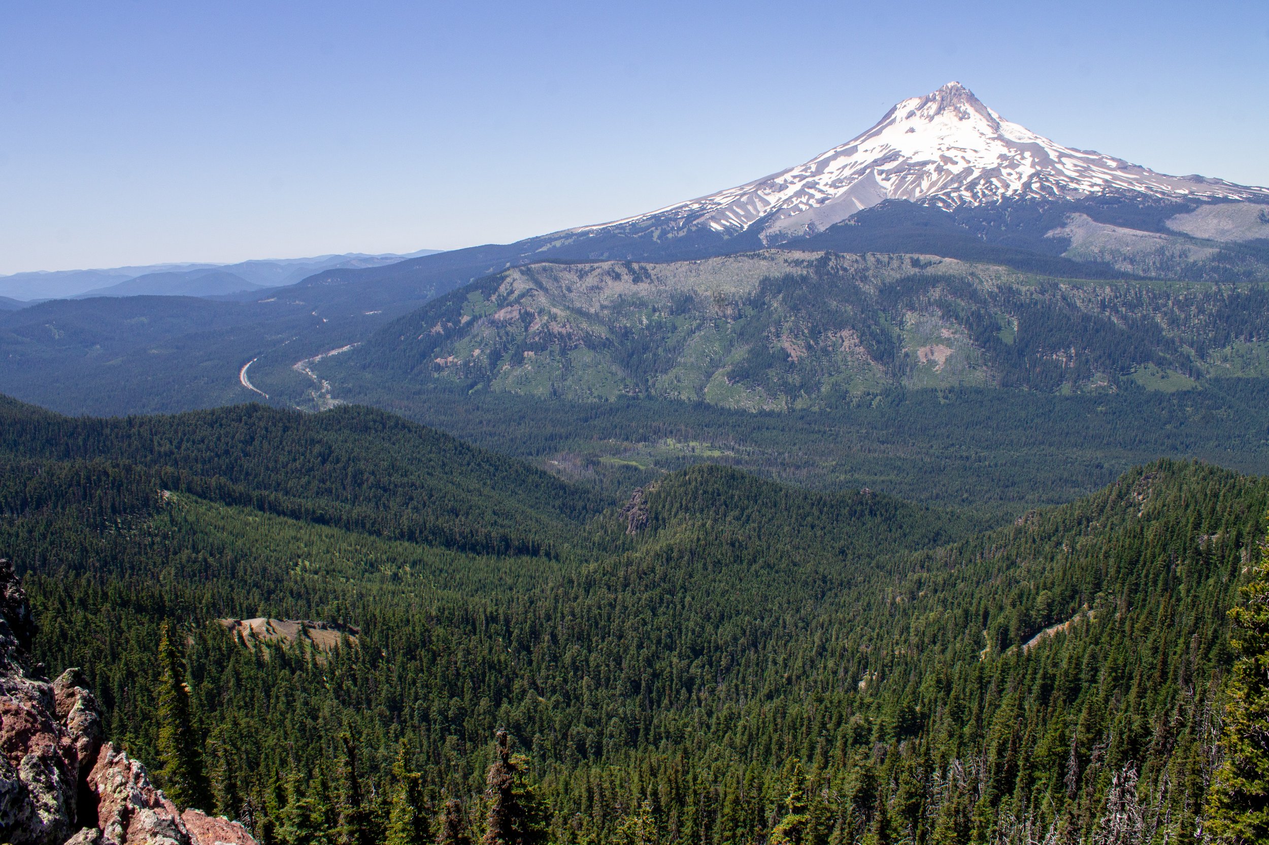
You’ll soon leave the woods and see a rocky pinnacle with the first excellent view of Mount Hood. Scattered lupines and buckwheat blossoms appear in the brick-red volcanic soil around the pinnacle. Looking out from this viewpoint, you’ll see unobstructed views of Mt Hood and its forested foothills. Highway 35 winds around the base of the mountain, looking thin as a strand of hair. You’ll be seeing the mountain from roughly the same elevation as Timberline Lodge.
Mt Hood
As you continue, you’ll head toward the south side of Lookout Mountain and see the first glimpse of the distant peak of Mt Jefferson. The sunny, dusty trail continues steadily uphill. Look for wildflowers along the way, like lupines, scarlet gilia, buckwheat, and subalpine mariposa lilies. A short switchback will bring you back to views of Mt Hood, this time with a colorful foreground of wildflowers.

Scarlet gilia, glaucous penstemon, and buckwheat bloom in front of views of Mt Hood
On the south side of Lookout Mountain, the Divide Trail follows the crest of a ridge with expansive views of the Cascades in multiple directions. Look south for a view of Mt Jefferson and the Three Sisters on a clear day. The distant blue pool you’ll see in the foothills is Badger Lake. The tortuous trunks of whitebark pines add atmosphere to the views from the ridge.

Mt Jefferson is faint but visible on a hazy day
One of the highlights of this hike is seeing the scenery transition from the forested hills of the Cascades to the flat and arid high desert to the east. Lookout Mountain is in the Badger Creek Wilderness, which has a noticeably different character than the Mt Hood Wilderness thanks to the rainshadow cast by the Cascades. Looking east, the pines become smaller and less dense as the land gets drier. Past the Cascade foothills, you’ll see the muted colors of the desert.

The high desert is east of Lookout Mountain
Along the Divide Trail, there are several opportunities to explore the cliffs of Lookout Mountain. Outcroppings provide excellent viewpoints for admiring the volcanic rocks of the cliffs and Mt Hood to the west. Tread carefully here as the dropoffs are steep and the rocks are loose. Growing in the cracks of these cliffs, you’ll see yarrow, buckwheat, and penstemon.

An outcropping points toward Mt Jefferson, which is obscured by smoke on a hazy day
Looking back toward the way you came, you’ll see the summit of Mt Hood behind the cliffs of Lookout Mountain. The overlooks here are great spots to stop for a snack and some water so that you can take your time with the views.

Mt Hood behind Lookout Mountain
After traversing the ridge on Lookout Mountain’s south side, the Divide Trail rejoins the High Prairie Trail. You’ll head down from the ridge and reach a trail junction. Follow the fork to the right to take the short spur to the summit of Lookout Mountain.

Descending from the ridge to rejoin the High Prairie Trail
Once you reach the summit, you’ll find a broad, rocky clearing dotted with buckwheat, yarrow, and penstemon. You’ll also see the remains of the foundation of an old fire tower here. It was fitting, if troubling, that my friends and I saw smoke rise from the hills to the south as we rested here. We learned later it was from the start of the Boulder Fire. On a clear day, look for the peaks of the Three Sisters, Mt Jefferson, Mt Hood, Mt Saint Helens, Mt Adams, and Mt Rainier from 6,525 feet of elevation. Lookout Mountain is the second-highest peak in the Mt Hood National Forest.

Sulfur-flower buckwheat blooms on top of Lookout Mountain
After taking in the views from the summit, head back down the spur and return to the trail junction. Take a right to head back down the hill and finish the loop. You’ll have some shade as you hike through the forest and then return to the wildflowers of the High Prairie.

Mt Hood from the summit of Lookout Mountain
Getting there
There are two ways to reach the trailhead on Lookout Mountain from Portland:
1) Take Highway 26 East past Government Camp, then take OR-35 N for about 22 miles. Look for a nondescript right turn onto Brooks Meadow Rd/NF-44 immediately after you pass Little John Sno-Park. After about 4 miles on NF-44, turn right onto the unpaved Lookout Mountain Rd and continue for 4.5 miles until you reach the parking area for the High Prairie Trailhead.
2) Take I-84 East until Hood River, then take OR-35 S for about 25 miles. Look for a nondescript left turn onto Brooks Meadow Rd/NF-44 a little past the parking lot for Tamanwas Falls. After about 4 miles on NF-44, turn right onto the unpaved Lookout Mountain Rd and continue for 4.5 miles until you reach the parking area for the High Prairie Trailhead.
The second way is longer in terms of distance, but both are about 2 hours away from Portland.
Explore nearby

Chinidere Mountain is another wonderful hidden gem hike near Mt Hood.

Try high-elevation hikes on Mt Hood at Timberline Lodge.

Check out Mt Hood’s best short hikes.