

Quick Guide to Otter Point State Recreation Site
Otter Point is one of the most incredible hidden gems on the Oregon Coast. It has all the majesty of Cape Kiwanda without the crowds (or the $10 parking fee). No signs point to it from the highway. You have to know it’s there. A short and easy walk leads from the parking lot to the end of Otter Point, an otherworldly sandstone peninsula that towers over the Pacific. On a clear day, you can see from Cape Blanco to northern California, almost 100 miles of coastline. After taking in the views from above, relax on one of the stunning and deserted beaches on either side of Otter Point. Here is everything you need to know about visiting Otter Point State Recreation Site.

Cliffs of Otter Point
Know before you go
It’s free to visit Otter Point State Recreation Site. You don’t need a pass or permit to park.
Leashed dogs are welcome.
There are no restrooms or other amenities.
Otter Point has unfenced drop-offs. Explore with caution and stay away from the cliffs. The rock is soft and crumbles easily.
This article is about Otter Point on the southern Oregon Coast near Gold Beach, not the similarly named Otter Rock on the central coast. Since neither place has any otters, it’s an odd repetition and I have no explanation.

Weathering creates some strange shapes on Otter Point
Otter Point
Distance: 0.4 miles out and back
Elevation gain: Minimal
Difficulty: Easy
The layout of Otter Point State Recreation Site directs you to the end of Otter Point, and with good reason. The views from the peninsula are what make this park special. You’ll see the first glimpse of the ocean from the parking lot, complete with a sliver of Agate Beach and a sea stack that looks like a gorilla’s head. Bright red montbretia and pale pink asters provide a lovely foreground in late summer.

Views from the parking lot
On the south side of the parking lot is a sign with park regulations and a warning about unstable cliffs. The hiking trail that starts here leads to Otter Point. Just past the sign, you’ll reach a fork in the trail. Keep right. The left branch goes down to Bailey Beach via the Oregon Coast Trail.

Trail to Otter Point
You’ll reach the first viewpoint in 0.1 miles. It overlooks Agate Beach and, potentially, much more. The marine layer was thick when I visited but the views extend for miles to the north on a clear day. Continue on the trail from here. Better views are just ahead.

Agate Beach from above
Follow the narrow dirt trail for another 0.1 miles to reach panoramic views at the end of Otter Point. A heather-like plant called crowberry grows along the trail. In summer you might see its dark berries. They’re technically edible although not good and best left for the birds.

A trail leads to the end of Otter Point
In late spring and summer, look for wildflowers like coastal strawberries, lupines, and paintbrush. By my mid-August visit, sea daisies were among the last of the blooms.

Sea daisies bloom on Otter Point in summer
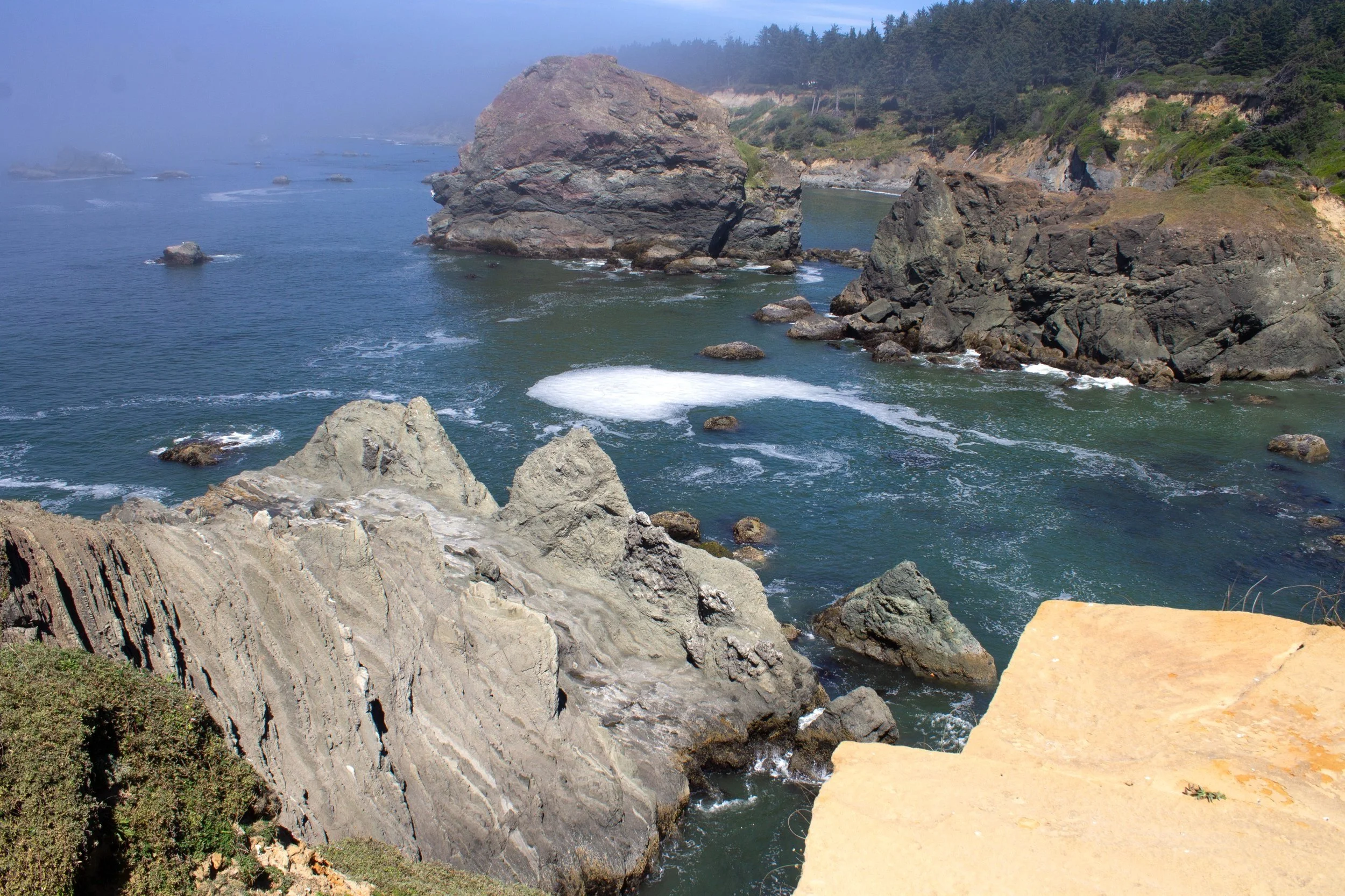
When you reach the end of Otter Point, you’ll have ocean views in every direction. The peninsula ends at a sharp point towering over the waves. Be cautious as you explore. Otter Point is made of sandstone and shale, which crumbles easily. The cliffs could give way without warning. There are no guardrails or other safety measures beyond common sense. If you keep your distance from the edges, it’s safe to wander.

End of Otter Point
Looking north, you’ll see craggy sandstone formations beneath Otter Point. The top of the peninsula is a pale orange that looks surreal against the deep blue of the ocean. Closer to the water, the rock becomes gray. When the marine layer is less aggressive, you can see to Cape Blanco, Oregon’s westernmost point.

Looking north from Otter Point
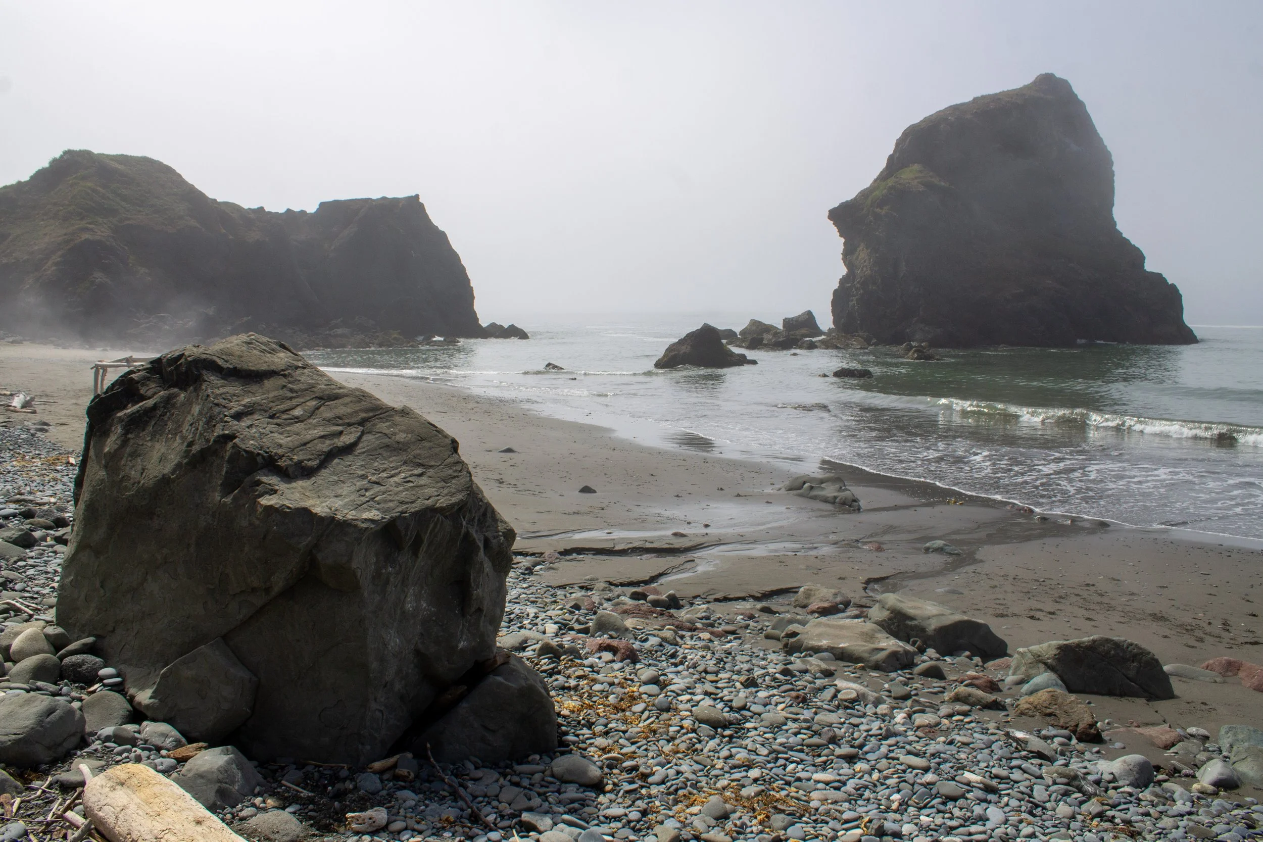
To the south is the long sandy shore of Bailey Beach, which ends where the Rogue River empties into the Pacific. When the visibility is good, the views extend to Point St. George in Crescent City, California. Even when it’s not, the cliffs of Otter Point were impressive enough to make me stop and stare.

Otter Point and Bailey Beach
If you stand in the right place on the south side of the peninsula, you can see a cool sea arch in an outcropping below Otter Point.

This sea arch is hidden at most angles
The rock that makes up Otter Point is about 150 million years old. These mostly sedimentary layers began as a seabed that has since been displaced and tilted. Today the elements are slowly eroding the ancient stone.

Views from Otter Point
The far-reaching views from Otter Point make it an excellent place to look for wildlife. The elevation makes it great for whale watching, especially during the winter and spring gray whale migrations. Bring binoculars to look for birds on the cliffs and sea stacks.

Once you’re done admiring the views from Otter Point, head back the way you came.
Beaches at Otter Point State Recreation Site

Agate Beach
Otter Point State Recreation Site has two beaches, one on either side of Otter Point. Agate Beach is to the north. Bailey Beach to the south. Both are beautiful and uncrowded. You can’t descend directly from Otter Point. Short trails from shore will take you to the beaches.
Agate Beach
Distance: 0.2 miles out and back
Elevation gain: 100 feet
Difficulty: Moderate
Getting down to Agate Beach is a bit of a scramble. The unmaintained beach access trail is short, about 0.1 miles, but steep. Look for a narrow trail at the northeast corner of the Otter Point parking area. You’ll need to look closely to spot it. After crossing a small gully, you’ll see the beach at the bottom of the hill. There was a rope tied to a tree to help with the descent, which I didn’t use. I’d still call it hiking rather than climbing.

The trail to Agate Beach
Agate Beach is a lovely and secluded cove. You’ll see the cliffs of Otter Point to the south. Offshore are several intriguing sea stacks. To the north are coastal bluffs of buff-colored sandstone. Rocks and driftwood line the shore. Unlike Newport’s Agate Beach, you have a decent chance of finding agates in the sand. This beach is small and best at low tide. I’d stay off it during very high tides or storms.
Agate Beach
Bailey Beach
Distance: 1 mile out and back
Elevation gain: 100 feet
Difficulty: Easy
There are two ways to access Bailey Beach. The first is to start from the Otter Point State Recreation Site parking lot. Take the trail toward Otter Point and look for a fork to the left onto the Oregon Coast Trail just after the trailhead. Follow this trail 0.5 miles down to the beach. Unlike the path to Agate Beach, it’s an official trail in good condition.
An even easier way is to drive 0.7 miles south on Old Coast Rd and look for beach access on your right. Across the road is a shoulder where you can park. Follow the flat and gentle access trail about 200 yards to find the beach.

Beach access trail
Unlike Agate Beach, Bailey Beach is a long and sandy stretch of coast. A thick marine layer obscured the views when I visited, but most days you’ll be able to see the cliffs of Otter Point to the north. You can walk a couple of miles south on Bailey Beach until you reach the Rogue River North Jetty in Gold Beach. Cars are allowed on Bailey Beach but I doubt you’ll see any, or anyone, there.

Bailey Beach
Getting there
On Google Maps, search for “Otter Point parking” rather than “Otter Point State Recreation Site.” This search will bring you to the parking lot rather than the general area.
Coming from the south, take Highway 101 N from Gold Beach for about 5 miles. Turn left onto Old Coast Rd and then take an immediate right at the T-intersection to stay on it. Follow Old Coast Rd for 0.6 miles until you see a sign for Otter Point State Recreation Site. Turn left. The parking lot will be at the end of the unpaved road in 0.2 miles. It’s doable in a low-clearance vehicle.
From the north, take Highway 101 S until Old Coast Rd. Turn right onto Old Coast Rd and follow it for 0.2 miles. Turn right when you see the sign for Otter Point State Recreation Site and take the unpaved road 0.2 miles to reach the parking lot.
Otter Point State Recreation Site is 10 minutes north of Gold Beach, OR. The drive from Portland takes 5.5 hours.
Enjoy your trip to Otter Point State Recreation Site!
With love,
Emma
Explore nearby

Visit breathtaking Sisters Rock State Park.

Visit an even more hidden beach, China Beach, in the Samuel Boardman Corridor.

Find more secret beaches on the Oregon Coast.