

Detailed Directions to Secret Beach, Oregon


Secret Beach, or as I call it, Used-to-be-Secret Beach, is one of the social media stars of the Oregon Coast. Despite the remote location and low-profile trailhead, it’s the most crowded beach I’ve visited south of Bandon. Granted, we’re talking about twenty other people on a Saturday afternoon, but still. Has popularity ruined it? Not at all. Secret Beach’s main appeal is scenery rather than solitude. I’ve gone several times, always in middling to terrible weather. I’d happily go and get rained on again. Here is everything you need to know about visiting Secret Beach in the Samuel Boardman Corridor.

Secret Beach has awesome rock formations
Know before you go
It’s free to visit Secret Beach. You don’t need a pass or permit to park.
Leashed dogs are welcome on the trail.
There are no amenities at the trailhead. The nearest restrooms are at Arch Rock State Park.
The trail to Secret Beach is moderately intense without major obstacles. Getting down to the sand is tricky and requires a little climbing.

Secret Beach
Tides at Secret Beach
You can see Secret Beach safely from an elevated viewpoint at any time. To walk on the beach, you’ll need to avoid very high tides and storms. Waves cover the beach when the tide is high enough. You don’t have to arrive right at low tide. My last visit was during a medium tide (around +5) and I had no problem exploring the beach.

Secret beach at a medium tide
Another time, I went at high tide on a blustery winter day. Going down to the beach wasn't safe, so I stuck to the paths above it.

High tide
When the tide is low, there are a few small coves you can explore on either side of Secret Beach. Proceed with caution.

Cove north of Secret Beach. There are more to the south at low tide.
Finding the trailhead
The hike to Secret Beach follows the Oregon Coast Trail and has several potential trailheads. My directions start from the Thunder Rock Cove Viewpoint parking area. I’m starting here because the parking is (relatively) easy to find and close to the Natural Bridges Viewpoint. This way you could see Natural Bridges before or after Secret Beach without moving the car or hiking a long way.
Look for a dirt pullout on the west side of Highway 101, 0.3 miles south of milepost 345 and 0.1 miles north of the Natural Bridges Viewpoint. If you see the sign for Thunder Rock Cove Viewpoint, you’re in the right place. The sign can be a little hard to spot from the highway but is obvious once you park.

Parking area sign
On the trail to Secret Beach
Distance: 1 mile out and back
Elevation gain: 400 feet
Difficulty: Moderate
Passes required: None
Dog friendly: Yes, leashed dogs are welcome on the trail.
ADA access: No
Season: All year. Best at low tide.
Basic directions:
Start from the Thunder Rock Cove Trailhead. Walk until you reach a trail junction and follow the path to the right.
At the next trail junction, keep right again.
Continue until you arrive at Secret Beach.

The forested trail is atmospheric on rainy days
The details:
Look for the trailhead at the north end of the parking area. You’ll see a large sign for Thunder Rock Cove set back in the trees. Take this trail, the Oregon Coast Trail.

Start here
After about 0.1 miles, you’ll reach a trail junction. Take the fork to the right. A helpful sign has an arrow pointing toward “Beach.”

Keep right here
The shady trail winds through a lush Sitka spruce forest. Moss covers the tree branches. Giant sword ferns grow along the trail above a thick layer of false lily of the valley. It’s pretty mellow at the beginning and gets steeper toward the end.

Oregon Coast Trail
Before long, you’ll reach the second trail junction, the most confusing point of the hike. Go right. Multiple handwritten arrows on the signpost point that way and they are correct. You’ll be tempted by the path to the left since it goes downhill and west toward the ocean, but that direction won’t get you to the beach. The trail to the right looks like it leads back to Highway 101 but will veer toward the coast soon.

Follow the arrows to the right
After this second junction, the hike is straightforward. About halfway to the beach, you’ll cross over a small concrete tunnel where Wridge Creek flows under the trail. Around this point is where the trail starts to descend more steeply toward sea level. You’ll get an encouraging glimpse of the ocean on the way.

Preview of the destination
Near the end of the trail, you’ll reach a little wooden footbridge over Miner Creek.
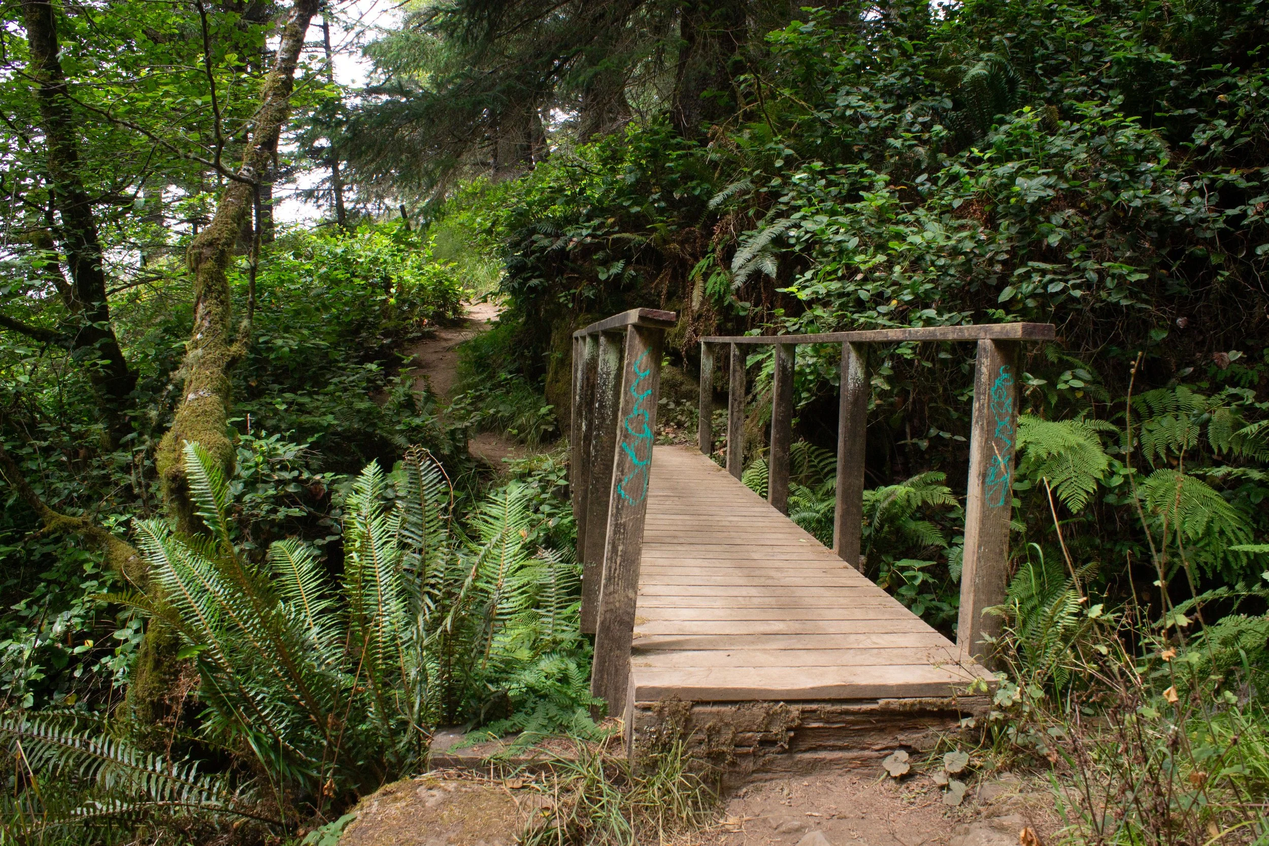
Bridge over Miner Creek
Cross the bridge, taking a moment to admire the cascades next to it.

MIner Creek
Just after the bridge, you’ll see the sea stacks of Secret Beach.

Arriving at Secret Beach
The trail ends at an outcropping capped with a tiny tree growing straight from bare rock. If conditions on the beach are safe, this rocky slope is where you’ll make the scramble down.
Head left to climb down to the beach
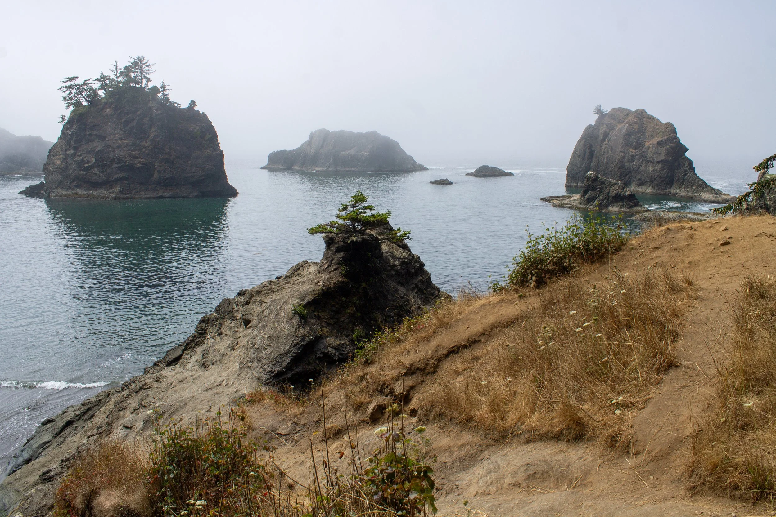
After making the descent to the beach, you’ll have a great view of its small waterfall, which is most impressive in the winter and spring. Rugged headlands frame the beach on either side, making it feel intimate, secluded, and, despite the other visitors, secret.

Secret Beach
Many curious dome-shaped islands stand just offshore of Secret Beach. On top of them are intrepid conifers and, sometimes, seabirds. According to photos online, this beach has never seen a cloudy day. Personal experience says otherwise. This last visit was my first without rain. Only a thick marine layer obscured the visibility. In all conditions, it looks wild, beautiful, and more than a little enchanted.

Sea stacks of Secret Beach
The headland at the south end of Secret Beach is as far as you can go during most tidal conditions. If the tide is low enough, you can pass between the headland and the jagged sea stack next to it. Look for tidepool critters on the rocks as you go and keep an eye on the tide.

Stop here unless the tide is low
Toward the south end of Secret Beach, you’ll see the end of Wridge Creek tickling over a rocky ledge. If you’re looking for cool nooks and crannies to explore, you’ll find a tiny fern-covered canyon by climbing up the rocks.

Wridge Creek
If you visit when the tide is too high to descend to Secret Beach, you can find impressive views from above. A trail leads uphill starting from the rocky outcropping at the north end of the beach. It’s rough but nothing intense.

The Oregon Coast Trail continues north
From here, you’ll can admire Secret Beach’s sea stacks from a point of elevation.

Secret Beach at high tide (and in the rain)
You’ll also see some intriguing rock formations just north of the beach.

Views north of Secret Beach
When you’re ready to head back, return the way you came.
Natural Bridges
One of the benefits of hiking to Secret Beach from the Thunder Rock Cove parking area is how close it is to Natural Bridges. Instead of moving the car, I’d suggest walking the 0.1 miles along Highway 101. A wide shoulder makes the walk safe. The Natural Bridges parking lot is often full, but I’ve never seen more than a few cars at the Thunder Rock Cove lot.

The Natural Bridge Viewpoint parking area is easy to spot from the highway
Once at the Natural Bridges parking lot, follow the hiking trail about 0.1 miles to an excellent fenced viewpoint overlooking the famous rock formations. Unlike the trail to Secret Beach, this one is even and gently graded.

Take this trail to the viewpoint
I recommend turning around at the viewpoint. The trail continues for about 0.3 more miles, but the rest of the hike is steep, has no more views, and ends with a sign warning about dangerous conditions ahead. Hikers often ignore this sign and walk onto the Bridges. Please don’t. I love high places more than just about anybody, but this hike isn’t worth the risk. People have died here.

Natural Bridges
Alternate starts
Since Secret Beach is along the Oregon Coast Trail, there are multiple potential trailheads. These are the others nearby:
The shortest hike begins from a trailhead called Secret Beach Trailhead on Google Maps (the same thing it calls the Thunder Rock Cove Trailhead, confusingly). This one is 0.4 miles north of the Thunder Rock Cove Trailhead on Highway 101. If you start here, the hike is only about 0.3 miles out and back. The downside is that the parking area is hard to spot while driving.
You can also start from the Spruce Island Viewpoint and hike south. The distance will be similar to starting from Thunder Rock Cove. It has the advantage of being searchable on Google Maps by its name.
Kayak tours at Secret Beach

I recently got the chance to explore the coastline of the Samuel Boardman Corridor on a guided tour with Secret Beach Kayaking. These tours paddle to Secret Beach, Thunder Rock Cove, and Natural Bridges, where you can explore parts of the coast that are inaccessible by land with an experienced guide.
Learn more about kayak tours of Secret Beach.
Getting there
The Thunder Rock Cove Viewpoint parking area and trailhead are called “Secret Beach Trailhead” on Google Maps. While accurate, it can be confusing because there’s another “Secret Beach Trailhead” 0.4 miles to the north. The good news is that both will get you to Secret Beach, just via different trails.
I’d say the easiest way to find the Thunder Rock Cove trailhead is by navigating to Natural Bridges. From the south, look for the turnout 0.1 miles past the Natural Bridges parking area. Both will be on the left.
From the north, watch for a turnout on your right, 0.8 miles south of Spruce Island Viewpoint. If you miss it, park at Natural Bridges and walk the 0.1 miles north to the Thunder Rock Cove Trailhead.
Secret Beach is 15 minutes from Brookings, Oregon. The drive from Portland takes 5.5 hours.
Explore nearby

To visit a much-more-secret secret beach, head to China Beach.

See the other best stops in the Samuel Boardman Corridor.

For a stunning beach with amazing sea stacks, visit Harris Beach State Park.

Find more secret beaches on the Oregon Coast.

Find the best things to do in Brookings, Oregon.