

Rowena Plateau Wildflower Hike


Disclosure: post contains affiliate links.
Built by lava flows, scoured by floods, and then piled with volcanic ash, the Rowena Plateau sounds like the last place where life would flourish. Yet every spring countless wildflowers bloom across its windswept fields. The easy, 2-mile Rowena Plateau Trail takes you to stunning viewpoints overlooking the Columbia Gorge with wildflowers in sight every step of the way. For a longer hike, you can combine it with the equally wildflower-rich Tom McCall Trail. Both trails begin at Rowena Crest, one of Oregon’s most impressive viewpoints. Here is everything you need to know about the Rowena Plateau Trail in the Tom McCall Preserve.

Balsamroot blooms next to the Rowena Plateau Trail
Know before you go
Parking for the Rowena Plateau Trail is across the street at the Rowena Crest Viewpoint. Parking is free. You don’t need a pass or permit.
The Rowena Plateau Trail is popular. Parking is limited at the trailhead and fills up on weekends during the wildflower season. Arrive early. Or, go late. I found a lot of empty spots on Sunday at 4 PM.
Dogs are not allowed on the Rowena Plateau Trail, a protected nature preserve.
There are no restrooms or other amenities at the trailhead.
Rowena Plateau is extremely windy. Bring all the layers. I had a light jacket and woke up with a cold the day after the hike. Even in May, I should have had my winter coat, gloves, and hat. Don’t trust the weather forecast.
The Rowena Plateau has some drop-offs near the trail. They are unfenced but easy to avoid if you’re hiking with small children.
Watch for rattlesnakes and poison oak.
Please stay on the trail. Do not pick the flowers.
Rant alert. A note for photographers: please do not lead engaged couples, graduating seniors, and family groups off the trail to trample the flowers for your photos. This place is fragile and protected. Visiting is an honor. If you work with the light but not the land, you are a sloppy technician, not an artist. We can do better!
Rowena Crest Viewpoint
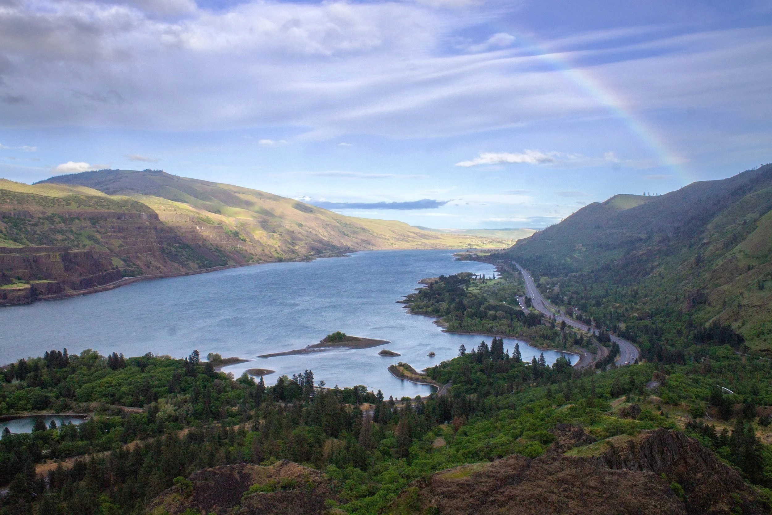
Rainbow at the Rowena Crest Viewpoint
To hike the Rowena Plateau Trail, park across the street at the Rowena Crest Viewpoint. Take a moment to admire the views here before starting the trail. It would be tempting to stay all day if it weren’t for the wind. Rowena Crest is the kind of panorama that can’t be captured from a single angle. Looking down, you’ll see the hairpin turns of the most famous section of Highway 30. To the north, the Columbia River flows past the dramatic slopes of the eastern Columbia Gorge. When the wildflowers are at their peak in spring, the leaves will be out and the grass will be green. Later in the summer, the hills around Rowena Crest turn straw-colored.

Desert parsley blooms in front of the twists of Highway 30
Two hiking trails through the Tom McCall Preserve begin from Rowena Crest. The first is the subject of this article, the Rowena Plateau Trail. It’s the shorter and easier of the two. The other is the Tom McCall Point Trail, which I’ll mention briefly later on. Both trails have excellent wildflowers in spring.
The Rowena Plateau Trail
Distance: 2 miles out and back with a little loop option
Elevation gain: 250 feet
Difficulty: Easy
Pass required: None
Dog friendly: No, dogs are not allowed on the trail.
ADA access: No, not past the Rowena Crest Viewpoint.
Season: This hike is great year-round but best when the wildflowers peak around late April to early May.

Views from the parking area at Rowena Crest
The details:
From the Rowena Crest Viewpoint, walk to Highway 30 and cross the road to reach the trailhead. You’ll see wildflowers before you start the trail. They line the roads, surround the viewpoint, and cover the distant hillsides. Use the boot brush at the trailhead to make sure you aren’t accidentally bringing in seeds into the preserve.

Rowena Plateau Trailhead
The start of the Rowena Plateau Trail is a wildflower bonanza. At peak season, balsamroot and lupines cover the plateau with vibrant yellow and purple. Looking closer, you’ll see dainty cluster lilies, coastal manroot, fiddleneck, bachelor buttons, and Suksdorf’s desert parsley.

Look tons of balsamroot at the start of the trail
Sunny and exposed, the Rowena Plateau is one of the first places wildflowers appear in the Columbia Gorge. I’ve seen early bloomers like grass widows, Columbia desert parsley, and prairie stars as early as February. The showiest displays come later. Late April and early May are generally safe bets for timing. In the early bloom season of 2024, the flowers were at their peak towards the end of April. I’d expect some late bloomers to last until early June.

The trail approaches the canyon to the west of the Rowena Plateau
Part of what makes the Rowena Plateau so captivating is the contrast between the wildflowers and their setting. The flowers are pretty, fragile, and ephemeral. The land is rugged, expansive, and ancient. Together, they have an unlikely harmony. Harsh winds tear across the plateau and yet few petals fly off the vulnerable-looking flowers. Tiny blooms dot the plateau’s towering cliffs. Desert parsley especially has a knack for growing in inhospitable places.

Balsamroot and lupines on the Rowena Plateau
The Rowena Plateau Trail heads toward the cliffs through a field of wildflowers, mostly lupine and balsamroot. The trail doesn’t get close to the drop-offs, but you will get better views of the canyon next to the plateau as you walk. Rowena Creek flows at its base.

Cluster lilies love the Rowena Plateau
The Rowena Plateau has an intense geologic history. Like much of the Columbia Gorge, far-traveled lava flows covered this area millions of years ago and hardened into basalt. You’ll see it exposed in the plateau’s cliffs.
Around 15,000 years ago, massive amounts of glacial meltwater tore through the Gorge in a series of floods at the end of the last ice age. These floodwaters were so high that Rowena Plateau was submerged under 200 feet of rushing water. This floodwater would have been murky and full of debris like logs, boulders, and icebergs.
Finally, after the floods, ash from Mound St Helens fell on the plateau, leaving a lumpy layer of soil on top of the basalt.

Wildflowers grow near (and on) the cliffs
The Rowena Plateau Trail makes a gentle curve and then heads northwest across the plateau. After the initial explosion of yellow, balsamroot becomes much less common along the trail, a legacy of past cattle grazing. The fence by the trailhead kept cattle from wandering. You’ll likely notice that most of the balsamroot is on the other side of it. Although the grazing stopped, the flowers have yet to return to their previous abundance.

The trail heads across the Rowena Plateau
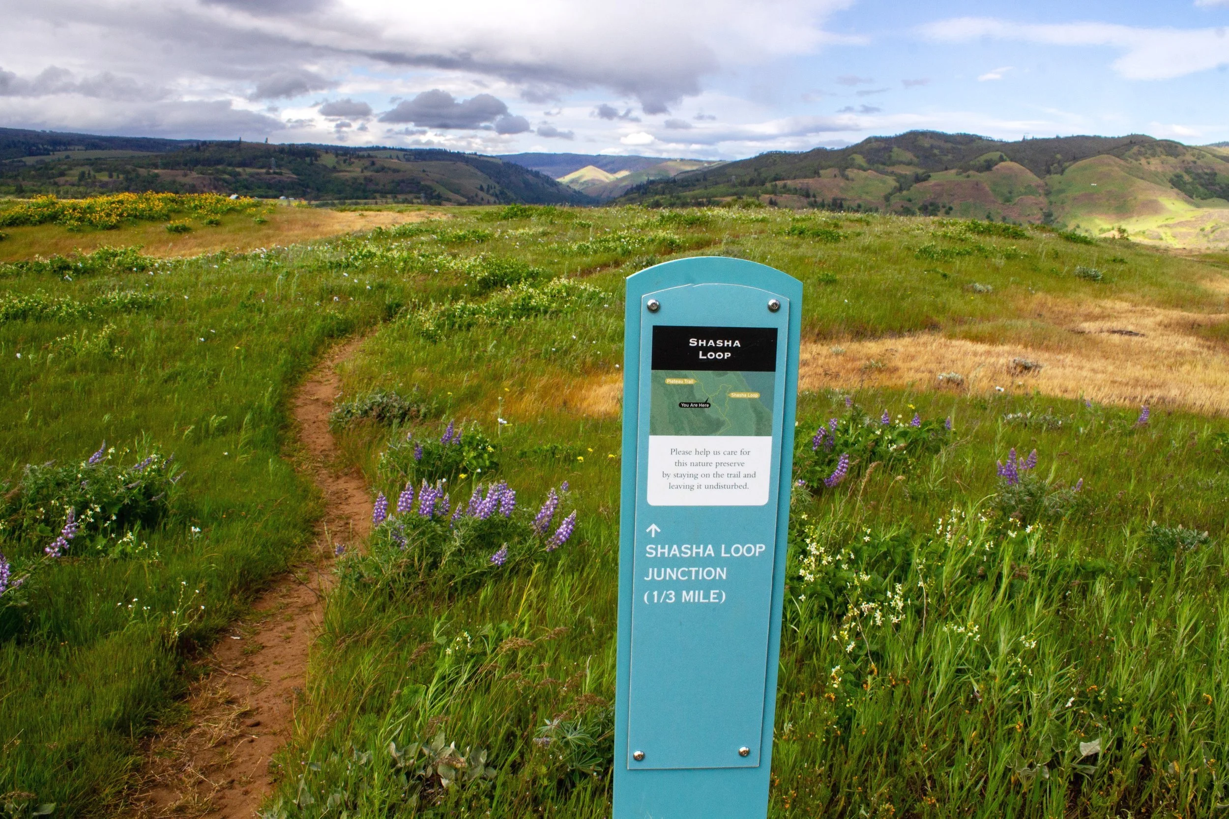
After about 0.25 miles, you’ll reach a junction with the trail for the Shasta Loop, marked with a sign. Going right takes you on an optional detour that will meet back up with the main trail in 0.3 miles. If you keep left, you’ll head towards the end of the plateau more directly. I like taking the loop on the way out and returning on the main trail for some variety. If you have little kids, you might want to stick to the main trail to stay farther from the cliffs.

Lyle, WA, across the river
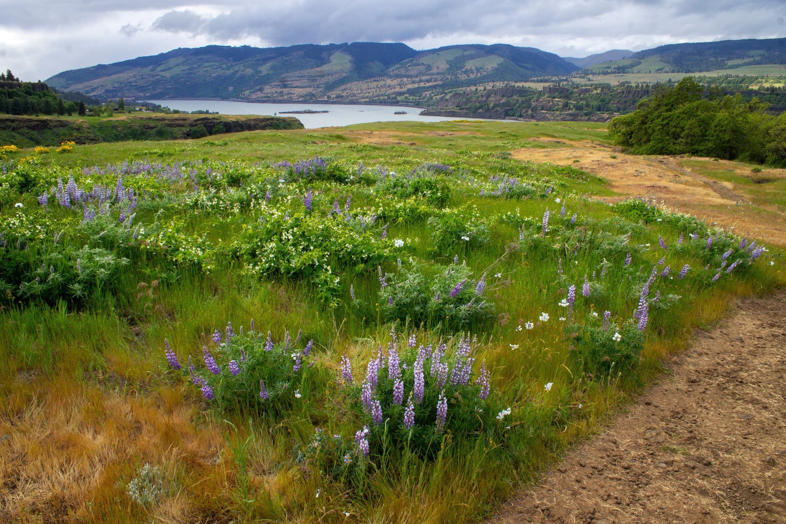
If you take a right for the Shasta Loop, you’ll head toward the northern side of the Rowena Plateau. Look for views of the Columbia River and the town of Lyle, Washington, from the trail. Across the river, you’ll see the striking basalt cliffs of the Washington Gorge.

Rowena Plateau Trail
Despite being pretty flat and easy, the trail feels wild and sometimes almost forbidding thanks to the ferocious wind and the unusual sense of scale. Being in a place where we feel as small as we are is rare. Here, it’s obvious that we have more in common with the teensiest cluster lily than the vast expanses of land, water, and sky.

Lupines on the way to Rowena Pond
The Shasta Loop circles Rowena Pond, the first of two small kolk ponds along the trail. Watch for poison oak near its banks. The floods at the end of the last ice age created the depressions you see on the Rowena Plateau, including the ponds.

Look for Columbia River views along the trail
As you walk, you’ll probably notice some odd lumps and hillocks. These are Mima mounds, a geologic mystery. Theories on how they form range from burrowing animals to seismic activity to freeze-thaw patterns. The Mima mounds of the Rowena Plateau are subtle compared to some other sites in the Pacific Northwest, most notably the Mima Mounds Natural Area Preserve near Olympia, Washington. Still, their strange uniformity draws the eye.

Wildflowers make the most of a tiny stream near the first kolk pond
When you’re close to the ponds, look for the tiny streams of water where popcorn flowers and monkey flowers thrive.

Wildflowers around the Shasta Loop
You'll reach an unmarked trail junction at the far end of the Shasta Loop. Keep left to finish the loop and return to the main trail. If you go right, you’ll follow along the edge of the plateau and meet back up with the main trail a little farther on. Either way works. It can get confusing here but the Columbia River helps make the navigation easier. Just be sure to stay on well-worn trails.
End of the Shasta Loop
Once you meet back up with the main trail, it’s a 0.5-mile straight shot to the end of the plateau.

Tenacious desert parsley grows in the middle of the trail
Back on the main trail, the canyon to the west of the Rowena Plateau returns to view. Wildflowers continue to add color to the fields.
Lupines near the trail
Around this point in the hike, I met a snake crossing the trail. Not a rattlesnake but still a good reminder to look for more than just flowers.
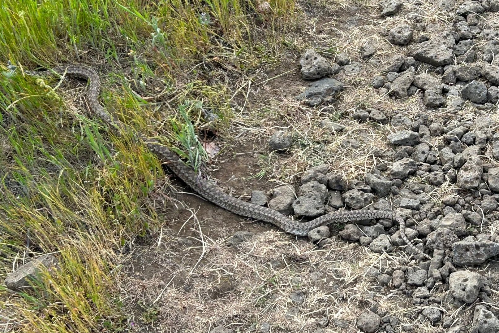
Gopher snake crossing the trail
You’ll pass a second little kolk pond ringed with trees. Like the first, watch out for poison oak near it.

Passing the second small pond
After the pond, you’ll walk by a small wildflower-covered hillock, one of my favorite parts of the hike. Beyond it, you’ll see your destination, the viewpoint at the edge of the plateau.

Manroot and lupines surround the trail
At the end, the views open up to the west. The Columbia River stretches out in both directions. You might also see, as I did, the dark clouds about to soak you with an unexpected shower. As I write, I also cough and sniffle.

Balsamroot on the way to the viewpoint
The trail ends at a dramatic viewpoint overlooking the Columbia Gorge to the west. Here is where the rain started. Naturally, the farthest point from the shelter of the car.

Rowena Plateau Viewpoint
After admiring the scenery around the viewpoint, head back the way you came. You might want to try the Shasta Loop if you skipped it on the way out.

Looking east from the viewpoint
Given the rain, I was happy to take the most direct route back. At least a rainbow appeared and distracted me from my stiff fingers and wet hair. So windy. So cold. So not reflected by the forecast.

A rainbow appears over a field of lupines and manroot
Tom McCall Trail
Distance: 3.4 miles out and back
Elevation gain: 1000 feet
Difficulty: Moderate
Pass required: None
Dog friendly: No, dogs are not allowed on the trail.
ADA access: No, not past the Rowena Crest Viewpoint.
Season: The trail is closed Nov 1 - March 1 to control erosion. Wildflower season will be best in late April and May. The wildflowers at the top of McCall Point bloom a bit later than those of Rowena Plateau.

A balsamroot field is the perfect foreground for Mt Hood
I want to make this article first and foremost about the Rowena Plateau Trail because I feel like it gets overshadowed, both literally and figuratively, by the more famous Tom McCall Point Trail despite being an awesome destination. Still, it would be an oversight not to mention the other spectacular wildflower hike that starts from the same place.
The Tom McCall Point Trail leads from the Rowena Crest Viewpoint to the top of McCall Point. It has a lot in common with the Rowena Plateau Trail. Wildflowers surround the trail from start to finish. Balsamroot and lupines are the most eye-catching. The Tom McCall Point Trail has more distance and elevation gain but also has more species of wildflowers. If you hike on a clear day, you’ll see views of Mt Adams and Mt Hood toward the top. Many hikers do both the Tom McCall Point and Rowena Plateau Trails on the same visit.

Lupines on the Tom McCall Trail
Getting there
To reach the Rowena Plateau Trail from Portland, take I-84 East until Exit 69 for Mosier. Make a right onto the Historic Columbia River Highway (Highway 30) and follow it for 6.6 miles. Look for the Rowena Crest Viewpoint on your right. Park and then cross the street to reach the trailhead. The drive from Portland takes about 90 minutes.
Alternatively: Continue on I-84 East until Exit 76 for Rowena. Turn right onto Highway 30 and continue for 1.4 miles. The route is slightly longer but has two advantages. You’ll pass the Memloose Rest Area on I-84 where you can stop for the bathroom. You’ll also get to drive up the twisty part of Highway 30. The drive time is about the same as taking the Mosier exit.
Enjoy the wildflowers of the Rowena Plateau Trail!
With love,
Emma
Helpful books
Thank you to these books for help with the geology:
Ellen Bishop Morris’s Hiking Oregon’s Geology
For an excellent wildflower guide, I love Russ Jolley’s Wildflowers of the Columbia Gorge. It’s specific to the region and really granular with location.
Explore nearby

Try out the other best wildflower hikes in the Columbia Gorge.

Find the best spring hikes near Portland.