

11 Best Snow-Free Winter Hikes near Portland

Disclosure: post contains affiliate links
While summer is the most popular season for hiking in Oregon, plenty of hikes are at least as much fun in winter. Parking lots begin to have open spaces again. Well-loved and crowded trails become peaceful. Autumn leaves fall away to reveal waterfalls when they are most powerful and dramatic. Whether you’re planning a day of adventure or just need a couple of hours out of the house, here are my suggestions for great winter hikes near Portland that don’t require tire chains to get there.
Tips for winter hiking
For most hikes in the winter, I’d wear hiking boots instead of sneakers. Wetter trail conditions can mean slippery rocks, mud, and puddles. I love my Keen Targhee hiking boots.
I picked trails for this list at lower elevations that don’t often get snow and ice, but it’s still possible. Make sure to check local conditions before heading out.
If you’re looking to avoid the rain, your best bet for dry (and maybe even sunny) weather near Portland in the winter is the eastern Columbia Gorge.
Prepare for the possibility of rain, even if it’s not in the forecast. I’ve gotten caught in unexpected showers many times. Bring layers and a good women’s or men’s raincoat. I’d also suggest a waterproof backpack if you’re carrying anything that can’t get wet.
Cascade Foothills
Trail of Ten Falls, Silver Falls State Park

Behind the North Falls at Silver Falls State Park
Distance: 7-mile loop. There are several options for shorter hikes.
Elevation gain: 1200 feet
Difficulty: Easy
Dog-friendly: Sort of. Dogs are allowed in some parts of Silver Falls State Park, but not on the Canyon Trail where most of the waterfalls are or on the connector trails. You can view the South Falls with a leashed dog but not descend on the path behind the falls. There is an off-leash dog area near South Falls. Upper North Falls is also dog-friendly. You can find the details about dogs in the park here.
Pass required: $5 day pass or annual Oregon State Park Pass required. Pay stations are available on-site.
ADA access: Some. South Falls parking lot, upper South Falls viewpoint, Lodge, restrooms, and some camping options are accessible. Trails around the Lodge and leading to the South Falls are paved and even.
Restrooms: Yes, at both the North and South Falls parking lots.
Driving distance from Portland: 75 minutes

South Falls
The Trail of Ten Falls at Silver Falls State Park is one of Oregon’s most popular and iconic hikes. As the name suggests, this 7-mile loop trail connects no less than 10 waterfalls along its length, including a couple you can walk behind. The hike never gets too strenuous and is so full of highlights that it ends up feeling shorter than it is.
On summer weekends, this park gets packed. Winter is a great time to hike at Silver Falls, both to escape the crowds and to see the waterfalls looking their best. Don’t get me wrong. You won’t have the park to yourself, but there will at least be the chance for moments of solitude amongst moss-covered trees and roaring falls. Plus, since a few of the waterfalls at Silver Falls State Park are seasonal, winter is the best time to see all ten in their full glory.
The largest and most dramatic waterfalls at Silver Falls State Park are the North Falls and the South Falls located on either end of the park. Most hikers begin at the South Falls, which has a much larger parking lot as well as the South Falls Lodge and a gift shop housed in a log cabin. Wherever you begin, the Trail of Ten Falls will lead you through a canyon of moss-covered trees, basalt cliffs, and majestic waterfalls.
One of the most interesting things about Silver Falls State Park is its incredible geology, which is easiest to admire near the waterfalls. There are two distinct layers of basalt visible here, representing different lava flows through the area. Between the two layers is a thin layer of sedimentary rock that formed from the remains of a forest. This sedimentary layer erodes much more easily than the basalt above and below it. Look for it behind the North and South Falls in the most receded area of the cliff face.
Check out all the best waterfall hikes in Silver Falls State Park.
Where to eat and drink after hiking: The South Falls Lodge Cafe in Silver Falls State Park is worth a visit. Local stone, cedar, and fir logs were used to construct the lodge in 1940-1941. Much of the furniture came from two massive myrtle logs expertly crafted into tables and chairs.

South Falls Lodge Cafe
Columbia Gorge
Mosier Twin Tunnels

Eighteen Mile Island in the Columbia River
Distance: 9 miles out and back
Elevation gain: 400 feet
Difficulty: Easy
Dog friendly: Yes, leashed dogs are welcome on the trail.
Pass required: Oregon State Park Pass required. You can purchase a pass at either the East or West Trailhead. It’s $10/day or $30 for an annual state park pass.
ADA access: Very good. The entire trail is paved and even.
Restrooms: Yes, at both the West and East Trailhead parking lots.
Driving distance from Portland: 70 minutes

Mosier Twin Tunnels
The Mosier Twin Tunnels Trail is a great choice for a winter hike near Portland because it is paved throughout. No mud! Go ahead and wear sneakers for this one. The trail is also far enough east in the Columbia Gorge that you’ll have a chance of a sunny day even if it’s raining in Portland.
The Twin Tunnels Trail is a restored section of the Historic Columbia River Highway that is now completely car-free. The trail is 9 miles out and back with trailheads at either end. The Mark Hatfield West Trailhead is in Hood River. The Mark Hatfield East Trailhead is in Mosier. Both trailheads have parking, restrooms, and a pay station, although the west trailhead is more developed (more parking, nicer restrooms). If you want to hike a shorter distance, I’d suggest starting from the east trailhead. Starting from the east, you’ll reach the Twin Tunnels in about a mile.
The tunnels are fun to explore, but the real highlight of this trail for me is seeing the great views of the Columbia Gorge. While there are a few official overlooks, you can see the Columbia River and Washington at many points along the trail. Look for the striking diagonal basalt cliff of Coyote Wall across the river. The Twin Tunnels Trail is one of the best places to see it in its entirety.
Find out more about the Mosier Twin Tunnels Trail and its history in my detailed guide here.
Where to eat and drink after hiking: Take in the views of the Columbia River from the giant windows of Ferment Brewing Company in Hood River.
Starvation Creek Waterfalls
Starvation Creek Falls
Distance: 2 miles out and back
Elevation gain: 200 feet
Difficulty: Easy
Dog friendly: Yes, leashed dogs are welcome on the trail.
Pass required: None
ADA access: Good. Nearly the entire trail is gentle, even, and paved except for the spur up the Mt. Defiance Trail to Lancaster Falls. Accessible restrooms, viewpoints, and picnic tables.
Restrooms: Yes, look for the building next to the parking lot.
Driving distance from Portland: 50 minutes

Dog Mountain from the Mt. Defiance Trail
The Starvation Creek Trail is one of the more underrated trails of the Columbia Gorge, perhaps because it is a bit farther from Portland than the better-known waterfall trails. In winter, you can see four picturesque waterfalls within about a mile, not to mention some truly phenomenal columnar basalt. This hike is also paved almost the whole way, meaning that you can escape the bane of the winter hiker’s existence, mud.
The first waterfall is only steps away from the parking lot. Follow the short path past the restroom building about 0.1 miles out to a viewpoint for Starvation Creek Falls, a 2-tiered 190-foot waterfall that plunges over a huge mossy boulder. Take a minute to admire the hexagonal rock formations around the falls. This columnar basalt was formed by the even cracking of lava as it cooled.
Follow the paved trail from Starvation Creek Falls back west to begin the hike. The trail runs parallel to I-84, and admittedly, one of the downsides of this hike is that you never really get away from the noise of the highway. You’ll soon pass more excellent columnar basalt along the cliff face and seasonal Cabin Creek Falls. You’ll see a trail junction for Starvation Ridge Trail, which is currently closed. Normally, it provides the option to make this hike into a loop. Continue on the paved trail until the Warren Creek Bridge and then begin heading back the way you came.
On the return trip, take a right onto Mt. Defiance Trail to make a short spur out to the last two waterfalls. You’ll see a viewpoint for Hole-in-the-Wall Falls with a couple of picnic tables, which is the end of the pavement. Continue on the dirt trail over a footbridge and then begin climbing a hill. You’ll soon reach a break in the trees that opens onto a view of the Columbia River and the Washington side of the Gorge. Continue until Lancaster Falls and then return to the parking lot.
Where to eat and drink after hiking: Explore the whimsical grounds of McMenamin’s Edgefield in Troutdale, complete with a wine cellar, brewery, and a couple of restaurants.
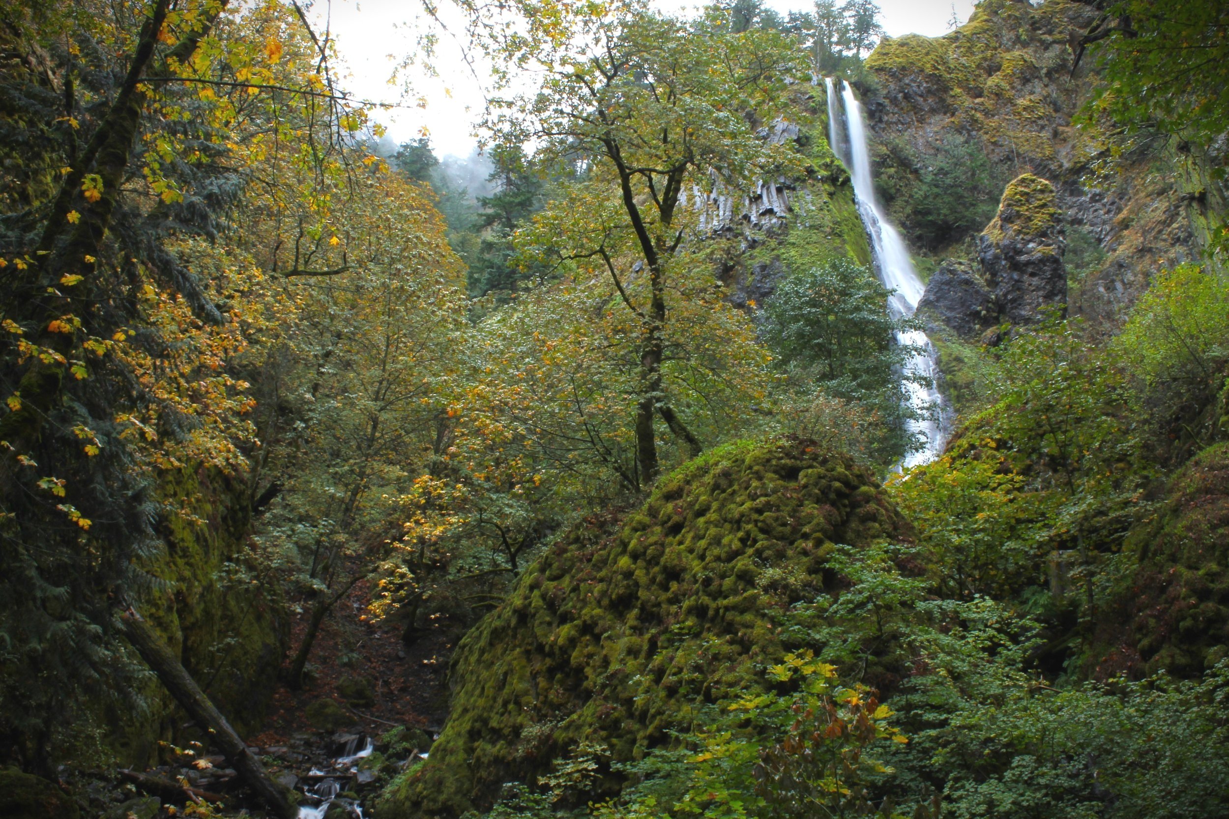
Eagle Creek Trail

Eagle Creek Trail
Distance: 4.2 miles out and back to reach Punch Bowl Falls, options to continue for a longer hike.
Elevation gain: 500 feet
Difficulty: Moderate
Dog friendly: Yes, leashed dogs are welcome on the trail. Be aware of steep drop-offs and narrow sections of the trail.
Pass required: Northwest Forest Pass required. There is a fee station at the trailhead to purchase a day pass for $5.
ADA access: No
Restroom: Technically yes, although it was a grim scene the last time I was there.
Driving distance from Portland: 40 minutes

Punch Bowl Falls
Winter is my favorite time to hike the Eagle Creek Trail. The bare branches of deciduous trees and bushes reveal the contours of the basalt slopes on either side of Eagle Creek. You’ll see regular glimpses of small seasonal waterfalls that form across the creek. Best of all, this trail gets far fewer visitors in winter, allowing for moments of solitude in the rugged Eagle Creek wilderness.
One of the most interesting features of the Eagle Creek Trail is the trail itself, which runs along a cliff above Eagle Creek during much of the hike. The trail’s most impressive sections were created by workmen in 1915 who dynamited a path through a solid wall of basalt, forming a narrow ledge. Metal cables bolted to the cliff wall provide a sense of security along these passages, which are much more pleasant to navigate without a steady stream of other hikers coming from the other direction, as is often the case on summer weekends.
Despite the damage caused by the 2017 Eagle Creek Fire, the slot canyon is still forested with many living trees, and the trail is in good shape after its restoration. About 2 miles into the trail, you’ll see a sign for Lower Punch Bowl Falls. A short (about 0.2 mile), steep trail leads down to Eagle Creek. This trail is a fun spur, but debris from a landslide blocks the access to the falls from here. Continue to the main trail to reach a viewpoint overlooking Punch Bowl Falls.
The Eagle Creek Trail continues for miles past Punch Bowl Falls. Another popular hike is to continue on the trail until Tunnel Falls for a 12-mile roundtrip hike with 8 waterfalls along its length.
Where to eat and drink after hiking: Enjoy views of Bridge of the Gods from Thunder Island Brewery in Cascade Locks.
Rowena Plateau Trail

Rowena Crest Viewpoint
Distance: 2-mile loop
Elevation gain: 300 feet
Difficulty: Easy
Dog friendly: No, dogs are not allowed on the trail.
Pass required: None
ADA access: No
Restrooms: No. There is a rest area a few miles away on I-84.
Driving distance from Portland: 70 minutes

Rowena Plateau Trail
The Rowena Plateau Trail is a great bet if you’re looking for a sunny hike in the winter near Portland. The trail explores a grassy plateau that has excellent unobstructed views of the Columbia Gorge. Unlike the McCall Point Trail, which closes in the winter to limit erosion, Rowena Plateau is open year-round.
To reach the trail, park at the Rowena Crest Viewpoint, which overlooks the Columbia River and a particularly curvy and photogenic section of the Historic Columbia River Highway. Cross the road to reach the trailhead and begin the hike.
The trail makes a flat, gentle loop around the Rowena Plateau. It is one of the best places in the Columbia Gorge to see wildflowers in spring and summer. While you won’t see the showstopping balsamroot or lupines in the winter, look for some early bloomers like grass widows and desert parsley as early as February.
As you make the loop, look for a couple of kolk ponds surrounded by scrub oak and gently sloping mounds of earth formed by blowing sediment. Several great viewpoints along the trail are perfect for taking in the striking contours of the Columbia Gorge. The trail ends at its best viewpoint, which overlooks the Columbia River, the town of Lyle, and the basalt cliffs of the Columbia Gorge.
Since the trail is pretty short and sweet, you may want to check out other hikes nearby.
Make the 3-mile out-and-back hike to McCall Point and see great views of Mt. Hood and Mt. Adams if the trail is open when you visit.
Look for Mt. Hood on the 3-mile Memloose Hills hike.
See more fantastic Columbia Gorge views as well as the Mosier Creek Falls on the 3.5-mile Mosier Plateau Trail.
Where to eat and drink after hiking: Head to Solstice Wood Fire Pizza in Hood River for pizza and beer near the Columbia River. The cocktail menu is also excellent.
Portland
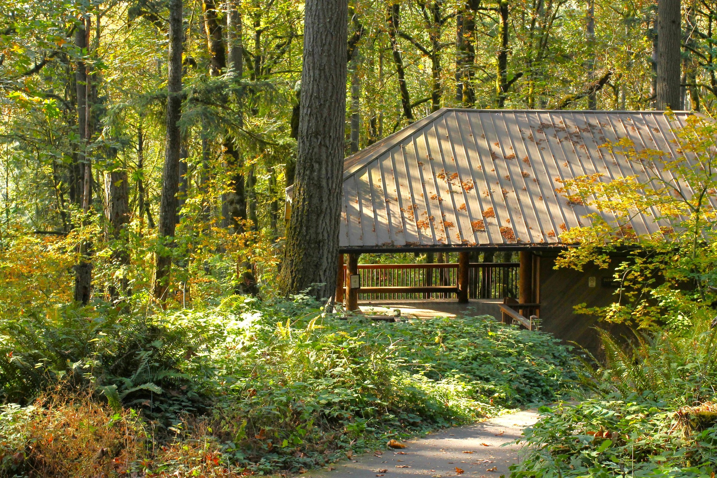
Hoyt Arboretum Trails

Hoyt Arboretum Winter Garden
Distance: Hikes from 0.5 miles to 5+ miles
Elevation gain: Variable, but nothing too strenuous
Difficulty: Easy
Dog friendly: Yes, leashed dogs are welcome on the trails.
Pass required: Parking metered at $2/hour or $8/day. Also accessible by public transportation. Use the Red or Blue Max line, the 63 bus, or the free Washington Park Shuttle.
Restrooms: Yes, at the Visitor Center.
ADA access: Some. Look for the Overlook Trail, Bristlecone Pine Trail, and Visitor Center Loop Trail.

Cyclamen bloom at the Winter Garden
The Hoyt Arboretum is a museum of living trees with over 2,300 species of trees and shrubs from six continents. It makes for an easy winter hiking excursion in nature that doesn’t require leaving Portland. The trails at the Hoyt Arboretum are perfect for last-minute plans and some post-brunch exercise. The park has 12 miles of hiking trails arranged into loops that make it easy to choose your distance. The trails in the Hoyt Arboretum also connect to the rest of Washington Park and Forest Park, so have no fears about running out of trail too soon.
The Arboretum is one of the best places for winter hiking because it has trails designed to stay colorful in winter months. In particular, look for the Winter Garden, which features plants that flower in the wintertime like hellebore and witch hazel, as well as evergreen shrubs chosen for their variety of colors and textures. You can reach the Winter Garden by taking the Beech Trail from the Visitor Center.
The trails at the Hoyt Arboretum are named for the type of trees you can see on the trail, and any coniferous trail is a good choice for winter hiking. I like heading to the Redwood Deck (found on the Redwood Trail) as a destination. You can see Johnson Creek and a grove of redwood trees there from an observation platform, including one sequoia growing up through a hole in the deck.
The Hoyt Arboretum is easy to navigate using the signs present at every trail junction. It’s also helpful to check out a trail map, which includes some loop hike suggestions.
Where to eat and drink after hiking: Head into town and stop by Deschutes Brewery Portland Public House.
Ridge Trail, Forest Park
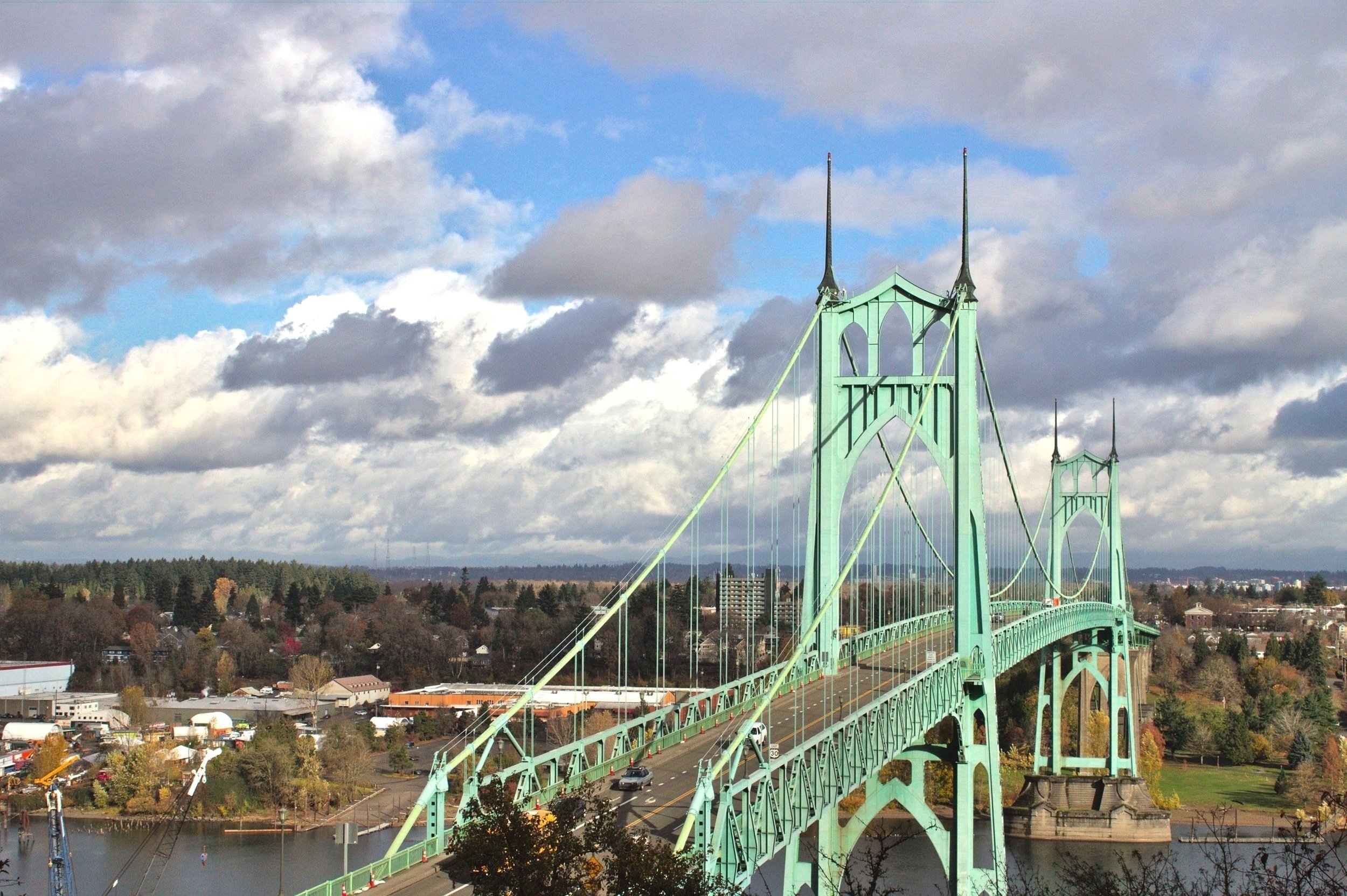
St. John’s Bridge from the Ridge Trail
Distance: 4 miles out and back
Elevation gain: 900 feet
Difficulty: Moderate
Dog friendly: Yes, leashed dogs are welcome on the trails.
Pass required: None
Parking details: There are two possible trailheads to access this trail. Both are free. The better parking situation is at the end of NW Springville Road off Skyline Boulevard. If you park here, you’ll go down the hill to reach the viewpoint and then return up the hill.
The other trailhead, the Ridge Trailhead, is at the bottom of the hill. It is directly off Bridge Road and only accommodates about a half dozen cars. It also requires a short (about 0.2 mile) walk next to the busy street to reach the trailhead. Although the parking is not ideal, I still prefer starting here because I love walking downhill at the end of a hike. Bus line 16 reaches this trailhead.
Restrooms: None at the Ridge Trailhead on Bridge Ave (trailhead at the bottom of the hill). Port-a-potty at the Skyline Blvd trailhead (top of the hill).
ADA access: No. Lower Macleay Trail in Forest Park has a short paved portion that reaches the woods.

Ridge Trail in Forest Park
There are, scientifically speaking, approximately one gazillion possible hikes in Portland’s Forest Park, any of which would be good for winter hiking. I picked the Ridge Trail because it has an excellent view of the St. Johns Bridge and feels like a workout without being very long. It’s a good choice for a winter hike on those days when there is a short break in the rain. That being said, I had a good time on this trail despite being rained on most of the way. Bring your hiking boots for this one, it gets muddy.
Starting from the trailhead on Skyline Blvd (top of the hill), follow the wide path down Fireline 7 until you see a sign for the Ridge Trail on your left. Continue on the Ridge Trail downhill for a little under 2 miles until you reach the viewpoint for the St. Johns Bridge at the bottom of the hill. There will be a small wooden footbridge at the viewpoint.
Despite having a few junctions with other trails, the Ridge Trail is easy to follow by using the signs at the trail junctions. There’s only one unmarked junction. Continue straight when you reach it to stay on the Ridge Trail.
There are options for adding more distance to this trail with a bit more navigation and the help of an offline trail map. Look for the junctions with the Wildwood, Leif Erickson, Trillium, and Hardesty Trails to see more of Forest Park.
Where to eat and drink after hiking: Cross the St. Johns Bridge and visit Stormbreaker Brewing.
Oregon Coast and Coast Range
Wilson River Trail

Pinnacle on the Wilson River Trail
Distance: 22+ miles one way with multiple access points: the Elk Creek, Kings Mountain, Diamond Mill, Jones Creek, Footbridge, and Keenig Creek trailheads. The whole trail is more than a day hike, so just do as much as you want.
Difficulty: Variable, but mostly moderate
Dog friendly: Yes
Pass required: None
ADA access: No
Driving distance from Portland: 60 minutes

Wilson River Trail
Few people hike the Wilson River Trail and I wonder why that is. The trail goes for miles through the secluded wilderness of the Oregon Coast Range while still being an easy driving distance from Portland and with trailheads just off the highway. It’s also close enough to the coast to stop by for a visit after hiking. Even in summer, you’ll encounter very few hikers here, although the Jones Creek day-use area can get crowded on warm weekend days. If you’re hiking in the winter, chances are you’ll have miles of solitude.
One of the challenges of the Wilson River Trail is knowing where to start. With over 22 miles of trail, there is more hiking here than can be done in a day. You could do a car shuttle for a long one-way hike, although that is still a lot to take on. I’ve done sections of the trail for shorter day hikes, which is what most hikers here do. Here are a couple of possible hikes on the Wilson River Trail as a starting point:
Jones Creek Trailhead to the Footbridge is a 7-mile out-and-back portion of the trail that stays pretty close to the Wilson River and doesn’t get too difficult. You’ll pass a picnic area and the Tillamook Forestry Center with its impressive suspension bridge (currently closed, plans to reopen in March 2023) towards the beginning of the hike. A couple of miles in, look for 100-foot Wilson River Falls. The stream at its base crosses the trail. Continue until the Footbridge Trailhead, which makes for a good turnaround point. Take the footbridge across the Wilson River and look for Bridge Creek Falls before heading back.
Kings Mountain to Diamond Mill is an 11-mile out-and-back challenging portion of the trail that feels like you are deep in the woods. This hike includes the Wilson River Trail’s best-known feature, a couple of distinctive rocky pinnacles near Lester Creek (one is pictured in the first photo). You’ll also get dramatic views of the Coast Range through a few breaks in the trees along the way. The hike ends at the Diamond Mill trailhead, which loses something for the ORV noise but does have a lovely wooden suspension bridge over the river. Make a visit to the parking area there for a view of Lester Creek Falls.
You can find excellent detailed guides for the Wilson River Trail through the Oregon Department of Forestry and Oregon Hikers for more hiking options.
Where to eat and drink after hiking: If you head to the coast after your hike, check out The Schooner Restaurant and Lounge in Netarts.
Clatsop Loop Hike

Indian Beach
Distance: 3-mile loop
Elevation gain: 800 feet
Difficulty: Moderate
Dog friendly: Yes, leashed dogs are welcome on the trail.
Pass required: Oregon State Park Pass required. There is a pay station near the parking area where you can buy a pass for $10/day or $30/year.
ADA access: No, not on the trails. There are a couple of excellent accessible viewpoints in Ecola State Park.
Restrooms: Yes
Driving distance from Portland: 90 minutes

Terrible Tilly
The Clatsop Loop Trail is a well-loved hike through one of the Oregon Coast’s most iconic parks, Ecola State Park. In summer, the park and its trails can get packed. Winter brings many fewer visitors to the Oregon Coast when even its most popular trails become almost secluded.
There is good reason for the popularity of the Clatsop Loop Trail. It is a rewarding, family-friendly loop trail through a forest of towering Sitka spruce trees and ends at a viewpoint for Oregon’s most infamous lighthouse, the Tillamook Rock Lighthouse, known as Terrible Tilly. Along the way, you’ll pass log cabins that shelter hikers on the Oregon Coast Trail, a moss-covered bunker that was part of an old WWII radar station, and several viewpoints overlooking the Pacific Ocean.
The viewpoints along the Clatsop Loop Trail are great places to look for whales, particularly in the winter. During the winter whale migration from late December to January and the spring migration from late March until around June, over 25,000 gray whales pass by the Oregon Coast. Elevated viewpoints, like the cliffs of Ecola State Park, are the best places to look for them.
Make sure to stop by Ecola Point while you’re in the park to see views of the incredible sea stacks, including Haystack Rock off the coast of Cannon Beach. If you are up for more hiking, look for the trail from Ecola Point down to Crescent Beach.
Read all about Ecola State Park and the Clatsop Loop Trail in my detailed guide here.
Where to eat and drink after hiking: Just down the road from Ecola State Park, check out Public Coast Brewing in Cannon Beach.
Mt Hood National Forest
Salmon River Trail

Salmon River Trail
Distance: 4 miles out and back (or optional 8 miles out and back if conditions permit).
Elevation gain: About 300 feet to Rolling Riffle Camp
Difficulty: Easy
Dog friendly: Yes
Pass required: Northwest Forest Pass required. There is no pay station or cell phone reception at the trailhead, so purchase a pass ahead of time for $5/day or $30/year. You can buy one online or stop at the Zigzag Ranger Station off Highway 26 before the hike. Begin the hike at the Salmon River West Trailhead.
ADA access: No
Restrooms: No
Driving distance from Portland: 70 minutes

Salmon River
Despite years of hiking near Portland, I made it to the Salmon River Trail for the first time only recently. I had considered going many times before but always ended up choosing another destination, usually one with a big ol’ waterfall or a mountain overlook. It’s easy to get spoiled here. Now that I’ve finally gone, I understand the Salmon River Trail’s popularity. The old-growth rainforest there has colossal pine trees and an undergrowth of massive sword ferns. Thick moss covers many of the tree trunks, giving the forest an otherworldly feel.
Although the Salmon River Trail is in the Mt Hood National Forest, it is still at a fairly low elevation and is a good choice for winter hiking. The first couple of miles are mostly flat and follow the rugged Salmon River through a forested canyon. You’ll cross a few picturesque footbridges over the small tributaries that meet up with the Salmon River. Earlier in the fall, the river is a great place to see salmon migrating. In summer, look for wildflower blooms like trillium along the trail. On a winter hike, enjoy the quiet.
The entire Salmon River Trail is long. The first couple of miles are a good bet for an easy day hike in winter. You’ll see Rolling Riffle Campground on trail maps as a good turnaround point, although I didn’t see a sign for the campground and found its location ambiguous. Instead, I’d look for the self-issued permit station on the trail. You can’t miss it, and it’s not much farther than the campground. Turn around here for a 4-mile roundtrip hike.
If you’d like a longer hike and conditions allow, continue past the permit station (after completing the permit if needed). The trail begins to climb steadily and heads away from the river. After another couple of miles, you’ll reach a clearing in the trees with a view of the Salmon River Canyon. Turn around here for an 8-mile out-and-back hike.
Where to eat and drink after hiking: On your way out, look for the Zigzag Cafe across Highway 26. It looks like a log cabin and has a view of the forest in the back.
Castle Canyon Trail

Castle Canyon Trail
Distance: 2.2 miles out and back
Elevation gain: 850 feet
Difficulty: Hard
Dog friendly: Leashed dogs are welcome on the trail, but be aware there are steep sections and drop-offs.
Pass required: None. Complete the free, self-issued Wilderness Permit at the station on the trail if visiting between May 15th and Oct 15th. There is no parking lot, so use the small pullouts from the dirt road near the trailhead to park. The navigation on my phone showed the trailhead as being about 0.2 miles closer than it was. Look for the sign for the trailhead on the right side of the road to find the trail.
ADA access: No
Restrooms: No
Driving distance from Portland: 60 minutes

Pinnacles Viewpoint
Although short, the Castle Canyon Trail is one of the most difficult hikes on this list due to its big elevation gain over a short distance. It is also a good choice for a winter hike near Portland when you want some time alone in nature. I went on a Sunday afternoon and only met two other hikers on the trail.
The trail begins nice and easy, climbing gently through a forest of pines, alders, and big leaf maples. Fall color lingers in the undergrowth into late November. You’ll cross a couple of unmarked private trails early on. Continue in the direction that heads up the hill. There will be a self-issued permit station toward the beginning of the hike. Complete the permit if visiting between May 15th and Oct 15th.
After about 0.5 miles, the trail begins to climb more steeply, a trend that will continue throughout the rest of the hike. The last 1/4 mile is the most challenging bit due to the steep grade of the hill. This section of the hike is also when you’ll start to see the intriguing pinnacles made of volcanic breccia. Look for the chunks of larger rocks embedded in pyroclastic material.
The trail ends at the Pinnacles Viewpoint on top of one of the pinnacles. There is a narrow path you can take, carefully, out to a viewpoint for the Zigzag Valley and Hunchback Mountain. I would suggest returning the way you came after seeing the viewpoint.
Note that the end of the trail is ambiguous. You’ll see a steep path up the hill that continues past the Pinnacles Viewpoint, which I followed for about another 0.2 miles, thinking that the trail continued. I do not recommend it. I can say with only slight melodrama that the last 0.2 miles were more like vertical miles. The path is extremely steep and heads to a rocky ledge, which was a bit icy. If you climb up the ledge (and I do mean climb), there is a clearing with a view (see bottom photo). Descending is even more difficult and, for me, involved an extremely dignified butt-scoot method.
Where to eat and drink after hiking: Have dumplings and stir fry at Koya Kitchen.

If you get here, you’ve gone too far
The best snow-free winter hiking trails near Portland are, in summary:
Trail of Ten Falls
Mosier Twin Tunnels
Starvation Creek Waterfalls
Eagle Creek Trail
Rowena Plateau Trail
Hoyt Arboretum Trails
Ridge Trail in Forest Park
Wilson River Trail
Clatsop Loop Hike
Salmon River Trail
Castle Canyon Trail
Enjoy the winter hiking trails!
With love,
Emma
Explore nearby

Latourell Falls is another great snow-free winter hike.

Wahclella Falls is awesome in the winter and seldom crowded.
Find hiking trails in the parks of Portland.

Not trying to avoid the snow? Check out these easy snowshoeing trails near Portland.